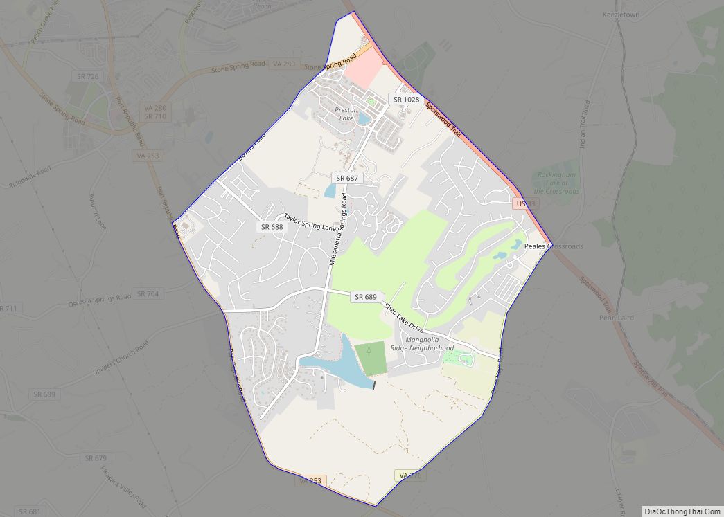
Map of Henry Fork CDP

Map of Henry Fork CDP

Henry Fork is an unincorporated community and census-designated place (CDP) in Franklin County, Virginia, United States, just south of Rocky Mount. The population as of the 2010 census was 1,234. Henry Fork CDP overview: Name: Henry Fork CDP LSAD Code: 57 LSAD Description: CDP (suffix) State: Virginia County: Franklin County Elevation: 1,220 ft (370 m) Total Area: … Read more

Map of Heathsville CDP

Map of Heathsville CDP

Heathsville is a census-designated place (CDP) in and the county seat of Northumberland County, Virginia, United States. Heathsville is in the easternmost county of the Northern Neck of Virginia, which was the birthplace of three of the first five Presidents of the United States – George Washington, James Madison, and James Monroe. It is the … Read more

Map of Hurt town

Map of Hurt town

Hurt is a town in Pittsylvania County, Virginia, United States. Population was 1,304 at the 2010 census. It is included in the Danville, Virginia Metropolitan Statistical Area. Hurt town overview: Name: Hurt town LSAD Code: 43 LSAD Description: town (suffix) State: Virginia County: Pittsylvania County Elevation: 748 ft (228 m) Total Area: 3.51 sq mi (9.10 km²) Land Area: 3.48 sq mi … Read more

Map of Huntington CDP, Virginia

Map of Huntington CDP, Virginia

Huntington is a census-designated place (CDP) in Fairfax County, Virginia, United States. The population was 11,267 at the 2010 census. It is located next to the southern border of the city of Alexandria and is part of the Washington metropolitan area. Its main component is the namesake Huntington subdivision, a late-1940s neighborhood of mainly duplex … Read more

Map of Hot Springs CDP, Virginia

Map of Hot Springs CDP, Virginia

Hot Springs is a census-designated place (CDP) in Bath County, Virginia, United States. The population as of the 2010 Census was 738. It is located about 5 miles (8.0 kilometers) southwest of Warm Springs on U.S. Route 220. Hot Springs has several historic resorts, for the springs helped develop Bath County. Hot Springs CDP overview: … Read more

Map of Horse Pasture CDP

Map of Horse Pasture CDP

Horse Pasture CDP overview: Name: Horse Pasture CDP LSAD Code: 57 LSAD Description: CDP (suffix) State: Virginia County: Henry County FIPS code: 5138552 Online Interactive Map Horse Pasture online map. Source: Basemap layers from Google Map, Open Street Map (OSM), Arcgisonline, Wmflabs. Boundary Data from Database of Global Administrative Areas. Horse Pasture location map. Where … Read more

Map of Horntown CDP, Virginia

Map of Horntown CDP, Virginia

Horntown is a census-designated place (CDP) in Accomack County, Virginia, United States. Per the 2020 census, the population was 912. In the mid-19th-century, Horntown was a stagecoach stop on the route between Wilmington, Delaware and Eastville, Virginia. It lies at an elevation of 39 feet. Horntown CDP overview: Name: Horntown CDP LSAD Code: 57 LSAD … Read more

Map of Innsbrook CDP, Virginia

Map of Innsbrook CDP, Virginia

Innsbrook is a census-designated place in Henrico County, Virginia, United States. The population as of the 2010 Census was 7,753. Innsbrook is a mixed-use corporate center in Central Virginia that was founded in 1979 by local developer Sidney Gunst on property owned by David Arenstein and Henry Stern. Located approximately 13 miles northwest of Richmond’s … Read more

Map of Independent Hill CDP

Map of Independent Hill CDP

Independent Hill CDP overview: Name: Independent Hill CDP LSAD Code: 57 LSAD Description: CDP (suffix) State: Virginia County: Prince William County FIPS code: 5139544 Online Interactive Map Independent Hill online map. Source: Basemap layers from Google Map, Open Street Map (OSM), Arcgisonline, Wmflabs. Boundary Data from Database of Global Administrative Areas. Independent Hill location map. … Read more

Map of Independence town, Virginia

Map of Independence town, Virginia

Independence is a town in Southwestern Virginia‘s Grayson County, with a population of 1,001 as of the 2020 census. As the Grayson County Seat, it is located 71 miles from Winston-Salem, North Carolina, the closest city with a population over 50,000, and is situated on Virginia’s Crooked Road, a heritage trail celebrating the musical heritage … Read more

Map of Idylwood CDP

Map of Idylwood CDP

Idylwood is a census-designated place (CDP) in Fairfax County, Virginia, United States. The population was 17,954 as of the 2020 census. It originally developed as a suburban community along the route of the Washington and Old Dominion Railroad, and later along Virginia State Route 7. The construction of the Capital Beltway in the 1960s, and … Read more

Map of Hybla Valley CDP

Map of Hybla Valley CDP

Hybla Valley is a census-designated place (CDP) in Fairfax County, Virginia, United States, south of Alexandria. The population was 15,801 at the 2010 census, down from 16,721 in 2000 due to a reduction in area, resulting from some of the eastward neighborhoods including much of Hollin Hills being moved to the Fort Hunt CDP. The … Read more