McKenney is an incorporated town in Dinwiddie County, Virginia, United States. The population was 483 at the 2010 census.
| Name: | McKenney town |
|---|---|
| LSAD Code: | 43 |
| LSAD Description: | town (suffix) |
| State: | Virginia |
| County: | Dinwiddie County |
| Elevation: | 335 ft (102 m) |
| Total Area: | 0.93 sq mi (2.40 km²) |
| Land Area: | 0.93 sq mi (2.40 km²) |
| Water Area: | 0.00 sq mi (0.00 km²) |
| Total Population: | 483 |
| Population Density: | 526.94/sq mi (203.49/km²) |
| ZIP code: | 23872 |
| Area code: | 804 |
| FIPS code: | 5148344 |
| GNISfeature ID: | 1495918 |
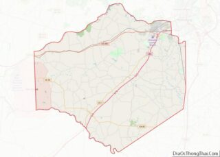
Online Interactive Map
Click on ![]() to view map in "full screen" mode.
to view map in "full screen" mode.
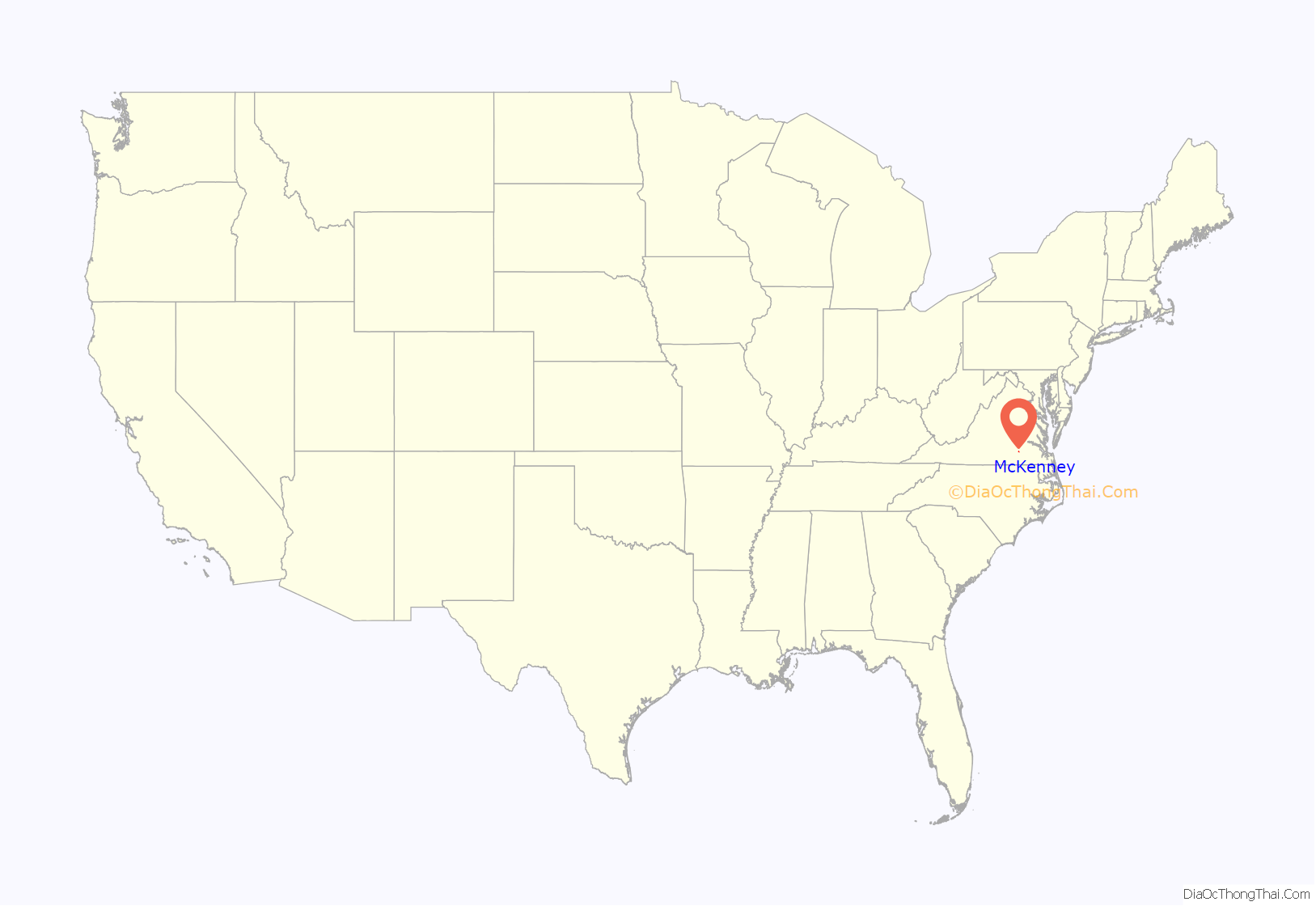
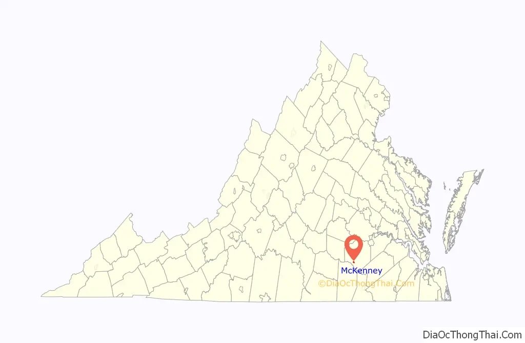
McKenney location map. Where is McKenney town?
History
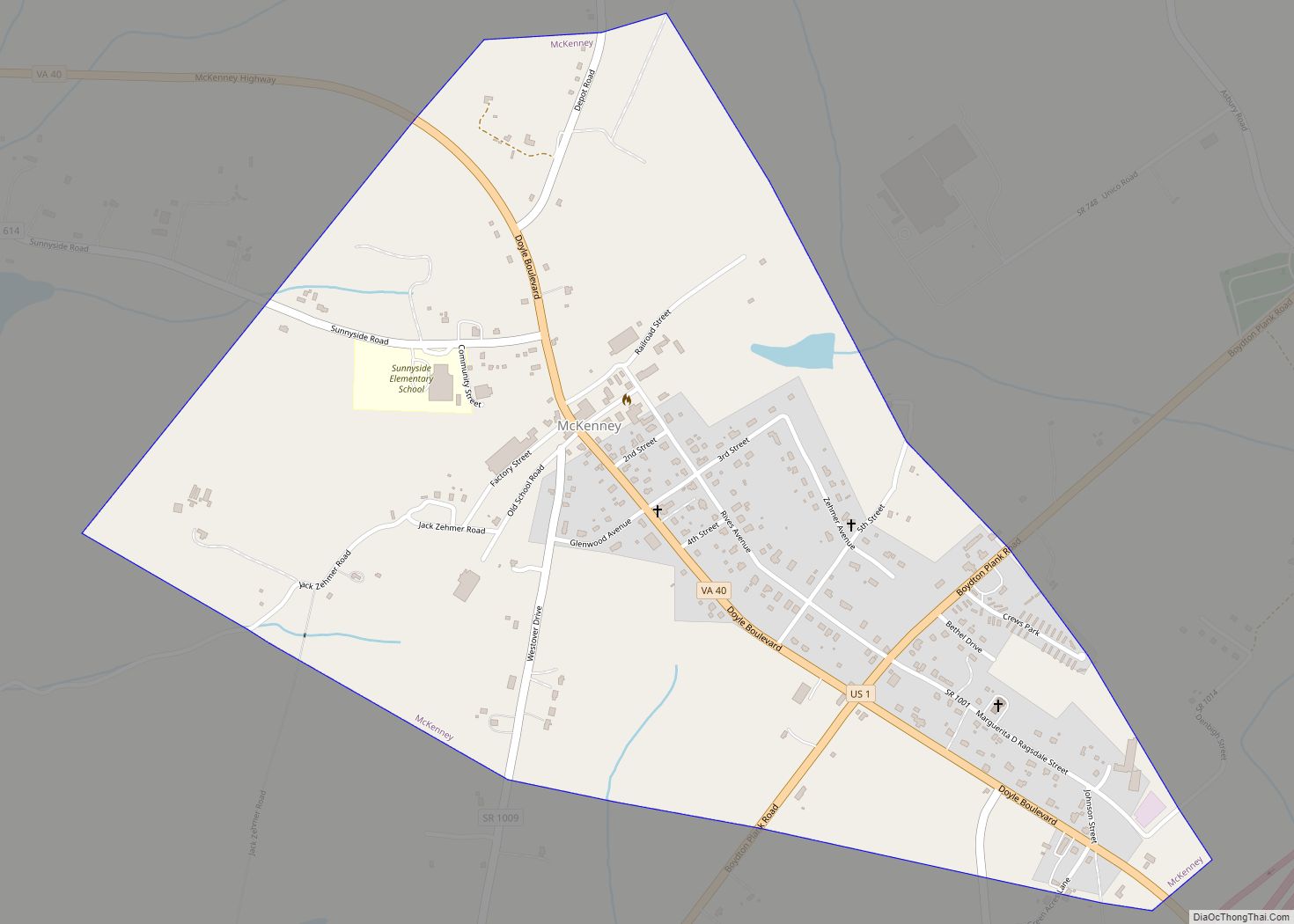
McKenney is located along a former railroad mainline. The Richmond, Petersburg and Carolina Railroad, passing through McKenney from Petersburg, Virginia to Ridgeway Junction (today Norlina, North Carolina), was completed in 1900, at which point it was merged into the Seaboard Air Line (SAL). By 1914, the population of McKenney was estimate by the railroad to be somewhere around 300. The line (dubbed the “S-line” after later mergers) continued to operate until the 1980s, and today McKenney is along the abandoned portion of the CSX Norlina Subdivision.
Montrose, the Sappony Church, and Zehmer Farm are listed on the National Register of Historic Places. Near McKenney is a historical marker, erected by the Virginia Department of Conservation and Historic Resources in 1986, honoring the achievements of educator Sallie Jones Atkinson.
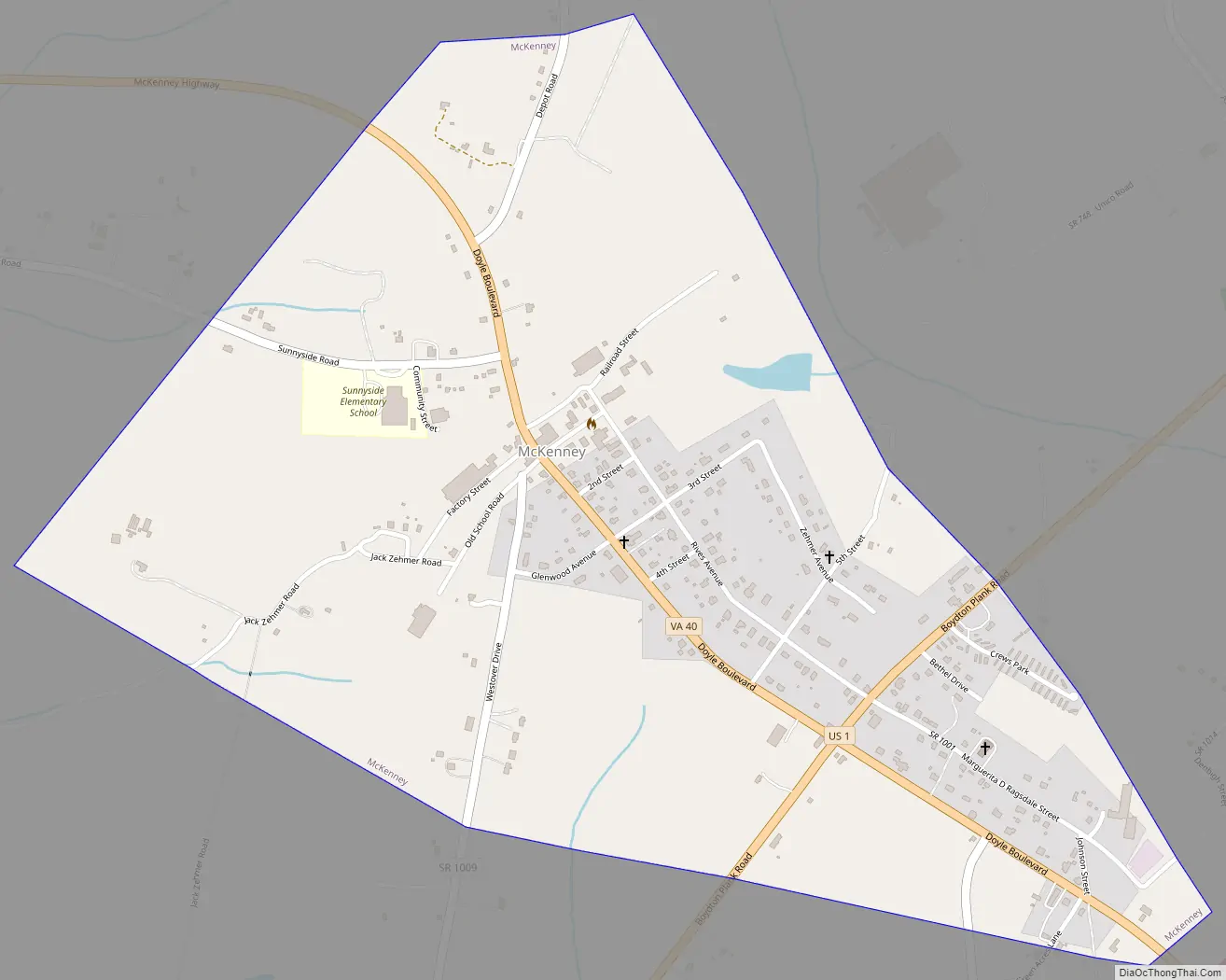
McKenney Road Map
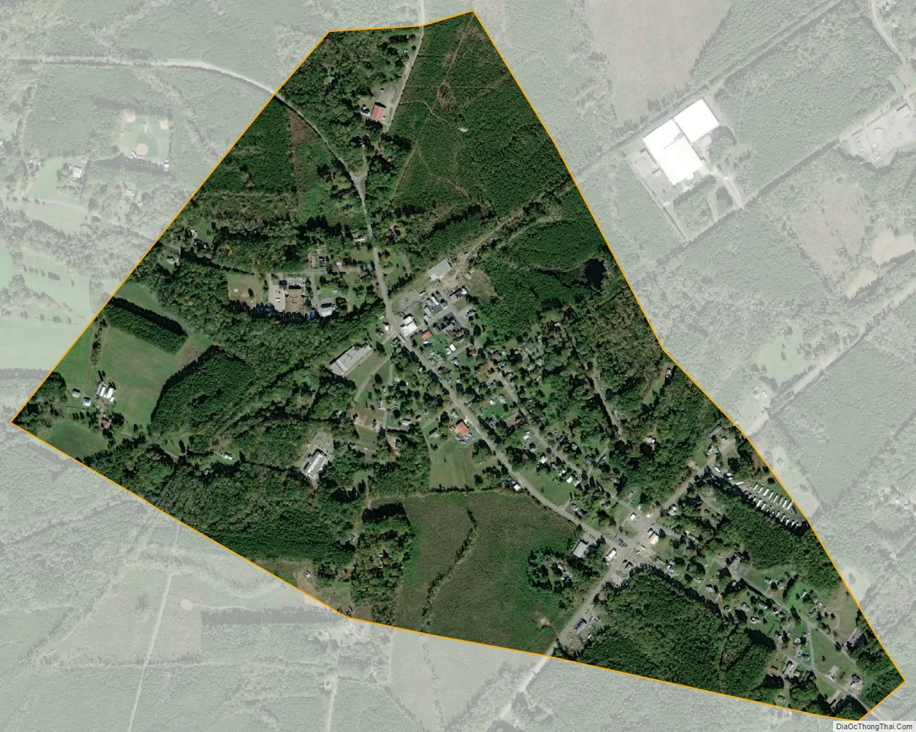
McKenney city Satellite Map
Geography
McKenney is located in southwestern Dinwiddie County at 36°59′00″N 77°43′08″W / 36.983307°N 77.718810°W / 36.983307; -77.718810 (36.983307, −77.718810). U.S. Route 1 passes through the southeast side of town, and Interstate 85 passes just southeast of the city limits, with access from Exit 42. Via either highway it is 26 miles (42 km) northeast to Petersburg and 30 miles (48 km) southwest to South Hill. Virginia State Route 40 passes through the center of town, leading east 18 miles (29 km) to Stony Creek and northwest 20 miles (32 km) to Blackstone.
According to the United States Census Bureau, McKenney has a total area of 0.93 square miles (2.4 km), all land.
See also
Map of Virginia State and its subdivision:- Accomack
- Albemarle
- Alexandria
- Alleghany
- Amelia
- Amherst
- Appomattox
- Arlington
- Augusta
- Bath
- Bedford
- Bedford City
- Bland
- Botetourt
- Bristol
- Brunswick
- Buchanan
- Buckingham
- Buena Vista
- Campbell
- Caroline
- Carroll
- Charles City
- Charlotte
- Charlottesville
- Chesapeake
- Chesterfield
- Clarke
- Clifton Forge City
- Colonial Heights
- Covington
- Craig
- Culpeper
- Cumberland
- Danville
- Dickenson
- Dinwiddie
- Emporia
- Essex
- Fairfax
- Fairfax City
- Falls Church
- Fauquier
- Floyd
- Fluvanna
- Franklin
- Frederick
- Fredericksburg
- Galax
- Giles
- Gloucester
- Goochland
- Grayson
- Greene
- Greensville
- Halifax
- Hampton
- Hanover
- Harrisonburg
- Henrico
- Henry
- Highland
- Hopewell
- Isle of Wight
- James City
- King and Queen
- King George
- King William
- Lancaster
- Lee
- Lexington
- Loudoun
- Louisa
- Lunenburg
- Lynchburg
- Madison
- Manassas
- Manassas Park
- Martinsville
- Mathews
- Mecklenburg
- Middlesex
- Montgomery
- Nelson
- New Kent
- Newport News
- Norfolk
- Northampton
- Northumberland
- Norton
- Nottoway
- Orange
- Page
- Patrick
- Petersburg
- Pittsylvania
- Poquoson
- Portsmouth
- Powhatan
- Prince Edward
- Prince George
- Prince William
- Pulaski
- Radford
- Rappahannock
- Richmond
- Roanoke
- Roanoke City
- Rockbridge
- Rockingham
- Russell
- Salem
- Scott
- Shenandoah
- Smyth
- Southampton
- Spotsylvania
- Stafford
- Staunton
- Suffolk
- Surry
- Sussex
- Tazewell
- Virginia Beach
- Warren
- Washington
- Waynesboro
- Westmoreland
- Williamsburg
- Winchester
- Wise
- Wythe
- York
- Alabama
- Alaska
- Arizona
- Arkansas
- California
- Colorado
- Connecticut
- Delaware
- District of Columbia
- Florida
- Georgia
- Hawaii
- Idaho
- Illinois
- Indiana
- Iowa
- Kansas
- Kentucky
- Louisiana
- Maine
- Maryland
- Massachusetts
- Michigan
- Minnesota
- Mississippi
- Missouri
- Montana
- Nebraska
- Nevada
- New Hampshire
- New Jersey
- New Mexico
- New York
- North Carolina
- North Dakota
- Ohio
- Oklahoma
- Oregon
- Pennsylvania
- Rhode Island
- South Carolina
- South Dakota
- Tennessee
- Texas
- Utah
- Vermont
- Virginia
- Washington
- West Virginia
- Wisconsin
- Wyoming