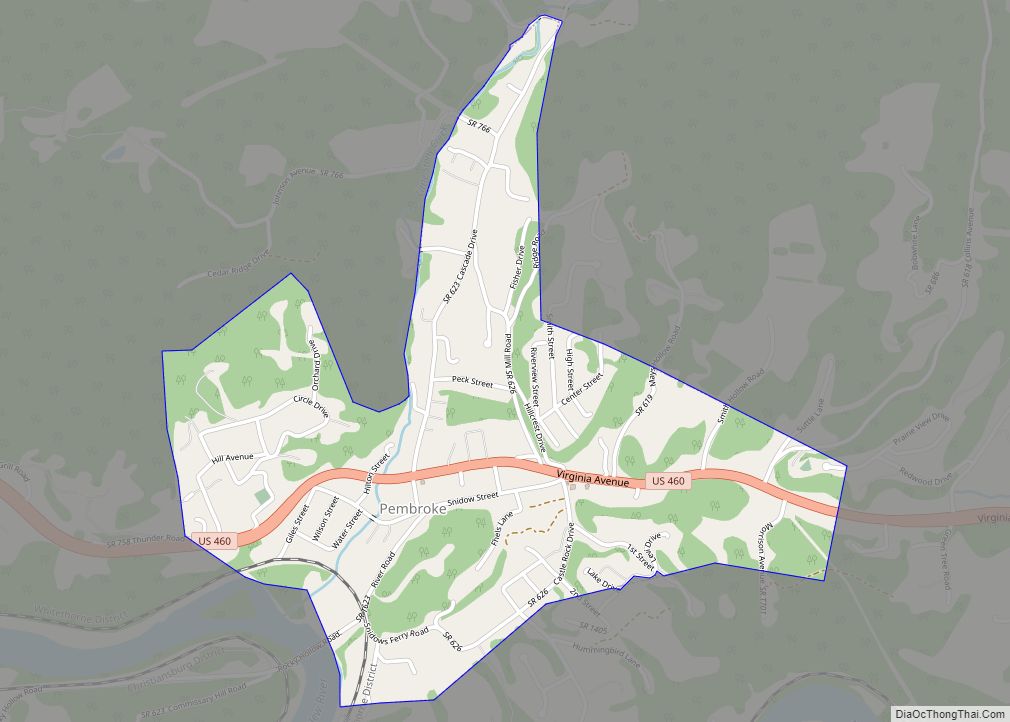
Map of Massanetta Springs CDP

Map of Massanetta Springs CDP

Massanetta Springs is a census-designated place in Rockingham County, Virginia. The population as of the 2010 Census was 4,833. Massanetta Springs CDP overview: Name: Massanetta Springs CDP LSAD Code: 57 LSAD Description: CDP (suffix) State: Virginia County: Rockingham County Total Area: 4,833 ZIP code: 22801 FIPS code: 5150020 GNISfeature ID: 2629754 Online Interactive Map Massanetta … Read more

Map of Mason Neck CDP

Map of Mason Neck CDP

Mason Neck is a peninsula jutting into the Potomac River to the south of Washington, D.C., in the U.S. state of Virginia. It is surrounded by Belmont Bay to the west, the Potomac River to the south and east, Gunston Cove to the northeast, and Pohick Bay to the north-northeast. The census-designated place (CDP) of … Read more

Map of Marumsco CDP

Map of Marumsco CDP

Marumsco was a census-designated place in Prince William County, Virginia. The population was estimated at 37,218 in 2013. The CDP consisted of the major portion of what was the Woodbridge CDP up to 2000, including the subdivisions of Marumsco Village, Marumsco Hills, Marumsco Acres and Marumsco Woods. The area was merged back into Woodbridge prior … Read more

Map of Marshall CDP, Virginia

Map of Marshall CDP, Virginia

Marshall is a census-designated place (CDP) and unincorporated town in northwestern Fauquier County, Virginia, in the United States. The population as of the 2010 census was 1,480. Marshall CDP overview: Name: Marshall CDP LSAD Code: 57 LSAD Description: CDP (suffix) State: Virginia County: Fauquier County Elevation: 685 ft (209 m) Total Area: 2.89 sq mi (7.49 km²) Land Area: 2.88 sq mi … Read more

Map of Marion town, Virginia

Map of Marion town, Virginia

Marion is a town in, and the county seat of, Smyth County, Virginia, United States. It is positioned upon Interstate 81, in the Blue Ridge portion of the Southern Appalachian mountains in Southwest Virginia. The town is named for American Revolutionary War officer Francis Marion. The town limits had a population of approximately 6,000, per … Read more

Map of Mappsville CDP

Map of Mappsville CDP

Mappsville is a census-designated place (CDP) in Accomack County, Virginia, United States. Per the 2020 census, the population was 311. Wharton Place was added to the National Register of Historic Places in 1974. Mappsville CDP overview: Name: Mappsville CDP LSAD Code: 57 LSAD Description: CDP (suffix) State: Virginia County: Accomack County Elevation: 46 ft (14 m) Total … Read more

Map of Maurertown CDP

Map of Maurertown CDP

Maurertown is a census-designated place (CDP) in Shenandoah County, Virginia, United States. The population as of the 2010 Census was 770. The Abraham Beydler House and Shenandoah County Farm are listed on the National Register of Historic Places. Maurertown CDP overview: Name: Maurertown CDP LSAD Code: 57 LSAD Description: CDP (suffix) State: Virginia County: Shenandoah … Read more

Map of Matoaca CDP

Map of Matoaca CDP

Matoaca is a census-designated place (CDP) in Chesterfield County, Virginia, United States. The population was 2,403 at the 2010 census. It is named after the Pamunkey princess Matoaka who was better known by her nickname “Pocahontas”. It was near the site of an Appomattoc village Matoka or Matoks, which was reputedly her girlhood home, and … Read more

Map of Mathews CDP, Virginia

Map of Mathews CDP, Virginia

Mathews CDP overview: Name: Mathews CDP LSAD Code: 57 LSAD Description: CDP (suffix) State: Virginia County: Mathews County FIPS code: 5150104 Online Interactive Map Mathews online map. Source: Basemap layers from Google Map, Open Street Map (OSM), Arcgisonline, Wmflabs. Boundary Data from Database of Global Administrative Areas. Mathews location map. Where is Mathews CDP? Mathews … Read more

Map of Massanutten CDP

Map of Massanutten CDP

Massanutten CDP overview: Name: Massanutten CDP LSAD Code: 57 LSAD Description: CDP (suffix) State: Virginia County: Rockingham County FIPS code: 5150030 Online Interactive Map Massanutten online map. Source: Basemap layers from Google Map, Open Street Map (OSM), Arcgisonline, Wmflabs. Boundary Data from Database of Global Administrative Areas. Massanutten location map. Where is Massanutten CDP? Massanutten … Read more

Map of Merrifield CDP, Virginia

Map of Merrifield CDP, Virginia

Merrifield is a census-designated place (CDP) in Fairfax County, Virginia, United States. The population was 15,212 at the 2010 census. Merrifield CDP overview: Name: Merrifield CDP LSAD Code: 57 LSAD Description: CDP (suffix) State: Virginia County: Fairfax County Elevation: 361 ft (110 m) Total Area: 2.72 sq mi (7.05 km²) Land Area: 2.71 sq mi (7.03 km²) Water Area: 0.008 sq mi (0.02 km²) Total Population: … Read more

Map of Melfa town

Map of Melfa town

Melfa is a town in Accomack County on the Eastern Shore of Virginia in the United States. The population was 408 at the 2010 census. Melfa town overview: Name: Melfa town LSAD Code: 43 LSAD Description: town (suffix) State: Virginia County: Accomack County Elevation: 49 ft (15 m) Total Area: 0.29 sq mi (0.75 km²) Land Area: 0.29 sq mi (0.75 km²) Water … Read more