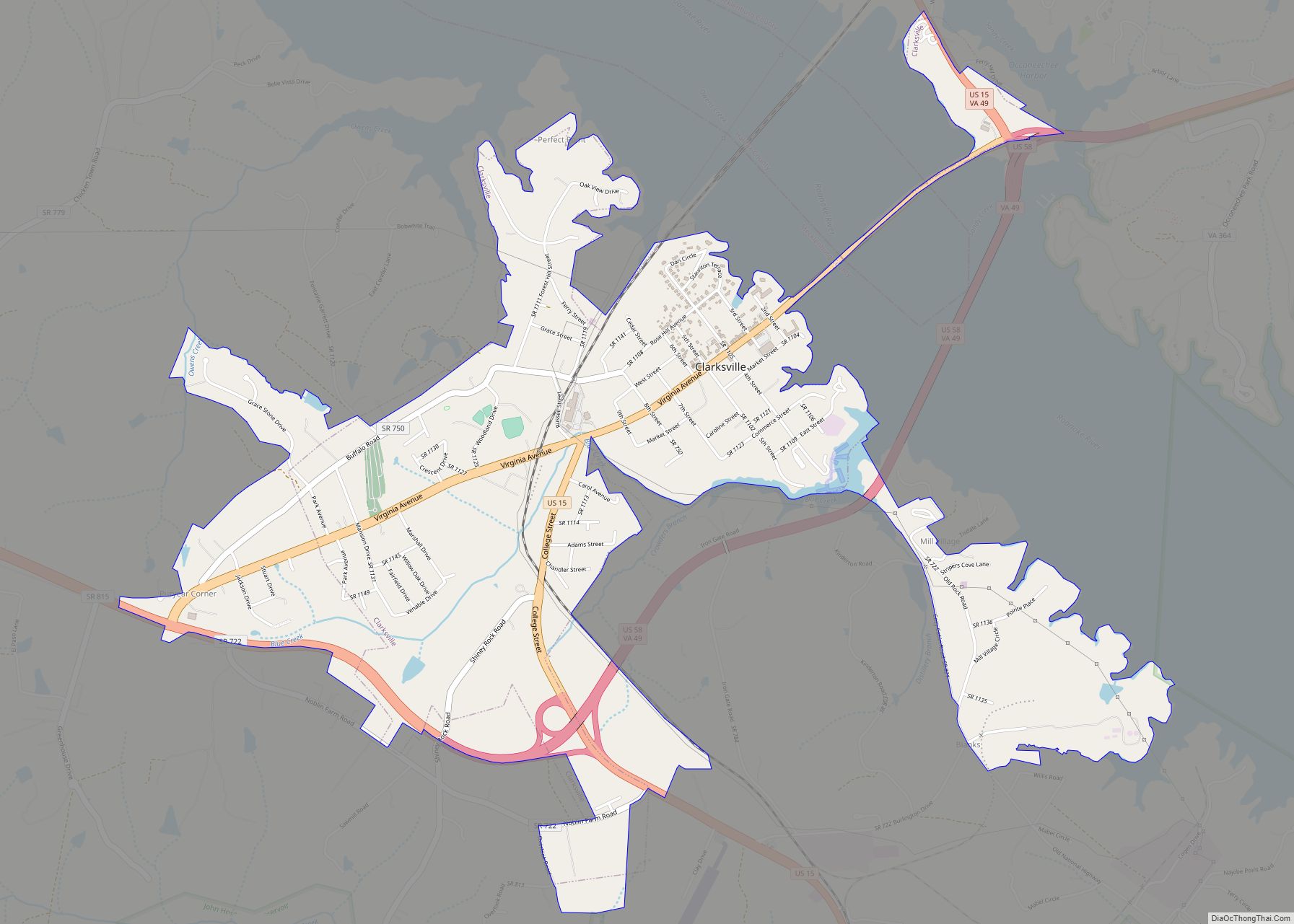
Map of Templeton CDP, Virginia

Map of Templeton CDP, Virginia

Templeton is a census-designated place in Prince George County, Virginia. The population as of the 2010 Census was 431. Templeton is located along Interstate 95 at Exit 41 where US 301, and Virginia State Routes 35 and 156 converge. Templeton CDP overview: Name: Templeton CDP LSAD Code: 57 LSAD Description: CDP (suffix) State: Virginia County: … Read more

Map of Temperanceville CDP

Map of Temperanceville CDP

Temperanceville is a census-designated place (CDP) in Accomack County, Virginia, United States. It was first listed as a CDP in 2010. As of the 2020 census, it had a population of 308. Temperanceville was originally built up chiefly by Quakers. It lies at an elevation of 43 feet. Temperanceville CDP overview: Name: Temperanceville CDP LSAD … Read more

Map of Tazewell town, Virginia

Map of Tazewell town, Virginia

Tazewell (/tæz.wɛl/) is a town in Tazewell County, Virginia, United States. The population was 4,627 at the 2010 census. It is part of the Bluefield, WV-VA micropolitan area, which has a population of 107,578. It is the county seat of Tazewell County. Tazewell town overview: Name: Tazewell town LSAD Code: 43 LSAD Description: town (suffix) … Read more

Map of Troutdale town, Virginia

Map of Troutdale town, Virginia

Troutdale is a town in Grayson County, Virginia, United States. The population was 140 at the 2020 census. Troutdale town overview: Name: Troutdale town LSAD Code: 43 LSAD Description: town (suffix) State: Virginia County: Grayson County Elevation: 3,127 ft (953 m) Total Area: 3.13 sq mi (8.10 km²) Land Area: 3.12 sq mi (8.09 km²) Water Area: 0.00 sq mi (0.00 km²) Total Population: 140 Population … Read more

Map of Triangle CDP

Map of Triangle CDP

Triangle is a census-designated place (CDP) in Prince William County, Virginia, United States. The population was 8,188 at the 2010 census. It is bounded to the south by the Marine Corps Base Quantico, which surrounds the town of Quantico. Triangle CDP overview: Name: Triangle CDP LSAD Code: 57 LSAD Description: CDP (suffix) State: Virginia County: … Read more

Map of Toms Brook town

Map of Toms Brook town

Toms Brook is a town in Shenandoah County, Virginia, United States. The population was 258 at the 2010 census. Toms Brook town overview: Name: Toms Brook town LSAD Code: 43 LSAD Description: town (suffix) State: Virginia County: Shenandoah County Elevation: 702 ft (214 m) Total Area: 0.13 sq mi (0.33 km²) Land Area: 0.13 sq mi (0.33 km²) Water Area: 0.00 sq mi (0.00 km²) Total … Read more

Map of Timberville town

Map of Timberville town

Timberville is a town in Rockingham County, Virginia, United States. The population was 2,522 at the 2010 census, which was a significant increase from the 1,739 reported in the 2000 census. It is part of the Harrisonburg Metropolitan Statistical Area. Timberville town overview: Name: Timberville town LSAD Code: 43 LSAD Description: town (suffix) State: Virginia … Read more

Map of Timberlake CDP, Virginia

Map of Timberlake CDP, Virginia

Timberlake CDP overview: Name: Timberlake CDP LSAD Code: 57 LSAD Description: CDP (suffix) State: Virginia County: Campbell County FIPS code: 5178688 Online Interactive Map Timberlake online map. Source: Basemap layers from Google Map, Open Street Map (OSM), Arcgisonline, Wmflabs. Boundary Data from Database of Global Administrative Areas. Timberlake location map. Where is Timberlake CDP? Timberlake … Read more

Map of Thynedale CDP

Map of Thynedale CDP

Thynedale is a census-designated place in Mecklenburg County, Virginia, just north of Chase City. The population as of the 2010 Census was 197. Thynedale CDP overview: Name: Thynedale CDP LSAD Code: 57 LSAD Description: CDP (suffix) State: Virginia County: Mecklenburg County Total Area: 197 ZIP code: 23924 FIPS code: 5178532 GNISfeature ID: 2584930 Online Interactive … Read more

Map of The Plains town, Virginia

Map of The Plains town, Virginia

The Plains is a town in Fauquier County, Virginia, United States. The population was 245 as of the 2020 census, up from 217 at the 2010 census. It is centered on the intersection of VA 55 (John Marshall Highway) and VA 245 (Old Tavern Road). The town of The Plains is situated off I-66. As … Read more

Map of Urbanna town

Map of Urbanna town

Urbanna is a town in Middlesex County, Virginia, United States. Urbanna means “City of Anne” and was named in honor of England’s Queen Anne. The population was 476 at the 2010 census. Urbanna town overview: Name: Urbanna town LSAD Code: 43 LSAD Description: town (suffix) State: Virginia County: Middlesex County Elevation: 20 ft (6 m) Total Area: … Read more

Map of University of Virginia CDP

Map of University of Virginia CDP

University of Virginia is a census-designated place in Albemarle County, Virginia. The population as of the 2010 Census was 7,704. University of Virginia CDP overview: Name: University of Virginia CDP LSAD Code: 57 LSAD Description: CDP (suffix) State: Virginia County: Albemarle County Total Area: 7,909 ZIP code: 22903, 22904 FIPS code: 5180165 GNISfeature ID: 2629042 … Read more