Map of Dryden CDP, Virginia
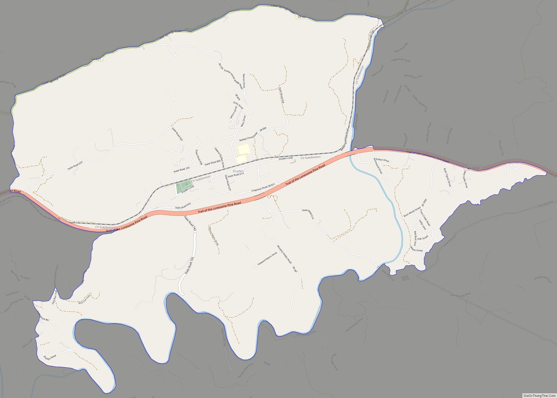
Dryden is an unincorporated community and census-designated place (CDP) in Lee County, Virginia, United States. The population was 1,208 at the 2010 census. Dryden CDP overview: Name: Dryden CDP LSAD Code: 57 LSAD Description: CDP (suffix) State: Virginia County: Lee County Elevation: 1,440 ft (439 m) Total Area: 7.17 sq mi (18.57 km²) Land Area: 7.06 sq mi (18.29 km²) Water Area: 0.11 sq mi ... Read more
Map of Dryden CDP, Virginia
Map of East Highland Park CDP
East Highland Park is a census-designated place (CDP) in Henrico County, Virginia, in the United States. The population was 15,131 at the 2020 census. East Highland Park CDP overview: Name: East Highland Park CDP LSAD Code: 57 LSAD Description: CDP (suffix) State: Virginia County: Henrico County Elevation: 200 ft (61 m) Total Area: 9.0 sq mi (23.3 km²) Land Area: ... Read more
Map of East Highland Park CDP
Map of Dungannon town
Dungannon is a town in Scott County, Virginia, United States. The population was 332 at the 2010 census. It was named after the town of Dungannon in County Tyrone, Northern Ireland. Dungannon is part of the Kingsport–Bristol (TN)–Bristol (VA) Metropolitan Statistical Area, which is a component of the Johnson City–Kingsport–Bristol, TN-VA Combined Statistical Area – ... Read more
Map of Dungannon town
Map of Dumbarton CDP
Dumbarton is a census-designated place (CDP) in Henrico County, Virginia, United States. The population was 7,879 at the 2010 census. Dumbarton CDP overview: Name: Dumbarton CDP LSAD Code: 57 LSAD Description: CDP (suffix) State: Virginia County: Henrico County Elevation: 200 ft (61 m) Total Area: 1.9 sq mi (4.9 km²) Land Area: 1.9 sq mi (4.9 km²) Water Area: 0.0 sq mi (0.0 km²) Total Population: ... Read more
Map of Dumbarton CDP
Map of Dulles Town Center CDP
Dulles Town Center is a census-designated place (CDP) in Loudoun County, Virginia, United States. It is located about 7 miles (11 km) north of Washington Dulles International Airport. The CDP is the location of the Dulles Town Center shopping mall, for which it is named. The United States Postal Service considers Dulles Town Center to be ... Read more
Map of Dulles Town Center CDP
Map of Esmont CDP
Esmont is a census-designated place (CDP) in Albemarle County, Virginia, United States. The population as of the 2020 Census was 491. Esmont, Guthrie Hall, and Mountain Grove are listed the National Register of Historic Places. Esmont CDP overview: Name: Esmont CDP LSAD Code: 57 LSAD Description: CDP (suffix) State: Virginia County: Albemarle County FIPS code: ... Read more
Map of Esmont CDP
Map of Enon CDP, Virginia
Enon is a census-designated place (CDP) in Chesterfield County, Virginia, United States, just east of Chester. The population as of the 2010 Census was 3,466. It has the zip code 23836 and GPS coordinates 37.3504000, −77.3254000. Enon CDP overview: Name: Enon CDP LSAD Code: 57 LSAD Description: CDP (suffix) State: Virginia County: Chesterfield County FIPS ... Read more
Map of Enon CDP, Virginia
Map of Elkton town, Virginia
Elkton (formerly Conrad’s Store) is an incorporated town in Rockingham County, Virginia, United States. It is included in the Harrisonburg Metropolitan Statistical Area. The population was 2,762 at the 2010 census. Elkton was named for the Elk Run stream. It is located along the south fork of the Shenandoah River at the intersections of east-west ... Read more
Map of Elkton town, Virginia
Map of Ferrum CDP
Ferrum CDP overview: Name: Ferrum CDP LSAD Code: 57 LSAD Description: CDP (suffix) State: Virginia County: Franklin County FIPS code: 5127712 Online Interactive Map Ferrum online map. Source: Basemap layers from Google Map, Open Street Map (OSM), Arcgisonline, Wmflabs. Boundary Data from Database of Global Administrative Areas. Ferrum location map. Where is Ferrum CDP? Ferrum ... Read more
Map of Ferrum CDP
Map of Fishersville CDP
Fishersville CDP overview: Name: Fishersville CDP LSAD Code: 57 LSAD Description: CDP (suffix) State: Virginia County: Augusta County FIPS code: 5127968 Online Interactive Map Fishersville online map. Source: Basemap layers from Google Map, Open Street Map (OSM), Arcgisonline, Wmflabs. Boundary Data from Database of Global Administrative Areas. Fishersville location map. Where is Fishersville CDP? Fishersville ... Read more
Map of Fishersville CDP
Map of Glade Spring town
Glade Spring is a town in Washington County, Virginia, United States. The population was 1,456 at the 2010 census. It is part of the Kingsport–Bristol (TN)–Bristol (VA) Metropolitan Statistical Area, which is a component of the Johnson City–Kingsport–Bristol, TN-VA Combined Statistical Area – commonly known as the “Tri-Cities” region. Glade Spring town overview: Name: Glade ... Read more
Map of Glade Spring town
Map of Gordonsville town, Virginia
Gordonsville is a town in Orange County in the Commonwealth of Virginia in the United States. Located about 19 miles northeast of Charlottesville and 65 miles northwest of Richmond, the population was 1,496 at the 2010 census. The town celebrated its bicentennial in 2013, two hundred years after local innkeeper Nathaniel Gordon was appointed the ... Read more
Map of Gordonsville town, Virginia