Dulles Town Center is a census-designated place (CDP) in Loudoun County, Virginia, United States. It is located about 7 miles (11 km) north of Washington Dulles International Airport. The CDP is the location of the Dulles Town Center shopping mall, for which it is named. The United States Postal Service considers Dulles Town Center to be a subsection of Dulles, which is itself a subsection of Sterling; none of these locations is an incorporated municipality.
The population as of the 2010 United States Census was 4,601.
| Name: | Dulles Town Center CDP |
|---|---|
| LSAD Code: | 57 |
| LSAD Description: | CDP (suffix) |
| State: | Virginia |
| County: | Loudoun County |
| Elevation: | 310 ft (90 m) |
| Total Area: | 2.42 sq mi (6.28 km²) |
| Land Area: | 2.40 sq mi (6.22 km²) |
| Water Area: | 0.02 sq mi (0.06 km²) |
| Total Population: | 4,601 |
| Population Density: | 1,916/sq mi (739.7/km²) |
| ZIP code: | 20166 (Sterling) |
| Area code: | 703 and 571 |
| FIPS code: | 5123732 |
| GNISfeature ID: | 2584839 |
Online Interactive Map
Click on ![]() to view map in "full screen" mode.
to view map in "full screen" mode.
Dulles Town Center location map. Where is Dulles Town Center CDP?


History
In December 1987, Loudoun County officials approved the jurisdiction’s first regional shopping mall. The mall was originally planned to be named the “Windmill Regional Shopping Center” but was later renamed to “Dulles Town Center” in 1988. The original expected opening was set for 1993. Dulles Town Center’s developer was Lerner Enterprises.
The mall was put on hold until 1994 due to the downturn in the local economy. In March of that year the mall announced it would start construction that spring with plans to be open 1996. With further delays, it wasn’t until the summer of 1996 that Dulles Town Center broke ground. The mall opened its first two anchor stores (Hecht’s and Lord & Taylor) on November 18, 1998. The ribbon-cutting ceremony for Dulles Town Center took place on August 12, 1999.
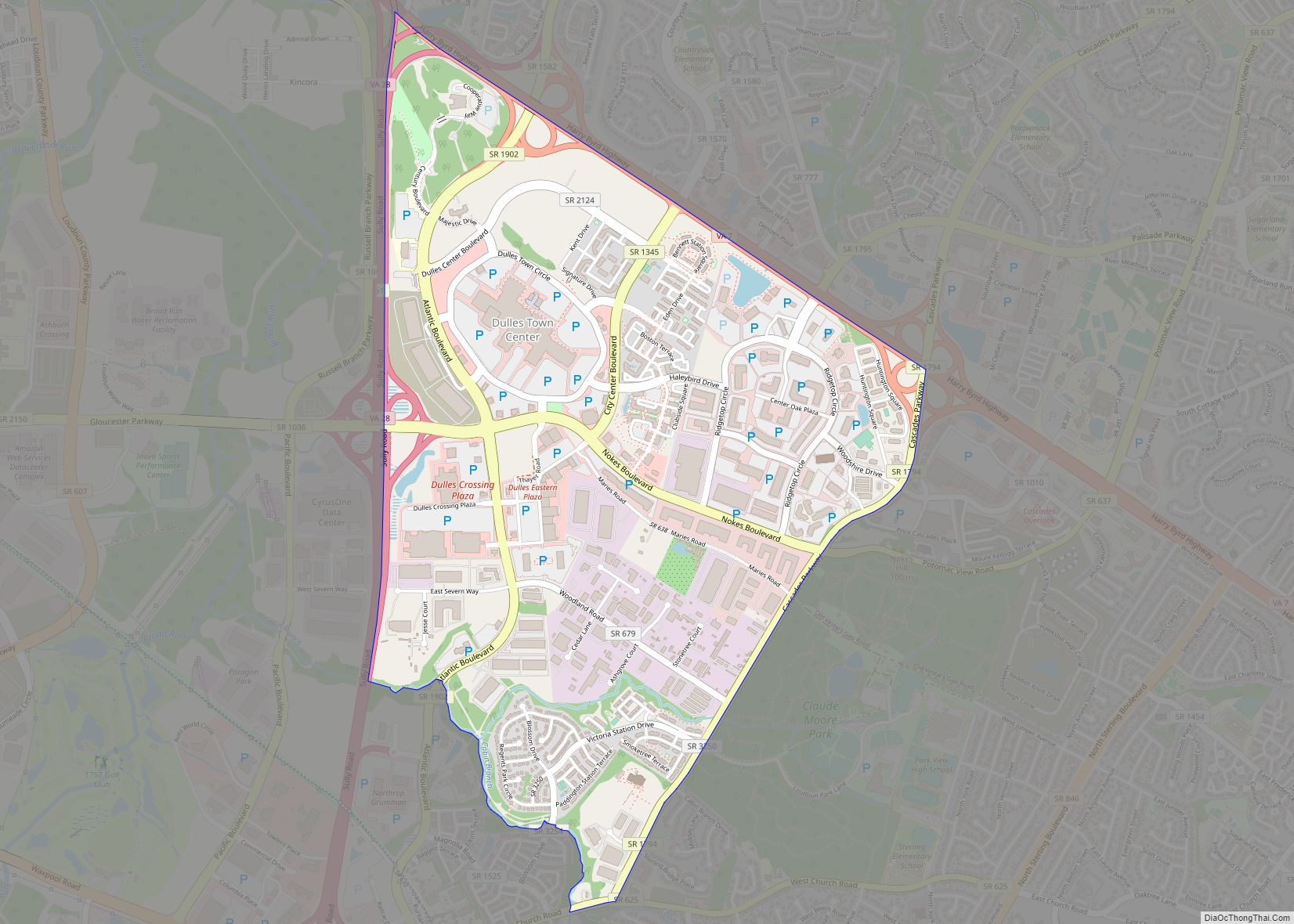
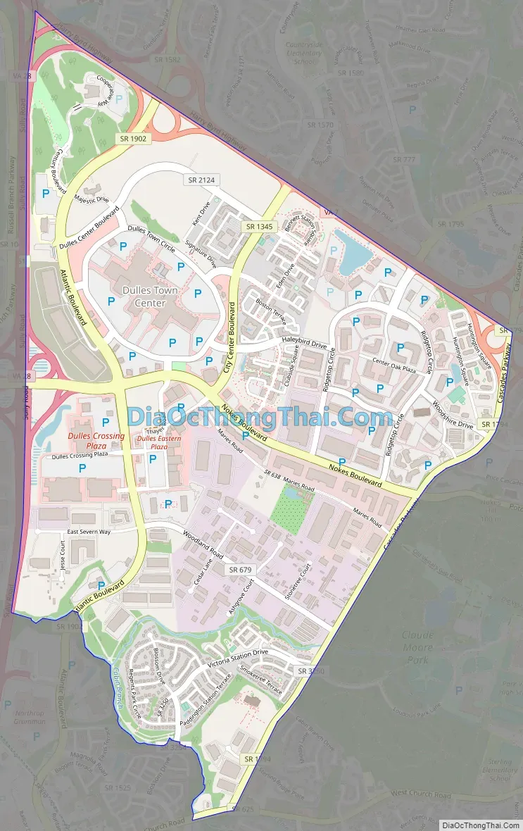
Dulles Town Center Road Map
Dulles Town Center city Satellite Map

Geography
The Dulles Town Center CDP is in eastern Loudoun County. It is bordered to the north by Virginia State Route 7 (Leesburg Pike) and to the west by Virginia State Route 28. Neighboring communities are Sterling to the south and east, Ashburn and Kincora to the west, and Countryside and Cascades to the north. Dulles Town Center is 10 miles (16 km) southeast of Leesburg, the Loudoun county seat, and 27 miles (43 km) northwest of downtown Washington, D.C.
According to the U.S. Census Bureau, the CDP has a total area of 2.4 square miles (6.3 km), of which 0.02 square miles (0.06 km), or 0.94%, are water. The community drains westward to Broad Run, a north-flowing tributary of the Potomac River.
See also
Map of Virginia State and its subdivision:- Accomack
- Albemarle
- Alexandria
- Alleghany
- Amelia
- Amherst
- Appomattox
- Arlington
- Augusta
- Bath
- Bedford
- Bedford City
- Bland
- Botetourt
- Bristol
- Brunswick
- Buchanan
- Buckingham
- Buena Vista
- Campbell
- Caroline
- Carroll
- Charles City
- Charlotte
- Charlottesville
- Chesapeake
- Chesterfield
- Clarke
- Clifton Forge City
- Colonial Heights
- Covington
- Craig
- Culpeper
- Cumberland
- Danville
- Dickenson
- Dinwiddie
- Emporia
- Essex
- Fairfax
- Fairfax City
- Falls Church
- Fauquier
- Floyd
- Fluvanna
- Franklin
- Frederick
- Fredericksburg
- Galax
- Giles
- Gloucester
- Goochland
- Grayson
- Greene
- Greensville
- Halifax
- Hampton
- Hanover
- Harrisonburg
- Henrico
- Henry
- Highland
- Hopewell
- Isle of Wight
- James City
- King and Queen
- King George
- King William
- Lancaster
- Lee
- Lexington
- Loudoun
- Louisa
- Lunenburg
- Lynchburg
- Madison
- Manassas
- Manassas Park
- Martinsville
- Mathews
- Mecklenburg
- Middlesex
- Montgomery
- Nelson
- New Kent
- Newport News
- Norfolk
- Northampton
- Northumberland
- Norton
- Nottoway
- Orange
- Page
- Patrick
- Petersburg
- Pittsylvania
- Poquoson
- Portsmouth
- Powhatan
- Prince Edward
- Prince George
- Prince William
- Pulaski
- Radford
- Rappahannock
- Richmond
- Roanoke
- Roanoke City
- Rockbridge
- Rockingham
- Russell
- Salem
- Scott
- Shenandoah
- Smyth
- Southampton
- Spotsylvania
- Stafford
- Staunton
- Suffolk
- Surry
- Sussex
- Tazewell
- Virginia Beach
- Warren
- Washington
- Waynesboro
- Westmoreland
- Williamsburg
- Winchester
- Wise
- Wythe
- York
- Alabama
- Alaska
- Arizona
- Arkansas
- California
- Colorado
- Connecticut
- Delaware
- District of Columbia
- Florida
- Georgia
- Hawaii
- Idaho
- Illinois
- Indiana
- Iowa
- Kansas
- Kentucky
- Louisiana
- Maine
- Maryland
- Massachusetts
- Michigan
- Minnesota
- Mississippi
- Missouri
- Montana
- Nebraska
- Nevada
- New Hampshire
- New Jersey
- New Mexico
- New York
- North Carolina
- North Dakota
- Ohio
- Oklahoma
- Oregon
- Pennsylvania
- Rhode Island
- South Carolina
- South Dakota
- Tennessee
- Texas
- Utah
- Vermont
- Virginia
- Washington
- West Virginia
- Wisconsin
- Wyoming