Map of Plum Creek CDP
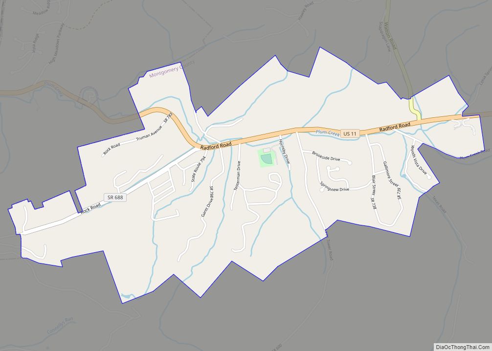
Plum Creek is a census-designated place in Montgomery County, Virginia, United States, just east of Radford. The population as of the 2010 Census was 1,524. Plum Creek CDP overview: Name: Plum Creek CDP LSAD Code: 57 LSAD Description: CDP (suffix) State: Virginia County: Montgomery County Total Area: 1,524 ZIP code: 24073 FIPS code: 5163190 GNISfeature ... Read more
Map of Plum Creek CDP
Map of Raven CDP
Raven is a census-designated place (CDP) in Russell and Tazewell counties in the U.S. state of Virginia. The population was 2,270 at the 2010 census. Raven CDP overview: Name: Raven CDP LSAD Code: 57 LSAD Description: CDP (suffix) State: Virginia County: Russell County, Tazewell County Elevation: 1,913 ft (583 m) Total Area: 6.8 sq mi (17.7 km²) Land Area: 6.8 sq mi ... Read more
Map of Raven CDP
Map of Remington town, Virginia
Remington is a small incorporated town in Fauquier County, Virginia, United States. The population was 598 at the 2010 census. It is near the highways, U.S. Route 15, U.S. Route 17, U.S. Route 29, and Virginia State Route 28. Remington is less than a mile northeast of the Culpeper County line. Remington town overview: Name: ... Read more
Map of Remington town, Virginia
Map of Riverdale CDP, Virginia
Riverdale is a census-designated place in Halifax County, Virginia, United States. The population as of the 2010 census was 956. Riverdale CDP overview: Name: Riverdale CDP LSAD Code: 57 LSAD Description: CDP (suffix) State: Virginia County: Halifax County Elevation: 406 ft (124 m) Total Area: 8.3 sq mi (21.5 km²) Land Area: 8.1 sq mi (21.1 km²) Water Area: 0.2 sq mi (0.4 km²) Total Population: ... Read more
Map of Riverdale CDP, Virginia
Map of Saltville town
Saltville is a town in Smyth and Washington counties in the U.S. state of Virginia. The population was 2,077 at the 2010 census. It is part of the Kingsport–Bristol (TN)–Bristol (VA) Metropolitan Statistical Area, which is a component of the Johnson City–Kingsport–Bristol, TN-VA Combined Statistical Area – commonly known as the “Tri-Cities” region. Saltville town ... Read more
Map of Saltville town
Map of Scottsburg town, Virginia
Scottsburg is a town in Halifax County, Virginia, United States. The population was 119 at the 2010 census, down from 145 at the 2000 census. Scottsburg town overview: Name: Scottsburg town LSAD Code: 43 LSAD Description: town (suffix) State: Virginia County: Halifax County Elevation: 374 ft (114 m) Total Area: 0.74 sq mi (1.93 km²) Land Area: 0.74 sq mi (1.92 km²) Water ... Read more
Map of Scottsburg town, Virginia
Map of Short Pump CDP
Short Pump is a census-designated place (CDP) in Henrico County, Virginia, United States. It is a suburb of Richmond, Virginia. The population was 30,626 at the 2020 census. The original village of Short Pump was located at the intersection of Three Chopt Road (formerly known as Three Notched Trail), Richmond Turnpike and Pouncey Tract Road. ... Read more
Map of Short Pump CDP
Map of St. Paul town, Virginia
St. Paul is a town in Russell and Wise counties in the U.S. state of Virginia. The population was 970 at the 2010 census. Virginia City Hybrid Energy Center, which powers 150,000 homes, is located in St. Paul. St. Paul town overview: Name: St. Paul town LSAD Code: 43 LSAD Description: town (suffix) State: Virginia ... Read more
Map of St. Paul town, Virginia
Map of The Plains town, Virginia
The Plains is a town in Fauquier County, Virginia, United States. The population was 245 as of the 2020 census, up from 217 at the 2010 census. It is centered on the intersection of VA 55 (John Marshall Highway) and VA 245 (Old Tavern Road). The town of The Plains is situated off I-66. As ... Read more
Map of The Plains town, Virginia