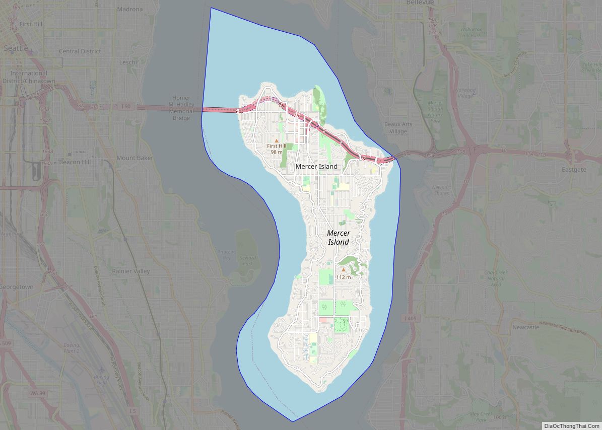
Map of Gleed CDP

Map of Gleed CDP

Gleed is a census-designated place (CDP) in Yakima County, Washington, United States. The population was 2,906 at the 2010 census. Gleed CDP overview: Name: Gleed CDP LSAD Code: 57 LSAD Description: CDP (suffix) State: Washington County: Yakima County Elevation: 1,253 ft (382 m) Total Area: 5.4 sq mi (13.9 km²) Land Area: 5.4 sq mi (13.9 km²) Water Area: 0.0 sq mi (0.0 km²) Total Population: … Read more

Map of Glacier CDP

Map of Glacier CDP

Glacier is a census-designated place in the North Fork Nooksack River Valley, at an elevation of 906 ft., just 10 miles northwest of the Mount Baker Summit towering nearly 10,000 ft above it, in Whatcom County, Washington, United States. The population was 211 at the 2010 census. Glacier is the community closest to Mt. Baker, … Read more

Map of Gig Harbor city

Map of Gig Harbor city

Gig Harbor is the name of both a bay on Puget Sound and a city on its shore in Pierce County, Washington,. The population was 12,029 at the 2020 census. Gig Harbor bills itself as “the Maritime City” and maintains a strong connection to its maritime heritage. Due to its close access to several state … Read more

Map of George city, Washington

Map of George city, Washington

George is a city in Grant County, Washington, United States. The population was 809 at the 2020 census. The “humorous homage” to President George Washington has landed George, Washington on lists of unusual place names. The city is known for being near the Gorge Amphitheatre, sometimes called “The Gorge at George”. The Gorge Amphitheatre was … Read more

Map of Grand Coulee city

Map of Grand Coulee city

Grand Coulee is a city in Grant County, Washington, United States. The population was 972 at the 2020 census. Grand Coulee city overview: Name: Grand Coulee city LSAD Code: 25 LSAD Description: city (suffix) State: Washington County: Grant County Elevation: 1,483 ft (452 m) Total Area: 1.36 sq mi (3.53 km²) Land Area: 1.26 sq mi (3.25 km²) Water Area: 0.11 sq mi (0.28 km²) Total … Read more

Map of Graham CDP, Washington

Map of Graham CDP, Washington

Graham is a census-designated place (CDP) in Pierce County, Washington, United States. It is located 16 miles southeast of Tacoma. The population was 23,491 at the 2010 census and grew to 32,658 at the 2020 census. Graham CDP overview: Name: Graham CDP LSAD Code: 57 LSAD Description: CDP (suffix) State: Washington County: Pierce County Elevation: … Read more

Map of Gorst CDP

Map of Gorst CDP

Gorst is a census-designated place (CDP) at the head of Sinclair Inlet in Kitsap County, Washington, United States. The population was 592 at the 2010 census. Gorst, located on the shores of Puget Sound, is primarily a town consisting of stores, auto dealerships and espresso stands. A residential area, located west of the water along … Read more

Map of Goldendale city

Map of Goldendale city

Goldendale is a city and county seat of Klickitat County, Washington, United States, near the Columbia River Gorge. The population within city limits was 3,760 at the 2000 census and 3,407 at the 2010 census, a 9.4% decrease. It is situated in a primarily agricultural area and is also near Goldendale Observatory State Park. The … Read more

Map of Gold Bar city

Map of Gold Bar city

Gold Bar is a city in Snohomish County, Washington, United States. It is located on the Skykomish River between Sultan and Index, connected by U.S. Route 2. The population was 2,403 at the 2020 census. Gold Bar city overview: Name: Gold Bar city LSAD Code: 25 LSAD Description: city (suffix) State: Washington County: Snohomish County … Read more

Map of Glenwood CDP, Washington

Map of Glenwood CDP, Washington

Glenwood CDP overview: Name: Glenwood CDP LSAD Code: 57 LSAD Description: CDP (suffix) State: Washington FIPS code: 5327225 Online Interactive Map Glenwood online map. Source: Basemap layers from Google Map, Open Street Map (OSM), Arcgisonline, Wmflabs. Boundary Data from Database of Global Administrative Areas. Glenwood location map. Where is Glenwood CDP? Glenwood Road Map Glenwood … Read more

Map of Hamilton town, Washington

Map of Hamilton town, Washington

Hamilton town overview: Name: Hamilton town LSAD Code: 43 LSAD Description: town (suffix) State: Washington County: Skagit County FIPS code: 5329255 Online Interactive Map Hamilton online map. Source: Basemap layers from Google Map, Open Street Map (OSM), Arcgisonline, Wmflabs. Boundary Data from Database of Global Administrative Areas. Hamilton location map. Where is Hamilton town? Hamilton … Read more

Map of Greenwater CDP

Map of Greenwater CDP

Greenwater is a census-designated place (CDP) in the northwest United States in Pierce County, Washington. Southeast of Seattle, the population was 67 at the 2010 census, down from 91 in 2000. Based on per capita income, Greenwater ranks 17th of 522 areas in the state of Washington to be ranked, and is the highest in … Read more