Map of Royal City
Royal City is a city in Grant County, Washington, United States. The population was 1,776 at the 2020 census. Royal City city overview: Name: Royal City city LSAD Code: 25 LSAD Description: city (suffix) State: Washington County: Grant County Elevation: 1,063 ft (324 m) Total Area: 1.16 sq mi (3.01 km²) Land Area: 1.16 sq mi (3.01 km²) Water Area: 0.00 sq mi (0.00 km²) Total ... Read more
Map of Royal City
Map of Roy city, Washington
Roy is a city in Pierce County, Washington, United States. The population was 816 at the 2020 census. Roy city overview: Name: Roy city LSAD Code: 25 LSAD Description: city (suffix) State: Washington County: Pierce County Incorporated: January 16, 1908 Elevation: 322 ft (98 m) Total Area: 0.48 sq mi (1.25 km²) Land Area: 0.48 sq mi (1.25 km²) Water Area: 0.00 sq mi (0.00 km²) ... Read more
Map of Roy city, Washington
Map of Shelton city, Washington
Shelton is a city in and the county seat of Mason County, Washington, United States. Shelton is the westernmost city on Puget Sound. The population was 10,371 at the 2020 census. Shelton has a council–manager form of government and was the last city in Washington to use a mayor–commission form of government. Shelton city overview: ... Read more
Map of Shelton city, Washington
Map of Shadow Lake CDP
Shadow Lake is a census-designated place (CDP) in King County, Washington, United States. The population was 2,262 at the 2010 census. Shadow Lake CDP overview: Name: Shadow Lake CDP LSAD Code: 57 LSAD Description: CDP (suffix) State: Washington County: King County Elevation: 550 ft (170 m) Total Area: 5.33 sq mi (13.81 km²) Land Area: 5.19 sq mi (13.44 km²) Water Area: 0.14 sq mi ... Read more
Map of Shadow Lake CDP
Map of Rosedale CDP, Washington
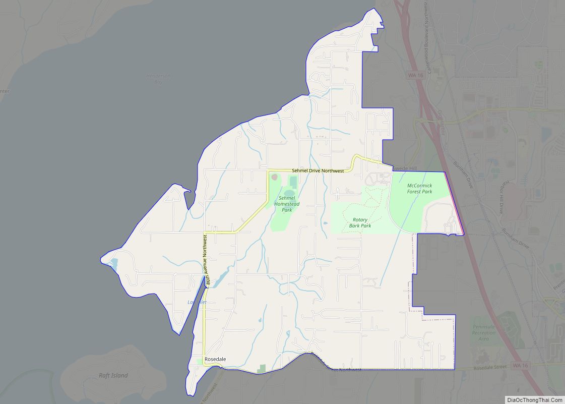
Rosedale is a census-designated place (CDP) located in Pierce County, Washington. A post office called Rosedale was established in 1887, and remained in operation until 1918. The community was named for roses near the original town site. Rosedale CDP overview: Name: Rosedale CDP LSAD Code: 57 LSAD Description: CDP (suffix) State: Washington County: Pierce County ... Read more
Map of Rosedale CDP, Washington
Map of Sequim city
Sequim (/ˈskwɪm/ (listen) SKWIM) is a city in Clallam County, Washington, United States. It is located along the Dungeness River near the base of the Olympic Mountains. The 2020 census counted a population of 8,018, with an estimated population in 2021 of 8,241. Sequim lies within the rain shadow of the Olympic Mountains and receives, ... Read more
Map of Sequim city
Map of Rosburg CDP
Rosburg is a Census-designated place (CDP) in Wahkiakum County, Washington, United States. Rosburg is located on the Grays River near Washington State Route 4, 15 miles (24 km) northwest of Cathlamet. Rosburg has a post office with ZIP code 98643. The CDP includes the communities of Eden and Oneida. Christian Rosburg, the town’s first postmaster, named ... Read more
Map of Rosburg CDP
Map of Selah city
Selah is a city in Yakima County, Washington, United States. The population was 8,153 at the 2020 census. Selah city overview: Name: Selah city LSAD Code: 25 LSAD Description: city (suffix) State: Washington County: Yakima County Founded: 1871 Incorporated: March 17, 1919 Elevation: 1,119 ft (341 m) Total Area: 4.64 sq mi (12.01 km²) Land Area: 4.58 sq mi (11.86 km²) Water Area: ... Read more
Map of Selah city
Map of Rosalia town, Washington
Rosalia town overview: Name: Rosalia town LSAD Code: 43 LSAD Description: town (suffix) State: Washington County: Whitman County FIPS code: 5359775 Online Interactive Map Rosalia online map. Source: Basemap layers from Google Map, Open Street Map (OSM), Arcgisonline, Wmflabs. Boundary Data from Database of Global Administrative Areas. Rosalia location map. Where is Rosalia town? Rosalia ... Read more
Map of Rosalia town, Washington
Map of Sekiu CDP
Sekiu is an unincorporated community and census-designated place in Clallam County, Washington, United States. As of the 2010 census it had a population of 27. Overlooking the west side of Clallam Bay and the Strait of Juan de Fuca, it is twinned with the community of Clallam Bay, on the east side of the bay. ... Read more
Map of Sekiu CDP
Map of Sedro-Woolley city
Sedro-Woolley is a city in Skagit County, Washington, United States. It is part of the Mount Vernon–Anacortes, Washington Metropolitan Statistical Area and had a population of 12,421 at the 2020 census. The city is home to North Cascades National Park. Sedro-Woolley city overview: Name: Sedro-Woolley city LSAD Code: 25 LSAD Description: city (suffix) State: Washington ... Read more
Map of Sedro-Woolley city
Map of SeaTac city
SeaTac /ˈsiːtæk/ is a city in southern King County, Washington, United States. The city is an inner-ring suburb of Seattle and part of the Seattle metropolitan area. The name “SeaTac” is derived from the Seattle–Tacoma International Airport, itself a portmanteau of Seattle and Tacoma. The city of SeaTac is 10 square miles (26 km) in area ... Read more
Map of SeaTac city