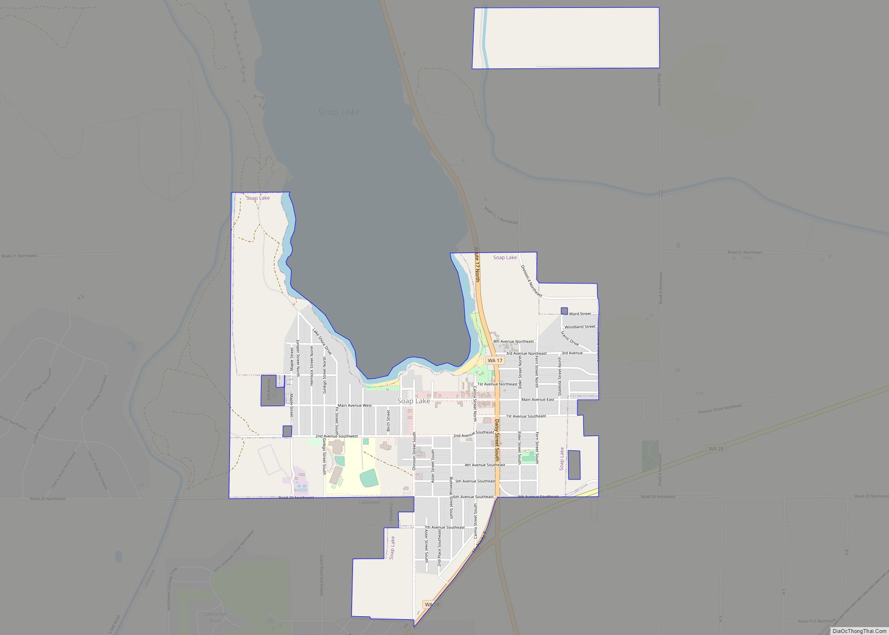
Southworth is an unincorporated community and census-designated place (CDP) on Puget Sound in Kitsap County, Washington, United States. It is best known for being the west end of the Fauntleroy-Vashon Island-Southworth Washington State Ferries run. Landmarks include Southworth Grocery, a US Post Office, ferry terminal, clay cliffs and a private beach on the point. Next ... Read more
Washington Cities and Places
Silver Firs is a census-designated place (CDP) in Snohomish County, Washington, United States. The population was 22,174 at the 2020 census. It lies northeast of the city of Mill Creek. Silver Firs is one of two CDPs that were created out of the former Seattle Hill-Silver Firs CDP in 2010, the other being Eastmont. Silver ... Read more
Silvana is a rural community and census-designated place (CDP) in Snohomish County, Washington, United States. Its population was 90 at the 2010 census. Silvana CDP overview: Name: Silvana CDP LSAD Code: 57 LSAD Description: CDP (suffix) State: Washington County: Snohomish County Elevation: 30 ft (9 m) Total Area: 1.5 sq mi (4.0 km²) Land Area: 1.5 sq mi (4.0 km²) Water Area: 0.0 sq mi ... Read more
South Prairie town overview: Name: South Prairie town LSAD Code: 43 LSAD Description: town (suffix) State: Washington County: Pierce County FIPS code: 5366045 Online Interactive Map South Prairie online map. Source: Basemap layers from Google Map, Open Street Map (OSM), Arcgisonline, Wmflabs. Boundary Data from Database of Global Administrative Areas. South Prairie location map. Where ... Read more
Shoreline is a city in King County, Washington, United States. It is located between the city limits of Seattle and the Snohomish County border, approximately 9 miles (14 km) north of Downtown Seattle. As of the 2020 census, the population of Shoreline was 58,608, making it the 22nd largest city in the state. Based on per ... Read more
Sudden Valley is a census-designated place (CDP) just outside of Bellingham in Whatcom County, Washington. Sudden Valley is the second-largest homeowner association in western Washington, with over 7,000 residents. There are eleven neighborhood parks, miles of hiking trails in woodlands and along Lake Whatcom, beaches, two pools, sports fields, tennis courts, a basketball court, a ... Read more
Stevenson is a city in the Columbia River Gorge National Scenic Area along the Columbia River in Skamania County, Washington, United States. It is the county seat of Skamania County and home to the Skamania County Court House and Sheriff’s Office. The population was 1,465 at the 2010 census, a 22% increase over 2000. Stevenson ... Read more
Steptoe is a small unincorporated rural town in Whitman County, Washington, United States. Steptoe is 11 miles north of the county seat, Colfax and is 43 miles south of Spokane. A post office called Steptoe was established in 1875. The community is named after Colonel Edward Steptoe for a battle located north of Steptoe near ... Read more
Steilacoom town overview: Name: Steilacoom town LSAD Code: 43 LSAD Description: town (suffix) State: Washington County: Pierce County FIPS code: 5367770 Online Interactive Map Steilacoom online map. Source: Basemap layers from Google Map, Open Street Map (OSM), Arcgisonline, Wmflabs. Boundary Data from Database of Global Administrative Areas. Steilacoom location map. Where is Steilacoom town? Steilacoom ... Read more
Startup is a census-designated place (CDP) in Snohomish County, Washington, United States. The population was 676 at the 2010 census. Startup CDP overview: Name: Startup CDP LSAD Code: 57 LSAD Description: CDP (suffix) State: Washington County: Snohomish County Elevation: 148 ft (45 m) Total Area: 4.0 sq mi (10.3 km²) Land Area: 3.9 sq mi (10.1 km²) Water Area: 0.1 sq mi (0.2 km²) Total Population: ... Read more
Starbuck town overview: Name: Starbuck town LSAD Code: 43 LSAD Description: town (suffix) State: Washington County: Columbia County FIPS code: 5367490 Online Interactive Map Starbuck online map. Source: Basemap layers from Google Map, Open Street Map (OSM), Arcgisonline, Wmflabs. Boundary Data from Database of Global Administrative Areas. Starbuck location map. Where is Starbuck town? Starbuck ... Read more
Stanwood is a city in Snohomish County, Washington, United States. The city is located 50 miles (80 km) north of Seattle, at the mouth of the Stillaguamish River near Camano Island. As of the 2010 census, its population is 6,231. Stanwood was founded in 1866 as Centerville, adopting its current name in 1877 after the arrival ... Read more