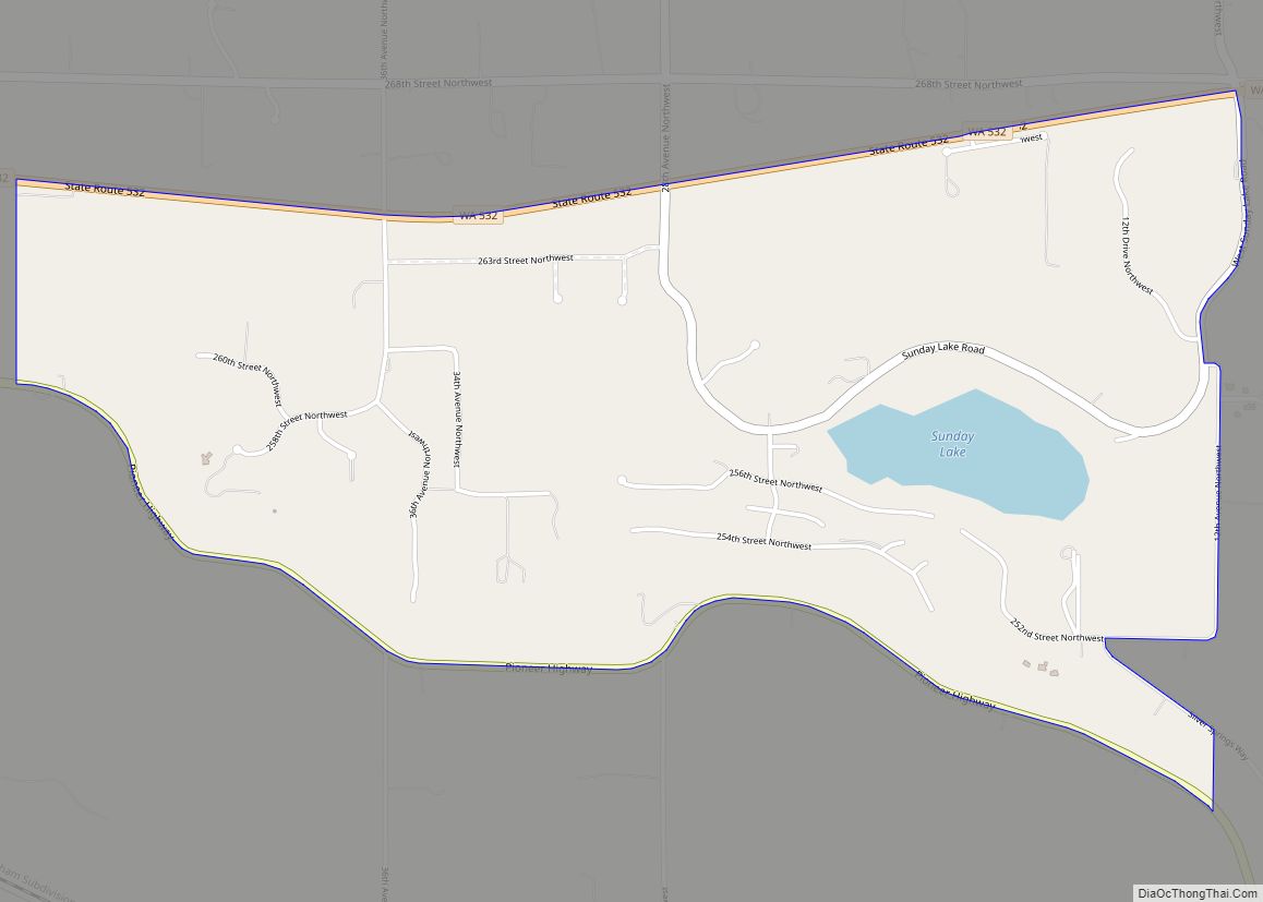
Map of Metaline town

Map of Metaline town

Metaline town overview: Name: Metaline town LSAD Code: 43 LSAD Description: town (suffix) State: Washington County: Pend Oreille County FIPS code: 5345285 Online Interactive Map Metaline online map. Source: Basemap layers from Google Map, Open Street Map (OSM), Arcgisonline, Wmflabs. Boundary Data from Database of Global Administrative Areas. Metaline location map. Where is Metaline town? … Read more

Map of Metaline Falls town

Map of Metaline Falls town

Metaline Falls town overview: Name: Metaline Falls town LSAD Code: 43 LSAD Description: town (suffix) State: Washington County: Pend Oreille County FIPS code: 5345320 Online Interactive Map Metaline Falls online map. Source: Basemap layers from Google Map, Open Street Map (OSM), Arcgisonline, Wmflabs. Boundary Data from Database of Global Administrative Areas. Metaline Falls location map. … Read more

Map of Mesa city, Washington

Map of Mesa city, Washington

Mesa (/ˈmiːsə/) is a city in Franklin County, Washington, United States. The population was 489 at the 2010 census. The Washington State Office of Financial Management’s 2018 estimate placed the population at 513. Mesa city overview: Name: Mesa city LSAD Code: 25 LSAD Description: city (suffix) State: Washington County: Franklin County Elevation: 689 ft (210 m) Total … Read more

Map of Mercer Island city

Map of Mercer Island city

Mercer Island is a city in King County, Washington, United States, located on an island of the same name in the southern portion of Lake Washington. Mercer Island is in the Seattle metropolitan area, with Seattle to its west and Bellevue to its east. Mercer Island is connected to the mainland on both sides by … Read more

Map of Medina city, Washington

Map of Medina city, Washington

Medina (/məˈdaɪnə/ (listen)) is a city in the Eastside region of King County, Washington, United States. The mostly residential city is on a peninsula in Lake Washington, on the opposite shore from Seattle, bordered by Clyde Hill and Hunts Point to the east and water on all other sides. The city’s population was 2,969 at … Read more

Map of Monroe North CDP

Map of Monroe North CDP

Monroe North is a census-designated place (CDP) in Snohomish County, Washington, United States. The population was 1,666 at the 2010 census. Monroe North CDP overview: Name: Monroe North CDP LSAD Code: 57 LSAD Description: CDP (suffix) State: Washington County: Snohomish County Elevation: 246 ft (75 m) Total Area: 2.44 sq mi (6.3 km²) Land Area: 2.44 sq mi (6.3 km²) Water Area: 0.00 sq mi … Read more

Map of Moclips CDP

Map of Moclips CDP

Moclips is an unincorporated community and census-designated place (CDP) in Grays Harbor County, Washington, United States. The population was 207 at the 2010 census. It is located near the mouth of the Moclips River. According to Edmond S. Meany, the word moclips comes from a Quinault word meaning a place where girls were sent as … Read more

Map of Mirrormont CDP

Map of Mirrormont CDP

Mirrormont is a census-designated place (CDP) in King County, Washington, United States, south of Issaquah. The population was 3,858 at the 2020 census. Within the last decade, the area has seen a shift in development as larger homes have been constructed in Cedar Grove, the Highlands at Tiger Mountain and Mirrormont. Mirrormont CDP overview: Name: … Read more

Map of Minnehaha CDP

Map of Minnehaha CDP

Minnehaha is a census-designated place (CDP) in Clark County, Washington, United States. The population was 9,771 at the 2010 census, up from 7,689 at the 2000 census. Minnehaha CDP overview: Name: Minnehaha CDP LSAD Code: 57 LSAD Description: CDP (suffix) State: Washington County: Clark County Elevation: 259 ft (79 m) Total Area: 2.23 sq mi (5.77 km²) Land Area: 2.22 sq mi … Read more

Map of Mineral CDP, Washington

Map of Mineral CDP, Washington

Mineral is an unincorporated community and census-designated place (CDP) in Lewis County, Washington, on State Route 7 near the Pierce/Lewis county line. Mineral originally began as a logging camp and mining town. Prospectors searching the area for gold instead found coal and arsenic. By the early 1920s, the mines closed, and with a devastating fire … Read more

Map of Milton city, Washington

Map of Milton city, Washington

Milton is a city in King and Pierce counties in the U.S. state of Washington. The population was 8,697 at the time of the 2020 census. Milton borders the larger but newer town of Edgewood. Milton city overview: Name: Milton city LSAD Code: 25 LSAD Description: city (suffix) State: Washington County: King County, Pierce County … Read more

Map of Millwood city, Washington

Map of Millwood city, Washington

Millwood is a city in Spokane County, Washington, United States. The population was 1,786 at the 2010 census. Millwood is a suburb of Spokane, and is surrounded on three sides by the city of Spokane Valley. The Spokane River flows along the northern edge of the city. Millwood city overview: Name: Millwood city LSAD Code: … Read more