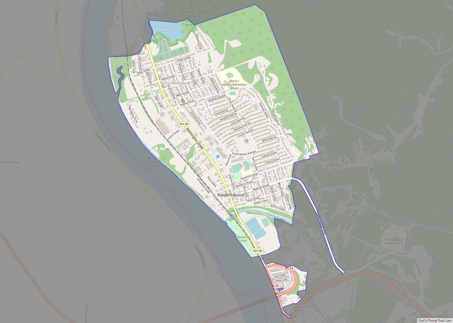
Map of Rand CDP
Rand is a census-designated place (CDP) on the Kanawha River in Kanawha County, West Virginia, United States. As of the 2010 census, its population was 1,631. It is surrounded by the communities of Malden and DuPont City. Rand CDP overview: Name: Rand CDP LSAD Code: 57 LSAD Description: CDP (suffix) State: West Virginia County: Kanawha ... Read more
Map of Rand CDP
Map of Racine CDP, West Virginia
Racine is a census-designated place (CDP) in Boone County, West Virginia, United States. As of the 2010 census, its population was 256. The community was named after Racine, Ohio, the native home of first settlers. Racine is home to the Racine Volunteer Fire Department which covers 174 square miles (450 km) in its first response area. ... Read more
Map of Racine CDP, West Virginia
Map of Rachel CDP, West Virginia
Rachel is a census-designated place (CDP) in Marion County, West Virginia, United States. It is located along Buffalo Creek, 2 miles (3.2 km) east-southeast of Mannington. Rachel has a post office with ZIP code 26587. As of the 2010 census, its population was 248. Rachel is located on U.S. 250 between Farmington and Mannington. Rachel CDP ... Read more
Map of Rachel CDP, West Virginia
Map of Ripley city, West Virginia
Ripley is a city in and the county seat of Jackson County, West Virginia, United States. The population was 3,074 at the 2020 census. Ripley city overview: Name: Ripley city LSAD Code: 25 LSAD Description: city (suffix) State: West Virginia County: Jackson County Elevation: 614 ft (187 m) Total Area: 3.29 sq mi (8.51 km²) Land Area: 3.18 sq mi (8.23 km²) Water ... Read more
Map of Ripley city, West Virginia
Map of Pullman town, West Virginia
Pullman is a town in Ritchie County, West Virginia, United States. The population was 134 at the 2020 census. Pullman was platted in 1883, and named after George Pullman, a businessperson in the rail industry. Pullman town overview: Name: Pullman town LSAD Code: 43 LSAD Description: town (suffix) State: West Virginia County: Ritchie County Elevation: ... Read more
Map of Pullman town, West Virginia
Map of Ridgeley town
Ridgeley is a town in Mineral County, West Virginia, United States, and part of the Cumberland Metropolitan Statistical Area. The population was 590 at the 2020 census. Ridgeley was initially known as St. Clairsville, named for Sir John St Clair, Lt Colonel and Quartermaster General for the British General Edward Braddock. St Clair accompanied Braddock ... Read more
Map of Ridgeley town
Map of Prosperity CDP, West Virginia
Prosperity is a census-designated place (CDP) in Raleigh County, West Virginia, United States. The population was 1,498 at the 2010 census. Prosperity CDP overview: Name: Prosperity CDP LSAD Code: 57 LSAD Description: CDP (suffix) State: West Virginia County: Raleigh County Elevation: 2,467 ft (752 m) Total Area: 2.5 sq mi (6.4 km²) Land Area: 2.5 sq mi (6.4 km²) Water Area: 0.0 sq mi (0.0 km²) ... Read more
Map of Prosperity CDP, West Virginia
Map of Richwood city, West Virginia
Richwood is a city in Nicholas County, West Virginia, United States. In 2020, the census showed Richwood with a population of 1,661. During the 19th and early 20th century Richwood was a booming coal and lumber town. Richwood has a very rich history, including the formation of the Cherry River Navy civic organization to draw ... Read more
Map of Richwood city, West Virginia
Map of Princeton city, West Virginia
Princeton, is a city in and the county seat of Mercer County, West Virginia, United States. The population was 5,872 at the 2020 census. It is part of the Bluefield micropolitan area. The city hosts the Princeton WhistlePigs baseball club of the Appalachian League. Princeton city overview: Name: Princeton city LSAD Code: 25 LSAD Description: ... Read more
Map of Princeton city, West Virginia
Map of Rhodell town
Rhodell is an unincorporated community in Raleigh County, West Virginia, United States. The population was 173 at the 2010 census. Rhodell town overview: Name: Rhodell town LSAD Code: 43 LSAD Description: town (suffix) State: West Virginia County: Raleigh County Elevation: 1,627 ft (496 m) Total Area: 0.31 sq mi (0.81 km²) Land Area: 0.31 sq mi (0.81 km²) Water Area: 0.00 sq mi (0.00 km²) Total ... Read more
Map of Rhodell town
Map of Prince CDP
Prince is a census-designated place (CDP) in Fayette County, West Virginia, United States. As of the 2010 census, its population was 116. Located at an altitude of 1,263 feet (385 m), it is served by an Amtrak station. The community was named after William Prince, an early settler. Prince CDP overview: Name: Prince CDP LSAD Code: 57 ... Read more
Map of Prince CDP
Map of Reedy town
Reedy is a town in Roane County, West Virginia, United States. The population was 152 at the 2020 census. The community was named after nearby Reedy Creek. Reedy town overview: Name: Reedy town LSAD Code: 43 LSAD Description: town (suffix) State: West Virginia County: Roane County Elevation: 679 ft (207 m) Total Area: 0.20 sq mi (0.50 km²) Land Area: ... Read more
Map of Reedy town