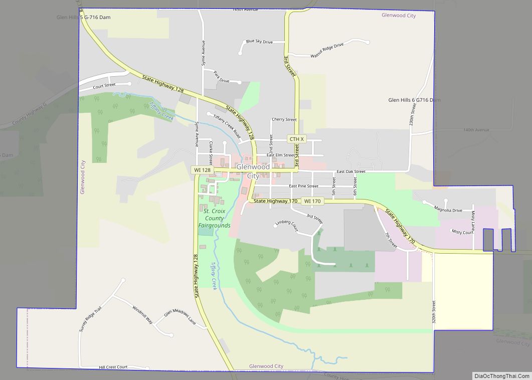
Map of Grafton village, Wisconsin
The Town of Grafton is a town located in Ozaukee County, Wisconsin, United States, and is in the Milwaukee metropolitan area. The town was created in 1846 and at the time of the 2020 Census had a population of 4,157. Grafton is located on the western shore of Lake Michigan. German and Irish immigrants first ... Read more
Map of Grafton village, Wisconsin
Map of Gotham CDP
Gotham (also Richland City) is a census-designated place, in the town of Buena Vista, in Richland County, Wisconsin, United States. It is located at the intersection of Wisconsin Highway 60 and U.S. Route 14. It is just north of the Wisconsin River, northeast of Avoca and southeast of Richland Center. As of the 2020 census, ... Read more
Map of Gotham CDP
Map of Gordon CDP, Wisconsin
Gordon is an unincorporated, census-designated place; located in the town of Gordon, Douglas County, Wisconsin, United States. Gordon CDP overview: Name: Gordon CDP LSAD Code: 57 LSAD Description: CDP (suffix) State: Wisconsin County: Douglas County Elevation: 1,033 ft (315 m) Total Area: 1.856 sq mi (4.81 km²) Land Area: 1.835 sq mi (4.75 km²) Water Area: 0.021 sq mi (0.05 km²) Total Population: 176 Population Density: ... Read more
Map of Gordon CDP, Wisconsin
Map of Goodman CDP, Wisconsin
Goodman is an unincorporated census-designated place located in the town of Goodman, Marinette County, Wisconsin, United States. Goodman is located on U.S. Route 8 19.5 miles (31.4 km) west-southwest of Niagara. Goodman has a post office with ZIP code 54125. As of the 2010 census, its population is 271. Goodman CDP overview: Name: Goodman CDP LSAD ... Read more
Map of Goodman CDP, Wisconsin
Map of Glidden CDP, Wisconsin
Glidden (also Chippewa Crossing) is an unincorporated census-designated place in the town of Jacobs in Ashland County, Wisconsin, United States. It is located on County Highway N near Wisconsin Highway 13. As of the 2010 census, its population was 507. Glidden CDP overview: Name: Glidden CDP LSAD Code: 57 LSAD Description: CDP (suffix) State: Wisconsin ... Read more
Map of Glidden CDP, Wisconsin
Map of Hazel Green village, Wisconsin
Hazel Green is a village in Grant and Lafayette counties in the U.S. state of Wisconsin. The population was 1,256 at the 2010 census. Of this, 1,243 were in Grant County, and only 13 were in Lafayette County. The village is located mostly within the Town of Hazel Green in Grant County; only a small ... Read more
Map of Hazel Green village, Wisconsin
Map of Hayward city, Wisconsin
Hayward is a city in Sawyer County, Wisconsin, United States, next to the Namekagon River. The population was 2,318 at the 2010 census. It is the county seat of Sawyer County. The city is surrounded by the Town of Hayward. Hayward city overview: Name: Hayward city LSAD Code: 25 LSAD Description: city (suffix) State: Wisconsin ... Read more
Map of Hayward city, Wisconsin
Map of Hawkins village, Wisconsin
Hawkins is a town in Rusk County, Wisconsin, United States. The population was 170 at the 2000 census. The Village of Hawkins is located within the town. Hawkins village overview: Name: Hawkins village LSAD Code: 47 LSAD Description: village (suffix) State: Wisconsin County: Rusk County FIPS code: 5533275 Online Interactive Map Hawkins online map. Source: ... Read more
Map of Hawkins village, Wisconsin
Map of Hatley village, Wisconsin
Hatley is a village in Marathon County, Wisconsin, United States. It is part of the Wausau, Wisconsin Metropolitan Statistical Area. The population was 574 at the 2010 census. Hatley village overview: Name: Hatley village LSAD Code: 47 LSAD Description: village (suffix) State: Wisconsin County: Marathon County Elevation: 1,270 ft (387 m) Total Area: 0.98 sq mi (2.53 km²) Land Area: ... Read more
Map of Hatley village, Wisconsin
Map of Hatfield CDP, Wisconsin
Hatfield is an unincorporated census-designated place, in the town of Komensky, Jackson County, Wisconsin, United States. As of the 2010 census, its population is 141. Hatfield CDP overview: Name: Hatfield CDP LSAD Code: 57 LSAD Description: CDP (suffix) State: Wisconsin County: Jackson County Elevation: 889 ft (271 m) Total Area: 1.337 sq mi (3.46 km²) Land Area: 1.337 sq mi (3.46 km²) Water ... Read more
Map of Hatfield CDP, Wisconsin
Map of Harrison village, Wisconsin
Harrison is a village in Calumet and Outagamie Counties, Wisconsin, United States. The village was created on March 8, 2013, from unincorporated areas of the Town of Harrison and a portion of the Town of Buchanan: the right of way along County Trunk Highway KK in Outagamie County. The village is located in what was ... Read more
Map of Harrison village, Wisconsin
Map of Hanover CDP, Wisconsin
Hanover is an unincorporated census-designated place located in the town of Plymouth, Rock County, Wisconsin, United States. It is west of Janesville and east of Orfordville. As of the 2020 census, its population was 179. Hanover CDP overview: Name: Hanover CDP LSAD Code: 57 LSAD Description: CDP (suffix) State: Wisconsin County: Rock County Elevation: 794 ft ... Read more
Map of Hanover CDP, Wisconsin