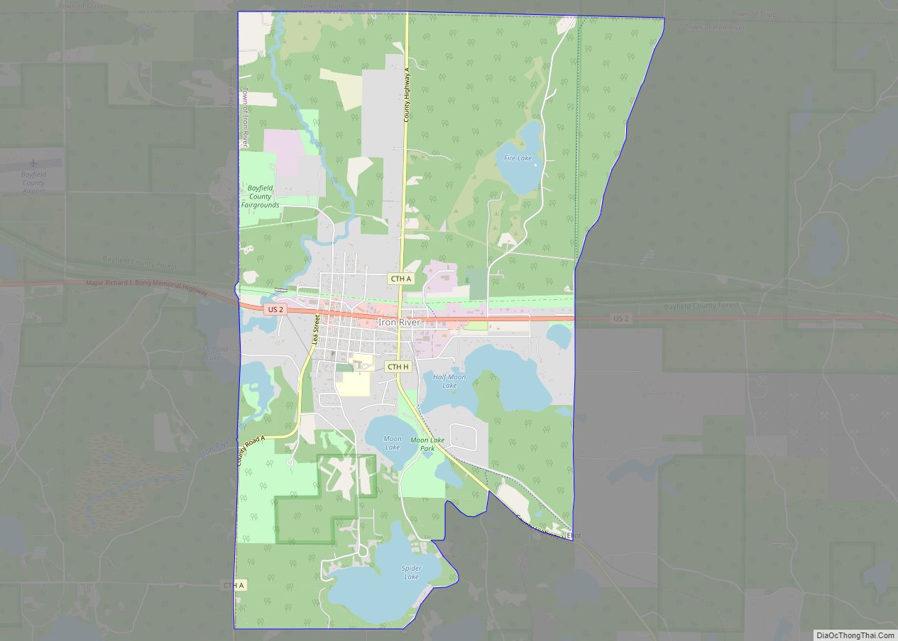
Map of Cornell city, Wisconsin

Map of Cornell city, Wisconsin

Cornell is a city in Chippewa County, Wisconsin, United States. The population was 1,467 at the 2010 census. It is located on the Chippewa River, upstream from Lake Wissota and Chippewa Falls, where Highway 64 crosses the river and Highway 27. Cornell city overview: Name: Cornell city LSAD Code: 25 LSAD Description: city (suffix) State: … Read more

Map of Coon Valley village

Map of Coon Valley village

Coon Valley is a village in Vernon County, Wisconsin, United States. The population was 758 at the 2020 census. Coon Valley was hit by the floods ravaging Wisconsin in 2018. Coon Valley village overview: Name: Coon Valley village LSAD Code: 47 LSAD Description: village (suffix) State: Wisconsin County: Vernon County Elevation: 738 ft (225 m) Total Area: … Read more

Map of Conrath village

Map of Conrath village

Conrath is a village in Rusk County, Wisconsin, United States. The population was 95 at the 2010 census. Conrath village overview: Name: Conrath village LSAD Code: 47 LSAD Description: village (suffix) State: Wisconsin County: Rusk County Elevation: 1,135 ft (346 m) Total Area: 0.52 sq mi (1.35 km²) Land Area: 0.52 sq mi (1.35 km²) Water Area: 0.00 sq mi (0.00 km²) Total Population: 95 Population … Read more

Map of Como CDP, Wisconsin

Map of Como CDP, Wisconsin

Como is a census-designated place (CDP) in the town of Geneva, Walworth County, Wisconsin, United States. The population was 2,356 at the 2020 census. Como CDP overview: Name: Como CDP LSAD Code: 57 LSAD Description: CDP (suffix) State: Wisconsin County: Walworth County Elevation: 915 ft (279 m) Total Area: 3.5 sq mi (9.1 km²) Land Area: 3.0 sq mi (7.8 km²) Water Area: … Read more

Map of Combined Locks village

Map of Combined Locks village

Combined Locks is a village in Outagamie County, Wisconsin, United States. The population was 3,328 at the 2010 census. Combined Locks village overview: Name: Combined Locks village LSAD Code: 47 LSAD Description: village (suffix) State: Wisconsin County: Outagamie County Elevation: 725 ft (221 m) Total Area: 1.91 sq mi (4.93 km²) Land Area: 1.72 sq mi (4.44 km²) Water Area: 0.19 sq mi (0.49 km²) Total … Read more

Map of Columbus city, Wisconsin

Map of Columbus city, Wisconsin

Columbus is a city in Columbia (mostly) and Dodge Counties in the south-central part of the U.S. state of Wisconsin. The population was 5,540 at the 2020 census. All of this population resided in the Columbia County portion of the city. Columbus is located about 28 miles (45 km) northeast of Madison on the Crawfish River. … Read more

Map of Coloma village, Wisconsin

Map of Coloma village, Wisconsin

Coloma is a town in Waushara County, Wisconsin, United States. The population was 748 at the 2000 census. The coordinates shown are for the Village of Coloma, located within the town. Coloma village overview: Name: Coloma village LSAD Code: 47 LSAD Description: village (suffix) State: Wisconsin County: Waushara County Elevation: 260 m (850 ft) FIPS code: 5516375 … Read more

Map of Cumberland city, Wisconsin

Map of Cumberland city, Wisconsin

Cumberland is a city in Barron County in the U.S. state of Wisconsin. The population was 2,170 at the 2010 census. The city is located partially within the Town of Cumberland. It was incorporated in 1885. Cumberland city overview: Name: Cumberland city LSAD Code: 25 LSAD Description: city (suffix) State: Wisconsin County: Barron County Elevation: … Read more

Map of Collins CDP, Wisconsin

Map of Collins CDP, Wisconsin

Collins is an unincorporated census-designated place in the town of Rockland, Manitowoc County, Wisconsin, United States, in the east central part of the state. Its zip code is 54207, although its post office is being studied for closure. As of the 2010 census, its population is 164. The Collins Marsh Wildlife Area is located east … Read more

Map of Cudahy city, Wisconsin

Map of Cudahy city, Wisconsin

Cudahy (/ˈkʌdəheɪ/) is a city in Milwaukee County, Wisconsin, United States. The population was 18,204 at the 2020 census. Cudahy city overview: Name: Cudahy city LSAD Code: 25 LSAD Description: city (suffix) State: Wisconsin County: Milwaukee County Elevation: 722 ft (220 m) Total Area: 4.77 sq mi (12.36 km²) Land Area: 4.77 sq mi (12.36 km²) Water Area: 0.00 sq mi (0.00 km²) Total Population: 18,204 … Read more

Map of Colfax village, Wisconsin

Map of Colfax village, Wisconsin

Colfax is a town in Dunn County, Wisconsin, United States. The population was 909 at the 2000 census. Colfax village overview: Name: Colfax village LSAD Code: 47 LSAD Description: village (suffix) State: Wisconsin County: Dunn County FIPS code: 5516275 Online Interactive Map Colfax online map. Source: Basemap layers from Google Map, Open Street Map (OSM), … Read more

Map of Cuba City city

Map of Cuba City

Cuba City is a city partly in Grant County and partly in Lafayette County in the U.S. state of Wisconsin. The population was 2,086 at the 2010 census. Of this, 1,877 were in Grant County, and 209 were in Lafayette County. The city is nicknamed “The City of Presidents” because of the presidential banners displayed … Read more