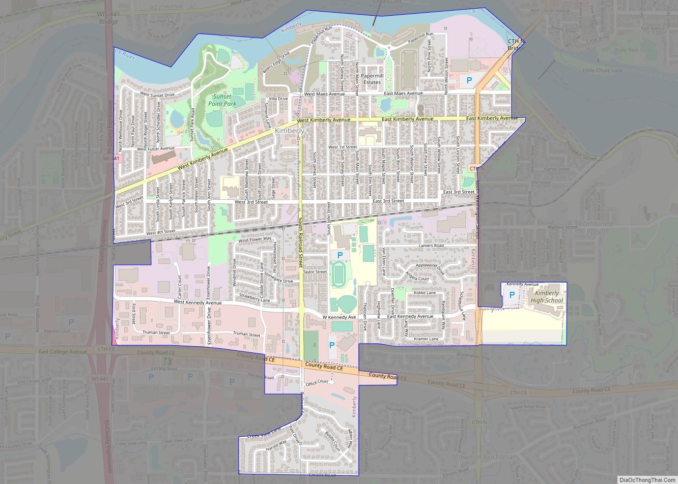
Map of Kohler village
Kohler is a village in Sheboygan County, Wisconsin, United States, along the Sheboygan River. The population was 2,120 at the 2010 census. It is included in the Sheboygan, Wisconsin Metropolitan Statistical Area. Kohler village overview: Name: Kohler village LSAD Code: 47 LSAD Description: village (suffix) State: Wisconsin County: Sheboygan County Elevation: 686 ft (209 m) Total Area: ... Read more
Map of Kohler village
Map of Knowlton CDP
Knowlton is a census-designated place in the town of Knowlton, Marathon County, Wisconsin, United States. Its population was 120 as of the 2010 census. The northern terminus for Wisconsin Highway 34 is located just north of Knowlton and the highway passes through the community. Knowlton CDP overview: Name: Knowlton CDP LSAD Code: 57 LSAD Description: ... Read more
Map of Knowlton CDP
Map of Lake Koshkonong CDP
Lake Koshkonong is a census-designated place (CDP) in the towns of Koshkonong and Sumner, Jefferson County, Wisconsin, United States. The population was 1,239 at the 2020 census. Lake Koshkonong is in the area. Lake Koshkonong CDP overview: Name: Lake Koshkonong CDP LSAD Code: 57 LSAD Description: CDP (suffix) State: Wisconsin County: Jefferson County Elevation: 781 ft ... Read more
Map of Lake Koshkonong CDP
Map of Lake Ivanhoe CDP
Lake Ivanhoe is a census-designated place in the Town of Bloomfield, Walworth County, Wisconsin, United States. It was developed in the 1920s as a resort community for middle-class Black Chicagoans. Its population was 461 as of the 2020 census. Lake Ivanhoe CDP overview: Name: Lake Ivanhoe CDP LSAD Code: 57 LSAD Description: CDP (suffix) State: ... Read more
Map of Lake Ivanhoe CDP
Map of Lake Hallie village
Lake Hallie is a village in Chippewa County, Wisconsin, United States. It was incorporated from part of the Town of Hallie on February 18, 2003. The 2010 census put the village’s population at 6,448. Lake Hallie village overview: Name: Lake Hallie village LSAD Code: 47 LSAD Description: village (suffix) State: Wisconsin County: Chippewa County Elevation: ... Read more
Map of Lake Hallie village
Map of Lake Geneva city
Lake Geneva is a city in the U.S. state of Wisconsin. Located in Walworth County and situated on Geneva Lake, it was home to 8,277 people as of the 2020 census, up from 7,651 at the 2010 census. It is about 40 miles southwest of Milwaukee and 65 miles northwest of Chicago. Given its relative ... Read more
Map of Lake Geneva city
Map of Lannon village
Lannon is a village in Waukesha County, Wisconsin, United States. The population was 1,355 at the 2020 census. Lannon is a part of the Milwaukee metropolitan area. Lannon village overview: Name: Lannon village LSAD Code: 47 LSAD Description: village (suffix) State: Wisconsin County: Waukesha County Elevation: 915 ft (279 m) Total Area: 2.49 sq mi (6.45 km²) Land Area: 2.47 sq mi ... Read more
Map of Lannon village
Map of Lancaster city, Wisconsin
Lancaster is a city in and the county seat of Grant County, Wisconsin, United States. The population was 3,907 at the 2020 census. Lancaster city overview: Name: Lancaster city LSAD Code: 25 LSAD Description: city (suffix) State: Wisconsin County: Grant County Elevation: 1,099 ft (335 m) Total Area: 3.01 sq mi (7.80 km²) Land Area: 3.01 sq mi (7.80 km²) Water Area: 0.00 sq mi ... Read more
Map of Lancaster city, Wisconsin
Map of Lake Camelot CDP, Wisconsin
Lake Camelot is a census-designated place in the town of Rome, Adams County, Wisconsin, United States. Its population was 826 as of the 2010 census. Lake Camelot CDP overview: Name: Lake Camelot CDP LSAD Code: 57 LSAD Description: CDP (suffix) State: Wisconsin County: Adams County Elevation: 1,020 ft (310 m) Total Area: 4.391 sq mi (11.37 km²) Land Area: 3.774 sq mi ... Read more
Map of Lake Camelot CDP, Wisconsin
Map of Lake Arrowhead CDP, Wisconsin
Lake Arrowhead is a census-designated place in the town of Rome, Adams County, Wisconsin, United States. Its population was 838 as of the 2010 census. Lake Arrowhead CDP overview: Name: Lake Arrowhead CDP LSAD Code: 57 LSAD Description: CDP (suffix) State: Wisconsin County: Adams County Elevation: 988 ft (301 m) Total Area: 5.502 sq mi (14.25 km²) Land Area: 5.032 sq mi ... Read more
Map of Lake Arrowhead CDP, Wisconsin
Map of Lake Wissota CDP
Lake Wissota is a census-designated place (CDP) in the town of Lafayette in Chippewa County in the U.S. state of Wisconsin. The population was 2,738 at the 2010 census. The CDP, known locally as Lake Wissota Village, is located along the southern shores of Lake Wissota. Lake Wissota CDP overview: Name: Lake Wissota CDP LSAD ... Read more
Map of Lake Wissota CDP
Map of Lake Wisconsin CDP
Lake Wisconsin is a census-designated place (CDP) in Columbia and Sauk counties, in the towns of Lodi and Merrimac, in Wisconsin, United States. The population was 4,189 at the 2010 census. The Columbia County portion of the Lake Wisconsin is part of the Madison Metropolitan Statistical Area, while the Sauk County portion is part of ... Read more
Map of Lake Wisconsin CDP