Map of Lowell village, Wisconsin
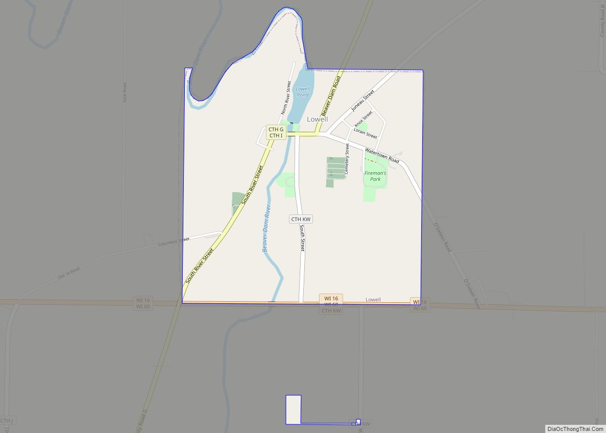
Lowell is a town in Dodge County, Wisconsin, United States. The population was 1,169 at the 2000 census. The Village of Lowell and the unincorporated community of North Lowell are located in the town. Lowell village overview: Name: Lowell village LSAD Code: 47 LSAD Description: village (suffix) State: Wisconsin County: Dodge County FIPS code: 5545950 ... Read more
Map of Lowell village, Wisconsin
Map of Maribel village
Maribel is a village in Manitowoc County, Wisconsin, United States. The population was 351 at the 2010 census. Maribel village overview: Name: Maribel village LSAD Code: 47 LSAD Description: village (suffix) State: Wisconsin County: Manitowoc County Elevation: 860 ft (262 m) Total Area: 1.15 sq mi (2.97 km²) Land Area: 1.14 sq mi (2.96 km²) Water Area: 0.00 sq mi (0.01 km²) Total Population: 351 Population ... Read more
Map of Maribel village
Map of Marengo CDP, Wisconsin
Marengo is an unincorporated census-designated place located in the town of White River, Ashland County, Wisconsin, United States. Marengo is located on Wisconsin Highway 13 10 miles (16 km) northwest of Mellen. Marengo had a post office, which closed on June 27, 2009. At the 2010 census, its population was 111. Bus service to the community ... Read more
Map of Marengo CDP, Wisconsin
Map of Marathon City village
Marathon City is a village in Marathon County, Wisconsin, United States. It is part of the Wausau, Wisconsin Metropolitan Statistical Area. The population was 1,524 at the 2010 census. The village was incorporated from a part of the original area of the town of Marathon. The village dates back to 1856. The name of the ... Read more
Map of Marathon City village
Map of Medford city, Wisconsin
Medford is a city in Taylor County, in north-central Wisconsin, United States. The population was 4,349 at the 2020 census. The city is located mostly within the boundaries of the Town of Medford. It is the county seat of Taylor County. Medford city overview: Name: Medford city LSAD Code: 25 LSAD Description: city (suffix) State: ... Read more
Map of Medford city, Wisconsin
Map of McFarland village, Wisconsin
McFarland is a village in Dane County, Wisconsin, situated on the shores of Lake Waubesa to the southeast of Madison. As of the 2020 U.S. Census, the village has a population of 8,991. Spanning just under 5 square miles in land area and encompassing roughly 43.50 miles of roads, McFarland is part of the Madison ... Read more
Map of McFarland village, Wisconsin
Map of Mazomanie village
Mazomanie is a town in Dane County, Wisconsin. The population was 1,185 at the time of the 2000 census. The Village of Mazomanie is located within the town. Mazomanie village overview: Name: Mazomanie village LSAD Code: 47 LSAD Description: village (suffix) State: Wisconsin County: Dane County FIPS code: 5550225 Online Interactive Map Mazomanie online map. ... Read more
Map of Mazomanie village
Map of Mayville city, Wisconsin
Mayville is a city in Dodge County, Wisconsin, United States, located along the Rock River and the Horicon Marsh. The population was 5,154 at the 2010 census. Mayville city overview: Name: Mayville city LSAD Code: 25 LSAD Description: city (suffix) State: Wisconsin County: Dodge County Elevation: 929 ft (283 m) Total Area: 3.37 sq mi (8.72 km²) Land Area: 3.25 sq mi ... Read more
Map of Mayville city, Wisconsin
Map of Merton village
Merton is a town in Waukesha County, Wisconsin, United States; before Wisconsin statehood, it was called Warren. The population was 8,277 at the 2020 census. The town surrounds the villages of Chenequa and Merton. The unincorporated communities of Camp Whitcomb, Monches, and North Lake are in the town and the unincorporated community of Stone Bank ... Read more
Map of Merton village
Map of Mauston city
Mauston is a city in and the county seat of Juneau County, Wisconsin, United States. The population was 4,347 as of the 2020 census. It is approximately 70 miles northwest from the state capital, Madison. Mauston city overview: Name: Mauston city LSAD Code: 25 LSAD Description: city (suffix) State: Wisconsin County: Juneau County Elevation: 883 ft ... Read more
Map of Mauston city
Map of Merrimac village, Wisconsin
Merrimac is a town in Sauk County, Wisconsin, United States. The population was 868 at the 2000 census. The Village of Merrimac is located within the town. The unincorporated community of Moon Valley is located in the town. The census-designated place of Lake Wisconsin is also located partially in the town. Merrimac village overview: Name: ... Read more
Map of Merrimac village, Wisconsin
Map of Mattoon village, Wisconsin
Mattoon is a village in Shawano County, Wisconsin, United States. The population was 438 at the 2010 census. Mattoon village overview: Name: Mattoon village LSAD Code: 47 LSAD Description: village (suffix) State: Wisconsin County: Shawano County Elevation: 1,276 ft (389 m) Total Area: 1.64 sq mi (4.25 km²) Land Area: 1.64 sq mi (4.25 km²) Water Area: 0.00 sq mi (0.00 km²) Total Population: 438 Population ... Read more
Map of Mattoon village, Wisconsin