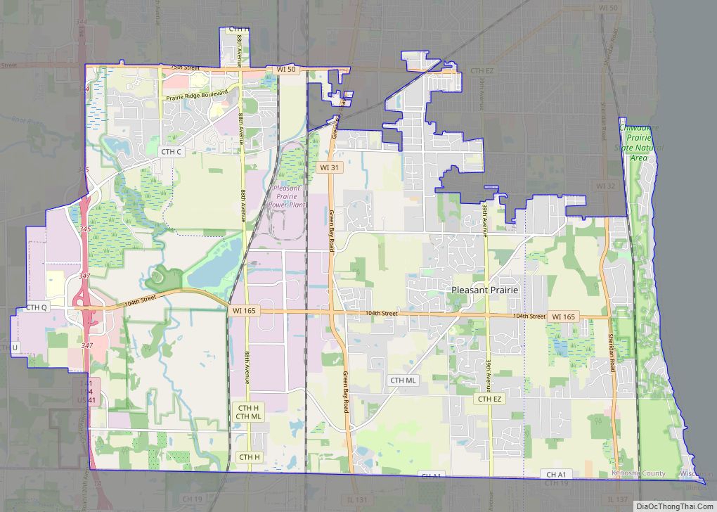
Map of Pound village, Wisconsin
Pound is a town in Marinette County, Wisconsin, United States. The population was 1,367 at the 2000 census. The village of Pound is located within but politically independent of the town. Pound village overview: Name: Pound village LSAD Code: 47 LSAD Description: village (suffix) State: Wisconsin County: Marinette County FIPS code: 5564750 Online Interactive Map ... Read more
Map of Pound village, Wisconsin
Map of Plainfield village, Wisconsin
Plainfield is a town in Waushara County, Wisconsin, United States. The population was 533 at the 2000 census. The village of Plainfield is surrounded by the town. The ghost town of West Plainfield (still the present day site of the Town of Plainfield town hall) is located in the town. Plainfield village overview: Name: Plainfield ... Read more
Map of Plainfield village, Wisconsin
Map of Readstown village
Readstown is a village in Vernon County, Wisconsin, United States. The population was 415 at the 2010 census. Readstown village overview: Name: Readstown village LSAD Code: 47 LSAD Description: village (suffix) State: Wisconsin County: Vernon County Elevation: 761 ft (232 m) Total Area: 1.73 sq mi (4.49 km²) Land Area: 1.71 sq mi (4.43 km²) Water Area: 0.02 sq mi (0.05 km²) Total Population: 415 Population ... Read more
Map of Readstown village
Map of Random Lake village
Random Lake is a village in Sheboygan County, Wisconsin, United States. The population was 1,594 at the 2010 census. It is part of the Sheboygan, Wisconsin Metropolitan Statistical Area. Random Lake village overview: Name: Random Lake village LSAD Code: 47 LSAD Description: village (suffix) State: Wisconsin County: Sheboygan County Elevation: 889 ft (271 m) Total Area: 1.76 sq mi ... Read more
Map of Random Lake village
Map of Randolph village, Wisconsin
Randolph is a village in Columbia and Dodge Counties in the U.S. state of Wisconsin. The population was 1,811 at the 2010 census. Of this, 1,339 were in Dodge County, and 472 were in Columbia County. The village is located at the southeast corner of the Town of Randolph in Columbia County, although only a ... Read more
Map of Randolph village, Wisconsin
Map of Radisson village
Radisson is a town in Sawyer County, Wisconsin, United States. The population was 465 at the 2000 census. The Village of Radisson is located within the town. Radisson village overview: Name: Radisson village LSAD Code: 47 LSAD Description: village (suffix) State: Wisconsin County: Sawyer County FIPS code: 5566050 Online Interactive Map Radisson online map. Source: ... Read more
Map of Radisson village
Map of Pulcifer CDP
Pulcifer is an unincorporated census-designated place in the town of Green Valley, Shawano County, Wisconsin, United States. Pulcifer is located on the Oconto River and Wisconsin Highway 22 5 miles (8.0 km) northeast of Cecil. As of the 2010 census, its population is 134. Pulcifer CDP overview: Name: Pulcifer CDP LSAD Code: 57 LSAD Description: CDP ... Read more
Map of Pulcifer CDP
Map of Princeton city, Wisconsin
Princeton is a city in western part of Green Lake County, Wisconsin, United States. The population was 1,214 at the 2010 census. The city is located within the Town of Princeton. The Fox River flows through the city, dividing the city into an east half and west half. Princeton city overview: Name: Princeton city LSAD ... Read more
Map of Princeton city, Wisconsin
Map of Rib Lake village
Rib Lake is a town in Taylor County, Wisconsin, United States. The population was 768 at the 2000 census. The village of Rib Lake is completely surrounded by the town. Rib Lake village overview: Name: Rib Lake village LSAD Code: 47 LSAD Description: village (suffix) State: Wisconsin County: Taylor County Elevation: 1,581 ft (482 m) Total Area: ... Read more
Map of Rib Lake village
Map of Rhinelander city
Rhinelander is a city in and the county seat of Oneida County, Wisconsin, United States. The population was 8,285 at the 2020 census. Rhinelander city overview: Name: Rhinelander city LSAD Code: 25 LSAD Description: city (suffix) State: Wisconsin County: Oneida County Elevation: 1,549 ft (472 m) Total Area: 8.68 sq mi (22.47 km²) Land Area: 8.42 sq mi (21.82 km²) Water Area: 0.25 sq mi ... Read more
Map of Rhinelander city
Map of Prairie Farm village
Prairie Farm is a town in Barron County in the U.S. state of Wisconsin. The population was 573 at the 2010 census. The village of Prairie Farm is surrounded by the town. Prairie Farm village overview: Name: Prairie Farm village LSAD Code: 47 LSAD Description: village (suffix) State: Wisconsin County: Barron County FIPS code: 5565150 ... Read more
Map of Prairie Farm village
Map of Rewey village
Rewey is a village in Iowa County, Wisconsin, United States. The population was 292 at the 2010 census. It is part of the Madison Metropolitan Statistical Area. Rewey village overview: Name: Rewey village LSAD Code: 47 LSAD Description: village (suffix) State: Wisconsin County: Iowa County Elevation: 1,129 ft (344 m) Total Area: 0.51 sq mi (1.31 km²) Land Area: 0.51 sq mi ... Read more
Map of Rewey village