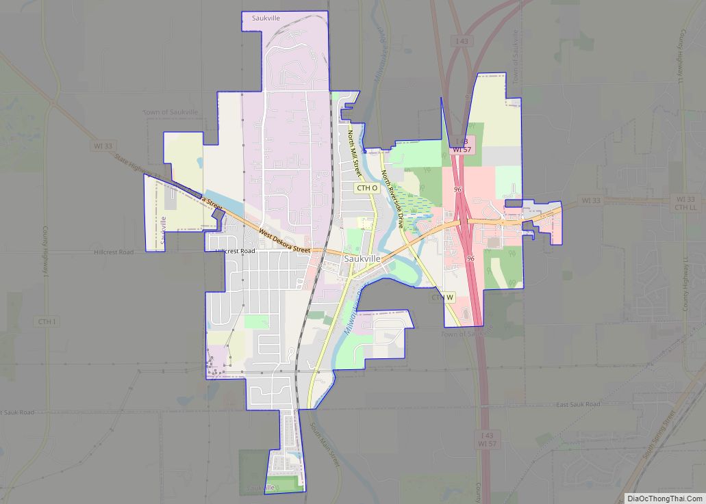
Map of Shawano city
Shawano (pronounced SHAW-no) is a city in Shawano County, Wisconsin, United States. The population was 9,305 at the 2010 census. It is the county seat of Shawano County. Shawano city overview: Name: Shawano city LSAD Code: 25 LSAD Description: city (suffix) State: Wisconsin County: Shawano County Elevation: 817 ft (249 m) Total Area: 6.94 sq mi (17.96 km²) Land Area: ... Read more
Map of Shawano city
Map of Sharon village, Wisconsin
Sharon is a village in Walworth County, Wisconsin, United States. The population was 1,586 at the 2020 census. The village is adjacent to the Town of Sharon. Sharon village overview: Name: Sharon village LSAD Code: 47 LSAD Description: village (suffix) State: Wisconsin County: Walworth County Total Area: 1.73 sq mi (4.47 km²) Land Area: 1.73 sq mi (4.47 km²) Water Area: ... Read more
Map of Sharon village, Wisconsin
Map of Seymour CDP, Wisconsin
Seymour is a census-designated place (CDP) in Eau Claire County, Wisconsin, United States. The population was 1,418 at the 2010 census. It is located within the town of Seymour and is part of the Eau Claire urban area. Seymour CDP overview: Name: Seymour CDP LSAD Code: 57 LSAD Description: CDP (suffix) State: Wisconsin County: Eau ... Read more
Map of Seymour CDP, Wisconsin
Map of Sextonville CDP
Sextonville is an unincorporated census-designated place located in the town of Buena Vista in Richland County, Wisconsin, United States. Sextonville is located on U.S. Route 14 southeast of Richland Center. Sextonville has a post office with ZIP code 53584. As of the 2020 census, its population was 476. Sextonville CDP overview: Name: Sextonville CDP LSAD ... Read more
Map of Sextonville CDP
Map of Schofield city
Schofield is a city in Marathon County, Wisconsin, United States. It is part of the Wausau, Wisconsin Metropolitan Statistical Area. The population was 2,157 at the 2020 census. The city was named for William Scholfield, who came to the area in the 1851 to open a sawmill. The city has since dropped the “L” from ... Read more
Map of Schofield city
Map of Scandinavia village
Scandinavia is a town in Waupaca County, Wisconsin, United States. The population was 1,075 at the 2000 census. The Village of Scandinavia is located within the town. Scandinavia village overview: Name: Scandinavia village LSAD Code: 47 LSAD Description: village (suffix) State: Wisconsin County: Waupaca County Total Area: 34.2 sq mi (88.7 km²) Land Area: 33.8 sq mi (87.5 km²) Water Area: ... Read more
Map of Scandinavia village
Map of Sayner CDP
Sayner is a census-designated place in the Town of Plum Lake in Vilas County, Wisconsin, United States. It is located at the intersection of Highway 155 and County N, about 15 miles northwest of Eagle River. As of the 2010 census, its population was 207. Sayner has an area of 1.828 square miles (4.73 km); 1.826 ... Read more
Map of Sayner CDP
Map of Saxon CDP, Wisconsin
Saxon is an unincorporated census-designated place located in the town of Saxon, Iron County, Wisconsin, United States. Saxon is located on Wisconsin Highway 122 11 miles (18 km) west-northwest of Hurley. Saxon has a post office with ZIP code 54559. As of the 2010 census, its population is 90. Saxon CDP overview: Name: Saxon CDP LSAD ... Read more
Map of Saxon CDP, Wisconsin
Map of Spring Valley village, Wisconsin
Spring Valley is a village in Pierce and St. Croix counties in Wisconsin, United States. The population was 1,401 at the 2020 census. Of those, 1,390 were in Pierce County and 11 in St. Croix County. The village is mostly within the Town of Spring Lake in Pierce County. Small parts also lie in the ... Read more
Map of Spring Valley village, Wisconsin
Map of Spring Green village
The Town of Spring Green is located in Sauk County, Wisconsin, United States. The January 1, 2021 final population estimate for the town is 1,728. Approximately 1,374 of the estimated population for the Town of Spring Green in Sauk County are of voting age. Spring Green village overview: Name: Spring Green village LSAD Code: 47 ... Read more
Map of Spring Green village
Map of Spencer village, Wisconsin
The Town of Spencer is located in Marathon County, Wisconsin, United States. It is part of the Wausau, WI Metropolitan Statistical Area. The population was 1,581 at the 2010 census. The village of Spencer is located in the northeastern part of the town.The unincorporated community of Mann also is located in the town. Spencer village ... Read more
Map of Spencer village, Wisconsin
Map of Sparta city, Wisconsin
Sparta is a city in and the county seat of Monroe County, Wisconsin, United States, along the La Crosse River. The population was 10,025 at the 2020 census. Sparta city overview: Name: Sparta city LSAD Code: 25 LSAD Description: city (suffix) State: Wisconsin County: Monroe County Total Area: 8.06 sq mi (20.88 km²) Land Area: 8.01 sq mi (20.74 km²) Water ... Read more
Map of Sparta city, Wisconsin