Map of St. Francis city, Wisconsin
St. Francis is a city in Milwaukee County, Wisconsin, United States. The population was 9,161 at the 2020 census. St. Francis city overview: Name: St. Francis city LSAD Code: 25 LSAD Description: city (suffix) State: Wisconsin County: Milwaukee County Incorporated: July 25, 1951; 71 years ago (1951-07-25) Elevation: 692 ft (211 m) Total Area: 2.57 sq mi (6.65 km²) Land Area: 2.57 sq mi ... Read more
Map of St. Francis city, Wisconsin
Map of Strum village
Strum is a village in Trempealeau County, Wisconsin, along the Buffalo River. The population was 1,114 at the 2010 census. Strum village overview: Name: Strum village LSAD Code: 47 LSAD Description: village (suffix) State: Wisconsin County: Trempealeau County Elevation: 909 ft (277 m) Total Area: 1.33 sq mi (3.44 km²) Land Area: 1.23 sq mi (3.18 km²) Water Area: 0.10 sq mi (0.26 km²) Total Population: ... Read more
Map of Strum village
Map of Stratford village, Wisconsin
Stratford is a village in Marathon County, Wisconsin, United States. It is part of the Wausau, Wisconsin Metropolitan Statistical Area. The population was 1,578 at the 2010 census. Stratford village overview: Name: Stratford village LSAD Code: 47 LSAD Description: village (suffix) State: Wisconsin County: Marathon County Elevation: 1,266 ft (386 m) Total Area: 5.34 sq mi (13.83 km²) Land Area: ... Read more
Map of Stratford village, Wisconsin
Map of Stoughton city
Stoughton is a city in Dane County, Wisconsin, United States. It straddles the Yahara River about 20 miles southeast of the state capital, Madison. Stoughton is part of the Madison Metropolitan Statistical Area. As of the 2020 census, the population was 13,173. Known for its Norwegian heritage, Stoughton hosts a citywide celebration of Syttende Mai, ... Read more
Map of Stoughton city
Map of Stockbridge village, Wisconsin
Stockbridge is a town in Calumet County, Wisconsin. The population was 1,456 at the time of the 2010 census. The village of Stockbridge, and the unincorporated communities of Kloten, Quinney, and Saint Catherines Bay are located within the town. Stockbridge village overview: Name: Stockbridge village LSAD Code: 47 LSAD Description: village (suffix) State: Wisconsin County: ... Read more
Map of Stockbridge village, Wisconsin
Map of Stevens Point city
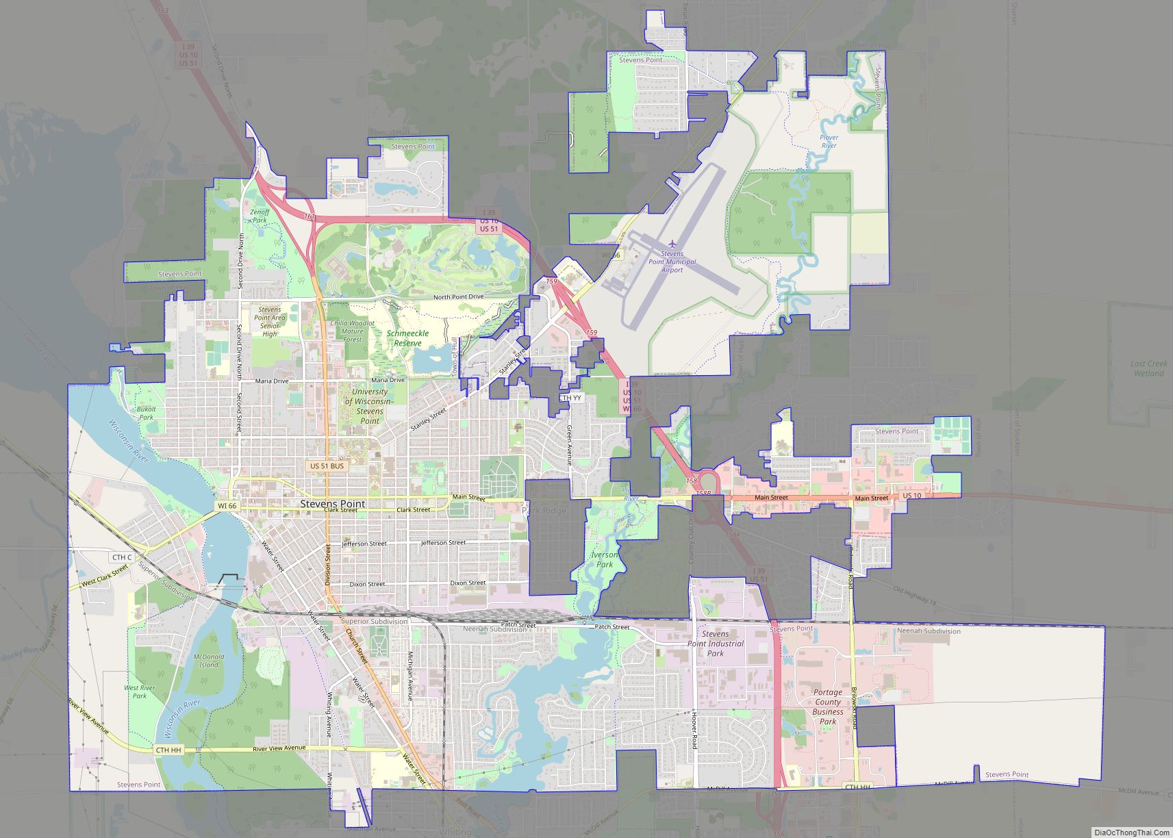
Stevens Point is the county seat of Portage County, Wisconsin, United States. The city was incorporated in 1858. Its 2020 population of 25,666 makes it the largest city in the county. Stevens Point forms the core of the United States Census Bureau’s Stevens Point Micropolitan Statistical Area, which had a 2020 population of 70,377 Stevens ... Read more
Map of Stevens Point city
Map of Steuben village
Steuben is a village in Crawford County, Wisconsin, United States. The population was 131 at the 2010 census. Steuben village overview: Name: Steuben village LSAD Code: 47 LSAD Description: village (suffix) State: Wisconsin County: Crawford County Elevation: 676 ft (206 m) Total Area: 6.19 sq mi (16.04 km²) Land Area: 6.19 sq mi (16.04 km²) Water Area: 0.00 sq mi (0.00 km²) Total Population: 131 Population ... Read more
Map of Steuben village
Map of Stetsonville village
Stetsonville is a village in Taylor County, Wisconsin, United States. The population was 541 at the 2010 census. Stetsonville village overview: Name: Stetsonville village LSAD Code: 47 LSAD Description: village (suffix) State: Wisconsin County: Taylor County Elevation: 1,453 ft (443 m) Total Area: 0.39 sq mi (1.01 km²) Land Area: 0.39 sq mi (1.01 km²) Water Area: 0.00 sq mi (0.00 km²) Total Population: 541 Population ... Read more
Map of Stetsonville village
Map of Star Prairie village
Star Prairie is a town in St. Croix County, Wisconsin, United States. The population was 2,944 at the 2000 census. The Village of Star Prairie is located on the eastern boundary of the town. The unincorporated communities of Huntington and Johannesburg are located in the town. Star Prairie village overview: Name: Star Prairie village LSAD ... Read more
Map of Star Prairie village
Map of Stanley city, Wisconsin
Stanley is a city in Chippewa and Clark counties in the U.S. state of Wisconsin. The population was 3,608 at the 2010 census. Of this, 3,602 were in Chippewa County, and 6 in Clark County. Stanley city overview: Name: Stanley city LSAD Code: 25 LSAD Description: city (suffix) State: Wisconsin County: Chippewa County, Clark County ... Read more
Map of Stanley city, Wisconsin
Map of Sullivan village, Wisconsin
Sullivan is a town in Jefferson County, Wisconsin, United States. The population was 2,208 at the 2010 census. The village of Sullivan, the census-designated place of Rome, and the unincorporated communities of Heath Mills, Oak Hill, and Slabtown are located in the town. Sullivan village overview: Name: Sullivan village LSAD Code: 47 LSAD Description: village ... Read more
Map of Sullivan village, Wisconsin
Map of St. Peter CDP, Wisconsin
St. Peter, Wisconsin is an unincorporated census-designated place in the Town of Taycheedah in Fond du Lac County, Wisconsin. It is located approximately 2 miles (3.2 km) northeast of Peebles and 1 mile (1.6 km) south of Silica. It was located on Wisconsin Highway 149 before the highway was decommissioned and turned over to county control as ... Read more
Map of St. Peter CDP, Wisconsin