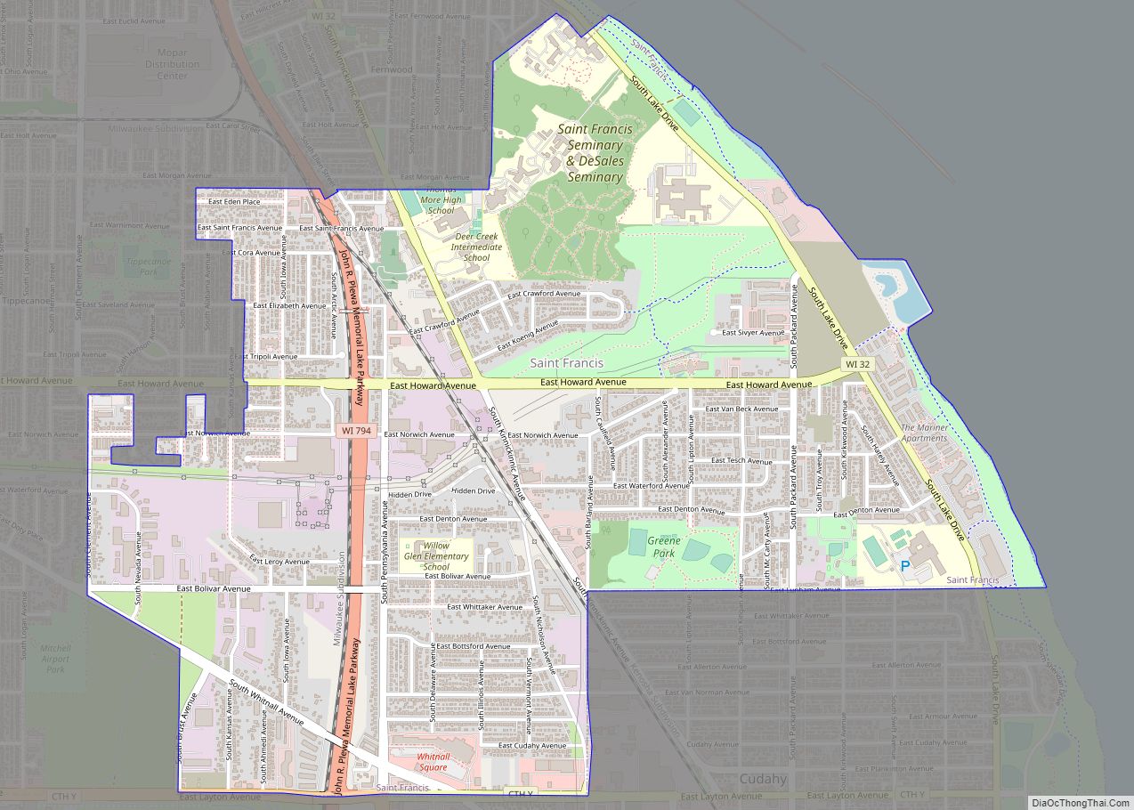
Map of Loyal city, Wisconsin

Map of Loyal city, Wisconsin

Loyal is a city in Clark County in the U.S. state of Wisconsin. The population was 1,261 at the 2010 census. The city is located within the Town of Loyal, though it is politically independent. Its name comes from the 1860s, when so many of its patriotic pioneers went to fight in the Civil War. … Read more

Map of Marion city, Wisconsin

Map of Marion city, Wisconsin

Marion is a city in Shawano and Waupaca counties in the U.S. state of Wisconsin. The population was 1,324 at the 2020 census. Marion city overview: Name: Marion city LSAD Code: 25 LSAD Description: city (suffix) State: Wisconsin County: Shawano County, Waupaca County Elevation: 850 ft (259 m) Total Area: 2.59 sq mi (6.71 km²) Land Area: 2.45 sq mi (6.35 km²) Water … Read more

Map of Lowell village, Wisconsin

Map of Lowell village, Wisconsin

Lowell is a town in Dodge County, Wisconsin, United States. The population was 1,169 at the 2000 census. The Village of Lowell and the unincorporated community of North Lowell are located in the town. Lowell village overview: Name: Lowell village LSAD Code: 47 LSAD Description: village (suffix) State: Wisconsin County: Dodge County FIPS code: 5545950 … Read more

Map of Marinette city

Map of Marinette city

Marinette is a city in and the county seat of Marinette County, Wisconsin, United States. It is located on the south bank of the Menominee River, at its mouth at Green Bay, part of Lake Michigan; to the north is Stephenson Island, part of the city preserved as park. During the lumbering boom of the … Read more

Map of Maribel village

Map of Maribel village

Maribel is a village in Manitowoc County, Wisconsin, United States. The population was 351 at the 2010 census. Maribel village overview: Name: Maribel village LSAD Code: 47 LSAD Description: village (suffix) State: Wisconsin County: Manitowoc County Elevation: 860 ft (262 m) Total Area: 1.15 sq mi (2.97 km²) Land Area: 1.14 sq mi (2.96 km²) Water Area: 0.00 sq mi (0.01 km²) Total Population: 351 Population … Read more

Map of Marengo CDP, Wisconsin

Map of Marengo CDP, Wisconsin

Marengo is an unincorporated census-designated place located in the town of White River, Ashland County, Wisconsin, United States. Marengo is located on Wisconsin Highway 13 10 miles (16 km) northwest of Mellen. Marengo had a post office, which closed on June 27, 2009. At the 2010 census, its population was 111. Bus service to the community … Read more

Map of Marathon City village

Map of Marathon City village

Marathon City is a village in Marathon County, Wisconsin, United States. It is part of the Wausau, Wisconsin Metropolitan Statistical Area. The population was 1,524 at the 2010 census. The village was incorporated from a part of the original area of the town of Marathon. The village dates back to 1856. The name of the … Read more

Map of Maple Bluff village

Map of Maple Bluff village

Maple Bluff is a village in Dane County, Wisconsin, United States. The population was 1,313 at the 2010 census. A suburb of Madison, it is part of the Madison Metropolitan Statistical Area. Maple Bluff is the site of the Wisconsin Governor’s Mansion, the residence of the governor of Wisconsin and their family. The Robert M. … Read more

Map of Manitowoc city

Map of Manitowoc city

Manitowoc (/ˈmænɪtəwɔːk/) is a city in and the county seat of Manitowoc County, Wisconsin, United States. The city is located on Lake Michigan at the mouth of the Manitowoc River. According to the 2020 census, Manitowoc had a population of 34,626, with over 50,000 residents in the surrounding communities. Manitowoc city overview: Name: Manitowoc city … Read more

Map of Mazomanie village

Map of Mazomanie village

Mazomanie is a town in Dane County, Wisconsin. The population was 1,185 at the time of the 2000 census. The Village of Mazomanie is located within the town. Mazomanie village overview: Name: Mazomanie village LSAD Code: 47 LSAD Description: village (suffix) State: Wisconsin County: Dane County FIPS code: 5550225 Online Interactive Map Mazomanie online map. … Read more

Map of Mayville city, Wisconsin

Map of Mayville city, Wisconsin

Mayville is a city in Dodge County, Wisconsin, United States, located along the Rock River and the Horicon Marsh. The population was 5,154 at the 2010 census. Mayville city overview: Name: Mayville city LSAD Code: 25 LSAD Description: city (suffix) State: Wisconsin County: Dodge County Elevation: 929 ft (283 m) Total Area: 3.37 sq mi (8.72 km²) Land Area: 3.25 sq mi … Read more

Map of Merton village

Map of Merton village

Merton is a town in Waukesha County, Wisconsin, United States; before Wisconsin statehood, it was called Warren. The population was 8,277 at the 2020 census. The town surrounds the villages of Chenequa and Merton. The unincorporated communities of Camp Whitcomb, Monches, and North Lake are in the town and the unincorporated community of Stone Bank … Read more