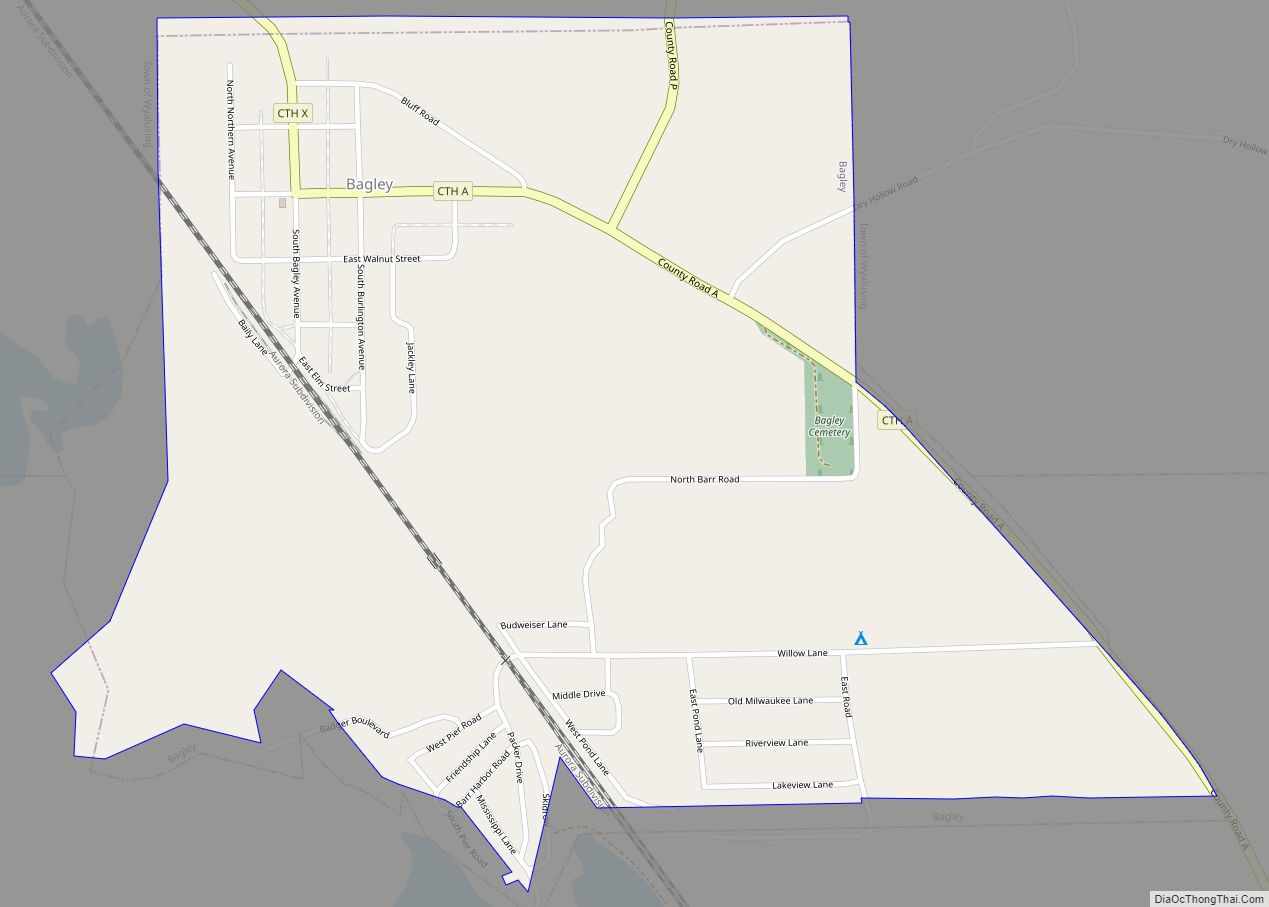
Map of Augusta city, Wisconsin
Augusta is a city in Eau Claire County, Wisconsin, United States. The population was 1,550 at the 2010 census. The city is bordered by the Town of Bridge Creek. Augusta city overview: Name: Augusta city LSAD Code: 25 LSAD Description: city (suffix) State: Wisconsin County: Eau Claire County Elevation: 961 ft (293 m) Total Area: 2.21 sq mi (5.72 km²) ... Read more
Map of Augusta city, Wisconsin
Map of Auburndale village, Wisconsin
Auburndale is a town in Wood County, Wisconsin, United States. The population was 829 at the 2000 census. The Village of Auburndale is located within the town. Auburndale village overview: Name: Auburndale village LSAD Code: 47 LSAD Description: village (suffix) State: Wisconsin County: Wood County Total Area: 32.2 sq mi (83.5 km²) Land Area: 32.2 sq mi (83.5 km²) Total Population: ... Read more
Map of Auburndale village, Wisconsin
Map of Athens village, Wisconsin
Athens is a village in Marathon County, Wisconsin, United States. The population was 1,105 at the 2010 census. It is part of the Wausau, Wisconsin Metropolitan Statistical Area. Athens village overview: Name: Athens village LSAD Code: 47 LSAD Description: village (suffix) State: Wisconsin County: Marathon County Elevation: 1,401 ft (427 m) Total Area: 2.45 sq mi (6.35 km²) Land Area: ... Read more
Map of Athens village, Wisconsin
Map of Ashwaubenon village
Ashwaubenon (/æʃˈwɔːbɪnɒn/) is a village in Brown County in the U.S. state of Wisconsin. The population was 16,963 at the 2010 census. A suburb of Green Bay, Ashwaubenon is part of the Green Bay Metropolitan Statistical Area and carries a Green Bay mailing address. Part of the Oneida Nation of Wisconsin is in Ashwaubenon. Ashwaubenon ... Read more
Map of Ashwaubenon village
Map of Bancroft CDP, Wisconsin
Bancroft is an unincorporated census-designated place in Portage County, Wisconsin, United States. As of the 2010 census, its population is 535. It is included in the Stevens Point, Wisconsin Micropolitan Statistical Area. Bancroft CDP overview: Name: Bancroft CDP LSAD Code: 57 LSAD Description: CDP (suffix) State: Wisconsin County: Portage County Elevation: 1,093 ft (333 m) Total Area: ... Read more
Map of Bancroft CDP, Wisconsin
Map of Arkansaw CDP
Arkansaw is an unincorporated census-designated place in the eastern portion of the town of Waterville, in Pepin County, Wisconsin, United States. Located approximately 3 miles (4.8 km) west of Durand, it has the ZIP code of 54721. As of the 2010 census, its population was 177. From 1881 to 1886, the community was the county seat ... Read more
Map of Arkansaw CDP
Map of Belmont village, Wisconsin
Belmont is a town in Lafayette County, Wisconsin, United States. The population was 767 at the 2010 census, up from 676 at the 2000 census. The village of Belmont is located in the southeastern part of the town. The unincorporated community of Leslie close to the center of the town. Belmont village overview: Name: Belmont ... Read more
Map of Belmont village, Wisconsin
Map of Bellevue village, Wisconsin
Bellevue is a village in Brown County, Wisconsin. It was a town until incorporating as a village on February 14, 2003. The population was 14,570 at the time of the 2010 census. Bellevue is part of the Green Bay metropolitan area. Bellevue sits around 4.34 miles (6.99km) east from central Green Bay. Bellevue village overview: ... Read more
Map of Bellevue village, Wisconsin
Map of Belleville village, Wisconsin
Belleville is a village in Dane and Green counties in the U.S. state of Wisconsin. The population was 2,491 at the 2020 census. Of this, 1,909 were in Dane County, and 582 were in Green County. The Dane County portion of Belleville is part of the Madison Metropolitan Statistical Area, while the Green County portion ... Read more
Map of Belleville village, Wisconsin
Map of Bell Center village
Bell Center is a village in Crawford County, Wisconsin, United States. The population was 117 at the 2010 census. Bell Center village overview: Name: Bell Center village LSAD Code: 47 LSAD Description: village (suffix) State: Wisconsin County: Crawford County Elevation: 719 ft (219 m) Total Area: 5.59 sq mi (14.47 km²) Land Area: 5.55 sq mi (14.37 km²) Water Area: 0.04 sq mi (0.10 km²) Total ... Read more
Map of Bell Center village
Map of Bear Creek village, Wisconsin
Bear Creek is a village in Outagamie County, Wisconsin, United States. The population was 448 at the 2010 census. Bear Creek village overview: Name: Bear Creek village LSAD Code: 47 LSAD Description: village (suffix) State: Wisconsin County: Outagamie County Total Area: 0.92 sq mi (2.39 km²) Land Area: 0.92 sq mi (2.39 km²) Water Area: 0.00 sq mi (0.00 km²) Total Population: 448 Population ... Read more
Map of Bear Creek village, Wisconsin
Map of Bayside village, Wisconsin
Bayside is a village in Milwaukee and Ozaukee counties in the U.S. state of Wisconsin. The population was 4,482 at the 2020 census. Of this, 4,378 were in Milwaukee County, and only 104 were in Ozaukee County. Bayside village overview: Name: Bayside village LSAD Code: 47 LSAD Description: village (suffix) State: Wisconsin County: Milwaukee County, ... Read more
Map of Bayside village, Wisconsin