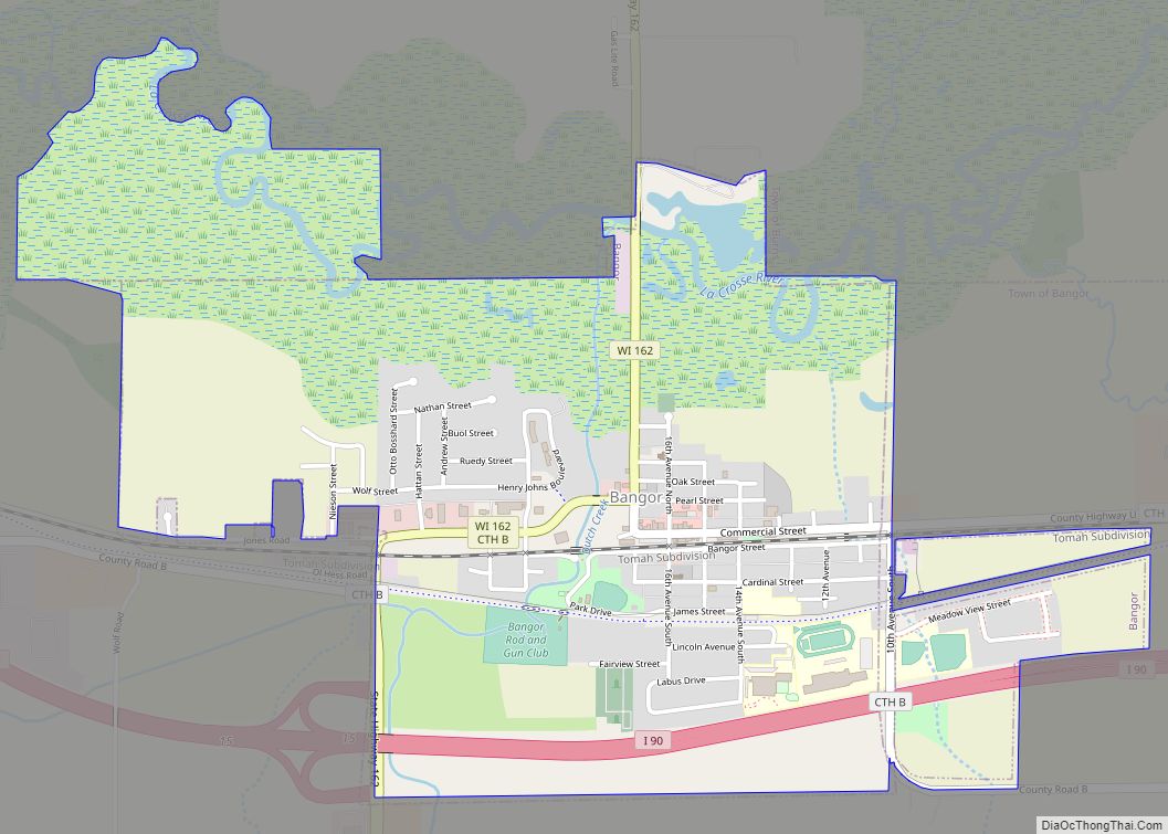
Map of Packwaukee CDP

Map of Packwaukee CDP

Packwaukee is an unincorporated census-designated place located in the town of Packwaukee, Marquette County, Wisconsin, United States. Packwaukee is located on the north bank of Buffalo Lake, a lake on the Fox River; it is 7 miles (11 km) west-southwest of Montello. Packwaukee has a post office with ZIP code 53953. As of the 2010 census, … Read more

Map of Pine River CDP, Wisconsin

Map of Pine River CDP, Wisconsin

Pine River is a census-designated place in Waushara County, Wisconsin, United States. The community is located at the intersection of County H and County E, in the town of Leon. As of the 2010 census, its population is 147. Pine River CDP overview: Name: Pine River CDP LSAD Code: 57 LSAD Description: CDP (suffix) State: … Read more

Map of Oxford village, Wisconsin

Map of Oxford village, Wisconsin

Oxford is a town in Marquette County, Wisconsin, United States. The population was 859 at the 2000 census. The Village of Oxford is located within the town. Oxford village overview: Name: Oxford village LSAD Code: 47 LSAD Description: village (suffix) State: Wisconsin County: Marquette County FIPS code: 5560875 Online Interactive Map Oxford online map. Source: … Read more

Map of Pigeon Falls village

Map of Pigeon Falls village

Pigeon Falls is a village in Trempealeau County, Wisconsin, United States. The population was 411 at the 2010 census. Pigeon Falls village overview: Name: Pigeon Falls village LSAD Code: 47 LSAD Description: village (suffix) State: Wisconsin County: Trempealeau County Elevation: 866 ft (264 m) Total Area: 0.43 sq mi (1.12 km²) Land Area: 0.43 sq mi (1.12 km²) Water Area: 0.00 sq mi (0.00 km²) Total … Read more

Map of Owen city

Map of Owen city

Owen is a city in Clark County in the U.S. state of Wisconsin. The population was 940 at the 2010 census. Owen is located directly east of the village of Withee, which is about half the size of Owen. Owen city overview: Name: Owen city LSAD Code: 25 LSAD Description: city (suffix) State: Wisconsin County: … Read more

Map of Phillips city, Wisconsin

Map of Phillips city, Wisconsin

Phillips is a city and the county seat of Price County, Wisconsin, United States. The population was 1,478 at the 2010 census. Phillips city overview: Name: Phillips city LSAD Code: 25 LSAD Description: city (suffix) State: Wisconsin County: Price County Elevation: 1,444 ft (440 m) Total Area: 3.34 sq mi (8.64 km²) Land Area: 2.63 sq mi (6.81 km²) Water Area: 0.71 sq mi (1.84 km²) … Read more

Map of Pewaukee village

Map of Pewaukee village

Pewaukee is a village in Waukesha County, Wisconsin, United States. The population was 8,238 at the 2020 census. The village is nearly surrounded by the City of Pewaukee. The village was incorporated from what was formerly the Town of Pewaukee, and the remainder of the town later incorporated as a city. Pewaukee village overview: Name: … Read more

Map of Peshtigo city

Map of Peshtigo city

Peshtigo (/ˈpɛʃtɪɡoʊ/ PESH-ti-go) is a city in Marinette County, Wisconsin, United States. The population was 3,420 at the 2020 census The city is surrounded by the Town of Peshtigo. It is part of the Marinette, WI–MI Micropolitan Statistical Area. Peshtigo is known for being the site of the Peshtigo fire of 1871, in which more … Read more

Map of Pepin village

Map of Pepin village

Pepin is a village in Pepin County, Wisconsin, United States. The population was 837 at the 2010 census. The village is located within the Town of Pepin. Pepin village overview: Name: Pepin village LSAD Code: 47 LSAD Description: village (suffix) State: Wisconsin County: Pepin County Elevation: 722 ft (220 m) Total Area: 0.72 sq mi (1.87 km²) Land Area: 0.72 sq mi … Read more

Map of Poplar village, Wisconsin

Map of Poplar village, Wisconsin

Poplar is a village in Douglas County, Wisconsin, United States. The population was 603 at the 2010 census. U.S. Highway 2, County Road D, and County Road P are the main routes in the community. Poplar village overview: Name: Poplar village LSAD Code: 47 LSAD Description: village (suffix) State: Wisconsin County: Douglas County Elevation: 981 ft … Read more

Map of Polonia CDP

Map of Polonia CDP

Polonia is an unincorporated census-designated place in the town of Sharon, Portage County, Wisconsin, United States. It is located on Wisconsin Highway 66 two miles east of Ellis and about 8 miles southwest of Rosholt. Polonia has an area of 3.371 square miles (8.73 km); 3.341 square miles (8.65 km) of this is land, and 0.030 square … Read more

Map of Plymouth city, Wisconsin

Map of Plymouth city, Wisconsin

Plymouth is a city in Sheboygan County, Wisconsin, along the Mullet River. It is included in the Sheboygan, Wisconsin Metropolitan Statistical Area. The city is located in the Town of Plymouth, but is politically independent. Plymouth is known as “Hub City” for its former role as a center of wooden wheelwrighting. The population was 8,932 … Read more