Map of Hyattville CDP
Hyattville is a census-designated place (CDP) in Big Horn County, Wyoming, United States. The population was 75 at the 2010 census. Hyattville CDP overview: Name: Hyattville CDP LSAD Code: 57 LSAD Description: CDP (suffix) State: Wyoming County: Big Horn County Elevation: 4,452 ft (1,357 m) Total Area: 4.1 sq mi (10.5 km²) Land Area: 4.1 sq mi (10.5 km²) Water Area: 0.0 sq mi (0.0 km²) ... Read more
Map of Hyattville CDP
Map of Granger town, Wyoming
Granger is a town along Blacks Fork near the western edge of Sweetwater County, Wyoming, United States. The population was 139 at the 2010 census. It is located near the confluence of the Blacks Fork and the Hams Fork rivers. The geography of the area is flat with semi-arid scrub. Granger town overview: Name: Granger ... Read more
Map of Granger town, Wyoming
Map of Huntley CDP, Wyoming
Huntley is a census-designated place (CDP) in Goshen County, Wyoming, United States. The population was 30 according to the 2010 census. Former Wyoming Governor Stanley K. Hathaway grew up on a farm here, and graduated from Huntley High School as class valedictorian in 1941. He was the only one in his senior class. Huntley CDP ... Read more
Map of Huntley CDP, Wyoming
Map of Hulett town
Hulett is a town in Crook County, Wyoming, United States. The population was 309 at the 2020 census. Hulett town overview: Name: Hulett town LSAD Code: 43 LSAD Description: town (suffix) State: Wyoming County: Crook County Elevation: 3,747 ft (1,142 m) Total Area: 0.86 sq mi (2.23 km²) Land Area: 0.86 sq mi (2.23 km²) Water Area: 0.00 sq mi (0.00 km²) Total Population: 309 Population ... Read more
Map of Hulett town
Map of Hudson town, Wyoming
Hudson is a town in Fremont County, Wyoming, United States. The population was 458 at the 2010 census. Hudson town overview: Name: Hudson town LSAD Code: 43 LSAD Description: town (suffix) State: Wyoming County: Fremont County Elevation: 5,085 ft (1,550 m) Total Area: 0.43 sq mi (1.10 km²) Land Area: 0.43 sq mi (1.10 km²) Water Area: 0.00 sq mi (0.00 km²) Total Population: 458 Population ... Read more
Map of Hudson town, Wyoming
Map of Homa Hills CDP
Homa Hills is a census-designated place (CDP) in Natrona County, Wyoming, United States. It is part of the Casper, Wyoming Metropolitan Statistical Area. The population was 278 at the 2010 census. Homa Hills CDP overview: Name: Homa Hills CDP LSAD Code: 57 LSAD Description: CDP (suffix) State: Wyoming County: Natrona County Elevation: 5,299 ft (1,615 m) Total ... Read more
Map of Homa Hills CDP
Map of Hoback CDP
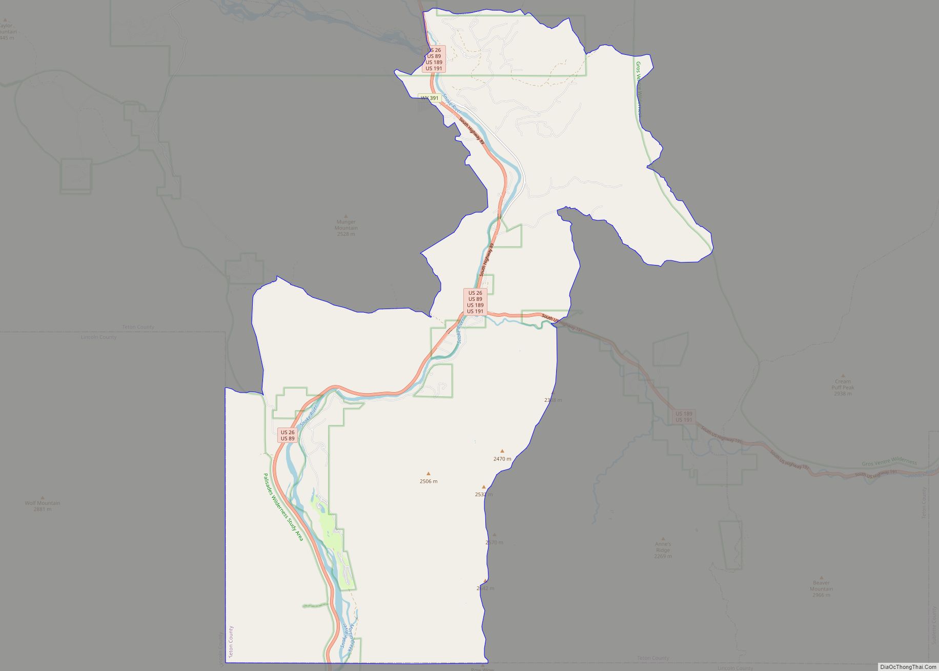
Hoback is a census-designated place (CDP) in Teton County, Wyoming, United States. The population was 1,176 at the 2010 census. It is part of the Jackson, WY–ID Micropolitan Statistical Area. The town is named for John Hoback, a mountain man who guided the Astor party through the area in 1811. Hoback CDP overview: Name: Hoback ... Read more
Map of Hoback CDP
Map of Hillsdale CDP, Wyoming
Hillsdale is an unincorporated community and census-designated place in southeastern Laramie County, Wyoming, United States. As of the 2010 census, it had a population of 47. It lies along local roads east of the city of Cheyenne, the county seat of Laramie County. Its elevation is 5,640 feet (1,720 m) above sea level. Although Hillsdale is ... Read more
Map of Hillsdale CDP, Wyoming
Map of Hill View Heights CDP
Hill View Heights is a census-designated place (CDP) in Weston County, Wyoming, United States. The population was 170 at the 2010 census. Hill View Heights CDP overview: Name: Hill View Heights CDP LSAD Code: 57 LSAD Description: CDP (suffix) State: Wyoming County: Weston County Elevation: 4,344 ft (1,324 m) Total Area: 2.2 sq mi (5.7 km²) Land Area: 2.2 sq mi (5.7 km²) ... Read more
Map of Hill View Heights CDP
Map of Hawk Springs CDP
Hawk Springs is a census-designated place (CDP) in Goshen County, Wyoming, United States. The population was 45 at the 2010 census. Hawk Springs State Recreation Area is located 6 miles (9.7 km) southeast of Hawk Springs. Hawk Springs CDP overview: Name: Hawk Springs CDP LSAD Code: 57 LSAD Description: CDP (suffix) State: Wyoming County: Goshen County ... Read more
Map of Hawk Springs CDP
Map of Hartville town, Wyoming
Hartville is a town in Platte County, Wyoming, United States. The population was 62 at the 2010 census. Hartville town overview: Name: Hartville town LSAD Code: 43 LSAD Description: town (suffix) State: Wyoming County: Platte County Elevation: 4,682 ft (1,427 m) Total Area: 0.26 sq mi (0.67 km²) Land Area: 0.26 sq mi (0.67 km²) Water Area: 0.00 sq mi (0.00 km²) Total Population: 62 Population ... Read more
Map of Hartville town, Wyoming
Map of Hartrandt CDP
Hartrandt is a census-designated place (CDP) in Natrona County, Wyoming, United States. It is part of the Casper, Wyoming Metropolitan Statistical Area and the population was 693 at the 2010 census. Hartrandt CDP overview: Name: Hartrandt CDP LSAD Code: 57 LSAD Description: CDP (suffix) State: Wyoming County: Natrona County Elevation: 5,285 ft (1,611 m) Total Area: 1.56 sq mi ... Read more
Map of Hartrandt CDP