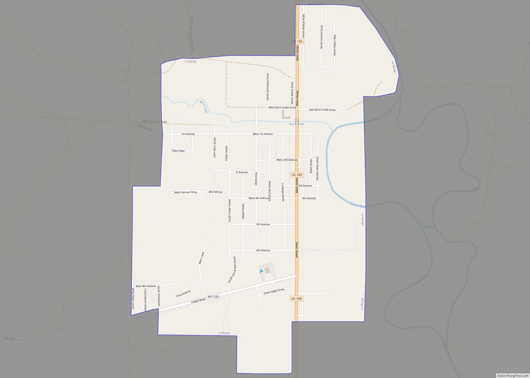
Map of Grover CDP, Wyoming

Map of Grover CDP, Wyoming

Grover is a census-designated place (CDP) in Lincoln County, Wyoming, United States. The population was 147 at the 2010 census. Grover CDP overview: Name: Grover CDP LSAD Code: 57 LSAD Description: CDP (suffix) State: Wyoming County: Lincoln County Elevation: 6,148 ft (1,874 m) Total Area: 0.9 sq mi (2.2 km²) Land Area: 0.9 sq mi (2.2 km²) Water Area: 0.0 sq mi (0.0 km²) Total Population: … Read more

Map of James Town CDP

Map of James Town CDP

James Town is a census-designated place (CDP) in Sweetwater County, Wyoming, United States. The population was 536 at the 2010 census. James Town CDP overview: Name: James Town CDP LSAD Code: 57 LSAD Description: CDP (suffix) State: Wyoming County: Sweetwater County Elevation: 6,165 ft (1,879 m) Total Area: 3.38 sq mi (8.8 km²) Land Area: 3.16 sq mi (8.2 km²) Water Area: 0.22 sq mi … Read more

Map of Greybull town

Map of Greybull town

Greybull is a town in central Big Horn County, Wyoming, United States. The population was 1,847 at the 2010 census. Greybull town overview: Name: Greybull town LSAD Code: 43 LSAD Description: town (suffix) State: Wyoming County: Big Horn County Elevation: 3,789 ft (1,155 m) Total Area: 1.90 sq mi (4.91 km²) Land Area: 1.89 sq mi (4.89 km²) Water Area: 0.01 sq mi (0.02 km²) Total … Read more

Map of Jackson town, Wyoming

Map of Jackson town, Wyoming

Jackson is a town in Teton County, Wyoming, United States. The population was 10,760 at the 2020 census, up from 9,577 in 2010. It is the largest town in Teton County and its county seat. Jackson is the principal town of the Jackson, WY-ID Micropolitan Statistical Area, which includes Teton County in Wyoming and Teton … Read more

Map of Green River city, Wyoming

Map of Green River city, Wyoming

Green River is a city in and the county seat of Sweetwater County, Wyoming, United States, in the southwestern part of the state. The population was 12,515 at the 2010 census. Green River city overview: Name: Green River city LSAD Code: 25 LSAD Description: city (suffix) State: Wyoming County: Sweetwater County Elevation: 6,115 ft (1,864 m) Total … Read more

Map of Hyattville CDP

Map of Hyattville CDP

Hyattville is a census-designated place (CDP) in Big Horn County, Wyoming, United States. The population was 75 at the 2010 census. Hyattville CDP overview: Name: Hyattville CDP LSAD Code: 57 LSAD Description: CDP (suffix) State: Wyoming County: Big Horn County Elevation: 4,452 ft (1,357 m) Total Area: 4.1 sq mi (10.5 km²) Land Area: 4.1 sq mi (10.5 km²) Water Area: 0.0 sq mi (0.0 km²) … Read more

Map of Granger town, Wyoming

Map of Granger town, Wyoming

Granger is a town along Blacks Fork near the western edge of Sweetwater County, Wyoming, United States. The population was 139 at the 2010 census. It is located near the confluence of the Blacks Fork and the Hams Fork rivers. The geography of the area is flat with semi-arid scrub. Granger town overview: Name: Granger … Read more

Map of Huntley CDP, Wyoming

Map of Huntley CDP, Wyoming

Huntley is a census-designated place (CDP) in Goshen County, Wyoming, United States. The population was 30 according to the 2010 census. Former Wyoming Governor Stanley K. Hathaway grew up on a farm here, and graduated from Huntley High School as class valedictorian in 1941. He was the only one in his senior class. Huntley CDP … Read more

Map of Glenrock town

Map of Glenrock town

Glenrock is a town in Converse County, Wyoming, United States. The population was 2,576 at the 2010 census. Glenrock town overview: Name: Glenrock town LSAD Code: 43 LSAD Description: town (suffix) State: Wyoming County: Converse County Elevation: 5,020 ft (1,530 m) Total Area: 2.30 sq mi (5.96 km²) Land Area: 2.30 sq mi (5.96 km²) Water Area: 0.00 sq mi (0.00 km²) Total Population: 2,576 Population … Read more

Map of Hulett town

Map of Hulett town

Hulett is a town in Crook County, Wyoming, United States. The population was 309 at the 2020 census. Hulett town overview: Name: Hulett town LSAD Code: 43 LSAD Description: town (suffix) State: Wyoming County: Crook County Elevation: 3,747 ft (1,142 m) Total Area: 0.86 sq mi (2.23 km²) Land Area: 0.86 sq mi (2.23 km²) Water Area: 0.00 sq mi (0.00 km²) Total Population: 309 Population … Read more

Map of Hudson town, Wyoming

Map of Hudson town, Wyoming

Hudson is a town in Fremont County, Wyoming, United States. The population was 458 at the 2010 census. Hudson town overview: Name: Hudson town LSAD Code: 43 LSAD Description: town (suffix) State: Wyoming County: Fremont County Elevation: 5,085 ft (1,550 m) Total Area: 0.43 sq mi (1.10 km²) Land Area: 0.43 sq mi (1.10 km²) Water Area: 0.00 sq mi (0.00 km²) Total Population: 458 Population … Read more

Map of Homa Hills CDP

Map of Homa Hills CDP

Homa Hills is a census-designated place (CDP) in Natrona County, Wyoming, United States. It is part of the Casper, Wyoming Metropolitan Statistical Area. The population was 278 at the 2010 census. Homa Hills CDP overview: Name: Homa Hills CDP LSAD Code: 57 LSAD Description: CDP (suffix) State: Wyoming County: Natrona County Elevation: 5,299 ft (1,615 m) Total … Read more