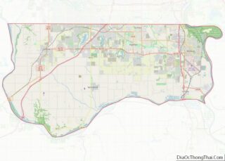
Map of Franklin County

Map of Franklin County, Massachusetts

Franklin County is a nongovernmental county located in the northwestern part of the U.S. state of Massachusetts. As of the 2020 census, the population was 71,029, which makes it the least-populous county on the Massachusetts mainland, and the third-least populous county in the state. Its traditional county seat and most populous city is Greenfield. Its … Read more

Map of Barry County

Map of Barry County, Michigan

Barry County is a county in the U.S. state of Michigan. As of the 2020 United States Census, the population was 62,423. The county seat is Hastings. Barry County overview: Name: Barry County FIPS code: 26-015 State: Michigan Founded: 1829 Named for: William Taylor Barry Seat: Hastings Largest city: Hastings Total Area: 577 sq mi (1,490 km²) Land … Read more

Map of Emmet County

Map of Emmet County, Michigan

Emmet County is a county located in the U.S. state of Michigan. It is the northernmost county in the Lower Peninsula. As of the 2020 Census, the population was 34,112, making it the second-most populous county in Northern Michigan (behind Grand Traverse County). The county seat is Petoskey, which is also the county’s largest city. … Read more

Map of Kalkaska County

Map of Kalkaska County, Michigan

Kalkaska County (/kælˈkæskə/ kal-KASS-kə) is located in the U.S. state of Michigan. As of the 2020 Census, the population was 17,939. The county seat is Kalkaska. Kalkaska County is included in the Traverse City Micropolitan Statistical Area. Although it is located on Michigan’s Lower Peninsula, Kalkaska County is considered part of Northern Michigan. Kalkaska County … Read more

Map of Marquette County

Map of Marquette County, Michigan

Marquette County (/mɑːrˈkɛt/ mar-KEHT) is a county located in the Upper Peninsula of the U.S. state of Michigan. As of the 2020 Census, the population was 66,017. The county seat is Marquette. The county is named for Father Marquette, a Jesuit missionary. It was set off in 1843 and organized in 1851. Marquette County is … Read more

Map of Oscoda County

Map of Oscoda County, Michigan

Oscoda County (/ɒˈskoʊdə/ ah-SKOH-də) is a county in the U.S. state of Michigan. As of the 2020 census, the population was 8,219, making it the least populous county in the Lower Peninsula, and the sixth-least populous county in the entire state. The county seat is Mio, an unincorporated community near the center of the county. … Read more

Map of Aitkin County

Map of Aitkin County, Minnesota

Aitkin County (/ˈeɪkɪn/ AY-kin) is a county in the U.S. state of Minnesota. As of the 2020 census, the population was 15,697. Its county seat is Aitkin. Part of the Mille Lacs Indian Reservation is in the county. The county was created in 1857 and organized in 1871. Aitkin County overview: Name: Aitkin County FIPS … Read more

Map of Cottonwood County

Map of Cottonwood County, Minnesota

Cottonwood County is a county in the U.S. state of Minnesota. As of the 2020 census, the population was 11,517. Its county seat is Windom. Cottonwood County overview: Name: Cottonwood County FIPS code: 27-033 State: Minnesota Founded: 1857 Named for: Cottonwood River Seat: Windom Largest city: Windom Total Area: 649 sq mi (1,680 km²) Land Area: 639 sq mi (1,660 km²) … Read more

Map of Kanabec County

Map of Kanabec County, Minnesota

Kanabec County (/kəˈneɪbɪk/ kə-NAY-bik) is a county in the East Central part of U.S. state of Minnesota. As of the 2020 census, the population was 16,032. Its county seat is Mora. Kanabec County overview: Name: Kanabec County FIPS code: 27-065 State: Minnesota Founded: 1858 Named for: Snake River Seat: Mora Largest city: Mora Total Area: … Read more

Map of Mille Lacs County

Map of Mille Lacs County, Minnesota

Mille Lacs County (/ˌmɪl ˈlæks/ mil LAKS) is a county in the East Central part of the U.S. state of Minnesota. As of the 2020 census, the population was 26,459. Its county seat is Milaca. The county was founded in 1857, and its boundary was expanded in 1860. Mille Lacs County is included in the … Read more

Map of Redwood County

Map of Redwood County, Minnesota

Redwood County is a county in the U.S. state of Minnesota. As of the 2020 census the population was 15,425. Its county seat is Redwood Falls, along the Redwood River near its confluence with the Minnesota River. The Lower Sioux Indian Reservation (also known as the Mdewakankton Tribal Reservation) is entirely within the county, along … Read more

Map of Wadena County

Map of Wadena County, Minnesota

Wadena County (/wəˈdiːnə/ wə-DEEN-ə) is a county in the U.S. state of Minnesota. As of the 2020 census, the population was 14,065. Its county seat is Wadena. Wadena County overview: Name: Wadena County FIPS code: 27-159 State: Minnesota Founded: 1858 Named for: A trading post Seat: Wadena Largest city: Wadena Total Area: 543 sq mi (1,410 km²) Land … Read more