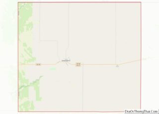
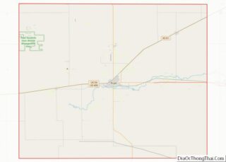
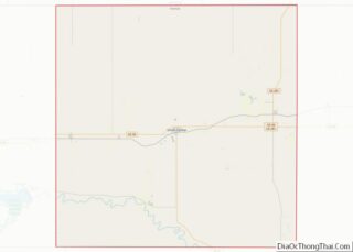
Map of Mercer County

Map of Mercer County, North Dakota

Mercer County is a county in the U.S. state of North Dakota. As of the 2020 census, the population was 8,350. Its county seat is Stanton. Mercer County overview: Name: Mercer County FIPS code: 38-057 State: North Dakota Founded: 1875 Named for: W. H. H. Mercer Seat: Stanton Largest city: Beulah Total Area: 1,112 sq mi (2,880 km²) … Read more

Map of Stark County

Map of Stark County, North Dakota

Stark County is a county in the U.S. state of North Dakota. As of the 2020 census, the population was 33,646. Its county seat is Dickinson. Stark County is part of the Dickinson, ND Micropolitan Statistical Area. Stark County overview: Name: Stark County FIPS code: 38-089 State: North Dakota Founded: 1879 Named for: George Stark … Read more

Map of Brown County

Map of Brown County, Ohio

Brown County is a county in the U.S. state of Ohio. As of the 2020 United States Census, the population was 43,676. The county seat and largest city is Georgetown. The county was created in 1818 and is named for Major General Jacob Brown, an officer in the War of 1812 who was wounded at … Read more

Map of Fayette County

Map of Fayette County, Ohio

Fayette County is a county located in the U.S. state of Ohio. As of the 2020 census, the population was 28,951. Its county seat and largest city is Washington Court House. The county was named for the Marquis de Lafayette, a Frenchman who was an officer in the American Army in the Revolution, when established … Read more

Map of Jackson County

Map of Jackson County, Ohio

Jackson County is a county located in the U.S. state of Ohio. As of the 2020 census, the population was 32,653. Its county seat is Jackson. The county is named for Andrew Jackson, a hero of the War of 1812 who was subsequently elected President of the United States. It is known as “The Little … Read more

Map of Miami County

Map of Miami County, Ohio

Miami County is a county located in the U.S. state of Ohio. As of the 2020 census, the population was 108,774. Its county seat is Troy. The county is named in honor of the Miami people. Miami County is part of the Dayton, OH Metropolitan Statistical Area. Miami County overview: Name: Miami County FIPS code: … Read more

Map of Ross County

Map of Ross County, Ohio

Ross County is a county in the Appalachian region of the U.S. state of Ohio. As of the 2020 United States Census, the population was 77,093. Its county seat is Chillicothe, the first and third capital of Ohio. Established on August 20, 1798, the county is named for Federalist Senator James Ross of Pennsylvania. Ross … Read more

Map of Wood County

Map of Wood County, Ohio

Wood County is a county located in the U.S. state of Ohio. As of the 2020 census, the population was 132,248. Its county seat is Bowling Green. The county was named for Captain Eleazer D. Wood, the engineer for General William Henry Harrison’s army, who built Fort Meigs in the War of 1812. Wood County … Read more

Map of Coal County

Map of Coal County, Oklahoma

Coal County is a county located in the U.S. state of Oklahoma. As of the 2010 census, the population was 5,925. Its county seat is Coalgate. Coal County overview: Name: Coal County FIPS code: 40-029 State: Oklahoma Founded: 1907 Seat: Coalgate Largest city: Coalgate Total Area: 521 sq mi (1,350 km²) Land Area: 517 sq mi (1,340 km²) Total Population: 5,925 … Read more

Map of Haskell County

Map of Haskell County, Oklahoma

Haskell County is a county located in the southeast quadrant of the U.S. state of Oklahoma. As of the 2020 census, the population was 12,652. Its county seat is Stigler. The county is named in honor of Charles N. Haskell, the first governor of Oklahoma. Haskell County overview: Name: Haskell County FIPS code: 40-061 State: … Read more

Map of McClain County

Map of McClain County, Oklahoma

McClain County is a county located in south central Oklahoma. As of the 2020 census, the population was 41,662. Its county seat is Purcell. The county was named for Charles M. McClain, an Oklahoma constitutional convention attendee. McClain County is part of the Oklahoma City, OK Metropolitan Statistical Area. McClain County overview: Name: McClain County … Read more

Map of Pottawatomie County

Map of Pottawatomie County, Oklahoma

Pottawatomie County is a county located in the U.S. state of Oklahoma. As of the 2020 census, the population was 72,454. Its county seat is Shawnee. Pottawatomie County is part of the Shawnee, OK Micropolitan Statistical Area, which is included in the Oklahoma City–Shawnee, OK Combined Statistical Area. Pottawatomie County overview: Name: Pottawatomie County FIPS … Read more