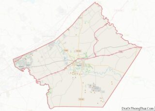
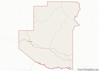
Map of Ringgold County

Map of Ringgold County, Iowa

Ringgold County is a county located in the U.S. state of Iowa. As of the 2020 census, the population was 4,663, making it the Iowa county with the second-smallest population. The county seat is Mount Ayr. The county is named after Maj. Samuel Ringgold, a hero of the Battle of Palo Alto fought in May … Read more

Map of Winneshiek County

Map of Winneshiek County, Iowa

Winneshiek County is a county located in the U.S. state of Iowa. As of the 2020 census, the population was 20,070. The county seat is Decorah. Winneshiek County overview: Name: Winneshiek County FIPS code: 19-191 State: Iowa Founded: 1847 Named for: Chief Winneshiek Seat: Decorah Largest city: Decorah Total Area: 690 sq mi (1,800 km²) Land Area: 690 sq mi … Read more

Map of Clark County

Map of Clark County, Kansas

Clark County (county code CA) is a county located in the U.S. state of Kansas. As of the 2020 census, the county population was 1,991. Its county seat and most populous city is Ashland. Clark County overview: Name: Clark County FIPS code: 20-025 State: Kansas Founded: February 26, 1867 Named for: Charles F. Clarke Seat: … Read more

Map of Ford County

Map of Ford County, Kansas

Ford County overview: Name: Ford County FIPS code: 20-057 State: Kansas Founded: February 26, 1867 Named for: James Ford Seat: Dodge City Largest city: Dodge City Total Area: 1,099 sq mi (2,850 km²) Land Area: 1,098 sq mi (2,840 km²) Total Population: 34,287 Population Density: 31.2/sq mi (12.0/km²) Time zone: UTC−6 (Central) Summer Time Zone (DST): UTC−5 (CDT) Website: fordcounty.net Ford County … Read more

Map of Jewell County

Map of Jewell County, Kansas

Jewell County overview: Name: Jewell County FIPS code: 20-089 State: Kansas Founded: February 26, 1887 Named for: Lewis R. Jewell Seat: Mankato Largest city: Mankato Total Area: 914 sq mi (2,370 km²) Land Area: 910 sq mi (2,400 km²) Total Population: 2,932 Population Density: 3.2/sq mi (1.2/km²) Time zone: UTC−6 (Central) Summer Time Zone (DST): UTC−5 (CDT) Website: jewellcountykansas.net Jewell County location … Read more

Map of Miami County

Map of Miami County, Kansas

Miami County (county code MI) is a county located in east-central Kansas and is part of the Kansas City metropolitan area. As of the 2020 census, the county population was 34,191. Its county seat and most populous city is Paola. Miami County overview: Name: Miami County FIPS code: 20-121 State: Kansas Founded: August 25, 1855 … Read more

Map of Rawlins County

Map of Rawlins County, Kansas

Rawlins County (standard abbreviation: RA) is a county located in the U.S. state of Kansas. As of the 2020 census, the county population was 2,561. The largest city and county seat is Atwood. It was named after Union Civil War General John Aaron Rawlins. Rawlins County overview: Name: Rawlins County FIPS code: 20-153 State: Kansas … Read more

Map of Stafford County

Map of Stafford County, Kansas

Stafford County (standard abbreviation: SF) is a county located in the U.S. state of Kansas. As of the 2020 census, the county population was 4,072. Its county seat is St. John. The county is named in honor of Lewis Stafford, captain of Company E, First Kansas Infantry, who was killed at the Battle of Young’s … Read more

Map of Ballard County

Map of Ballard County, Kentucky

Ballard County is a county located in the extreme west portion of the U.S. state of Kentucky. As of the 2020 census, the population was 7,728. Its county seat is Wickliffe and its largest city is LaCenter. The county was created by the Kentucky State Legislature in 1842 and is named for Captain Bland Ballard, … Read more

Map of Carlisle County

Map of Carlisle County, Kentucky

Carlisle County is a county located in the U.S. state of Kentucky. As of the 2020 census, the population was 4,826, making it the fourth-least populous county in Kentucky. Its county seat is Bardwell. The county was founded in 1886 and named for John Griffin Carlisle, a Speaker of the United States House of Representatives … Read more

Map of Floyd County

Map of Floyd County, Kentucky

Floyd County is a county located in the U.S. state of Kentucky. As of the 2020 census, the population was 35,942. Its county seat is Prestonsburg. The county, founded in 1800, is named for Colonel John Floyd (1750–1783). Floyd County overview: Name: Floyd County FIPS code: 21-071 State: Kentucky Founded: 1800 Named for: John Floyd … Read more

Map of Henry County

Map of Henry County, Kentucky

Henry County is a county located in the north central portion of the U.S. state of Kentucky bordering the Kentucky River. As of the 2020 census, the population was 15,678. Its county seat is New Castle, but its largest city is Eminence. The county was founded in 1798 from portions of Shelby County. It was … Read more