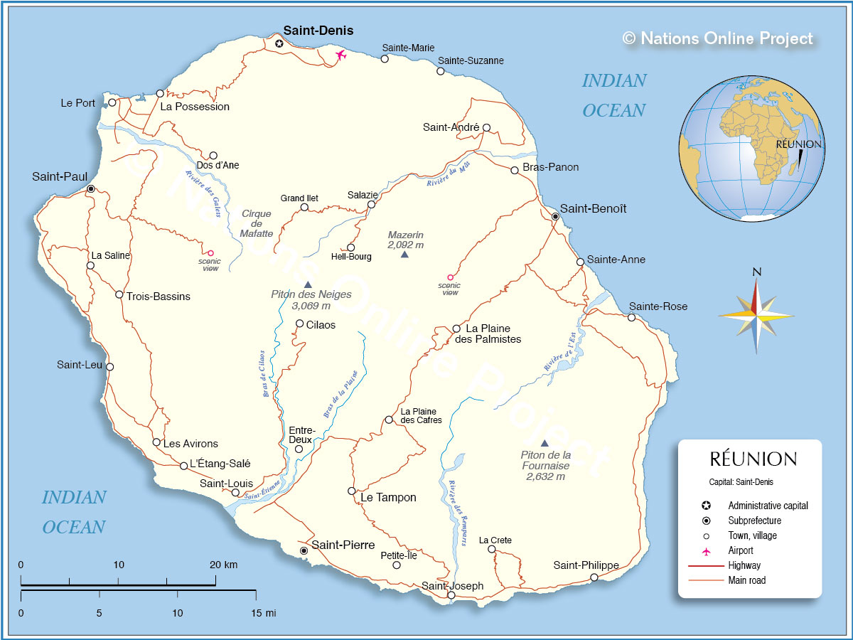
Covering an area of 2,511 sq. km, Reunion Island is an overseas department and a region of France located in the Indian Ocean.
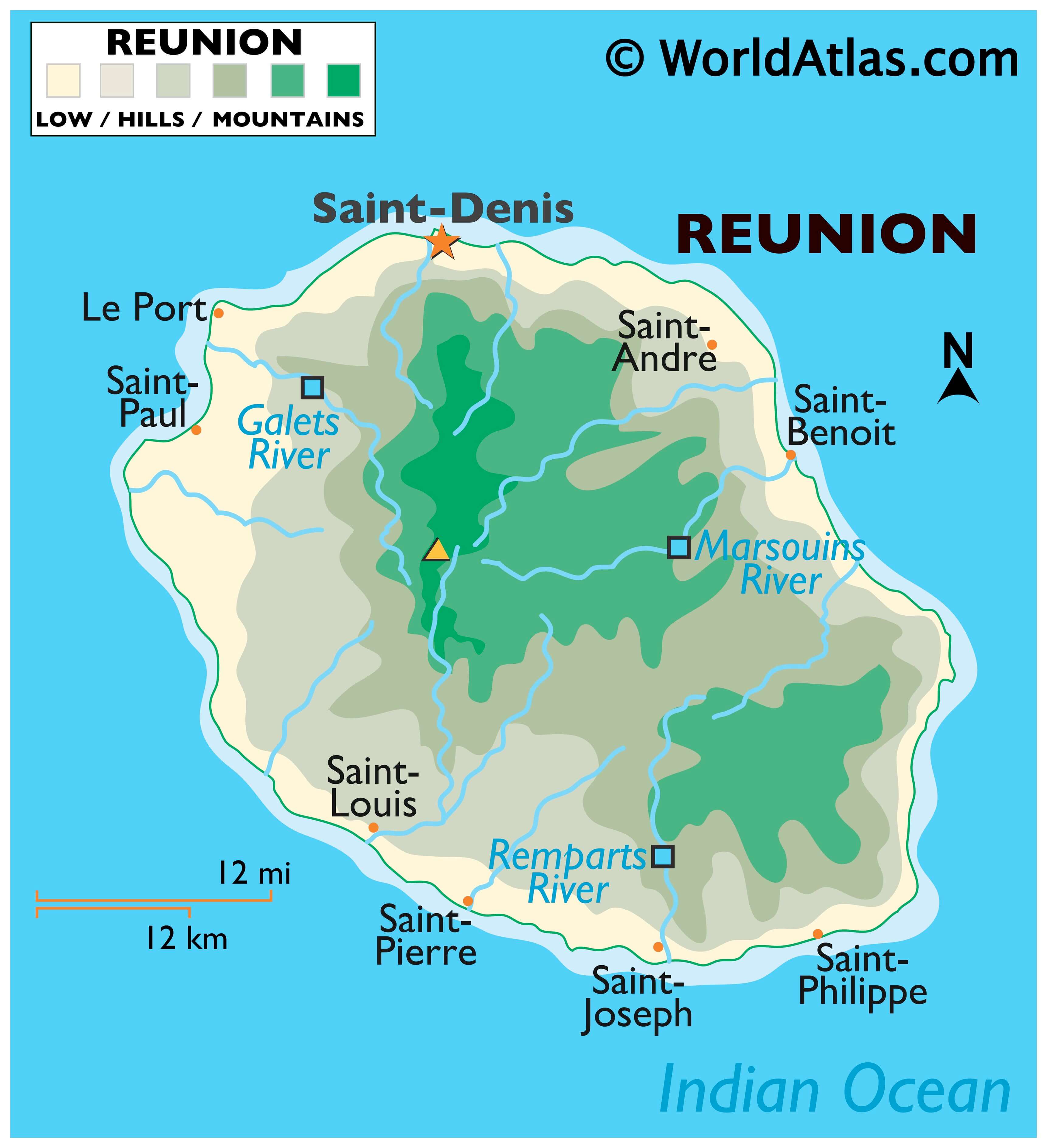
As observed on the map, Reunion is a rugged volcanic island and consists of rugged mountains that are dissected by short rivers. Located in the west-central part of the Island is the Piton des Neiges volcano – the island’s highest point, which rises to an elevation of 10,069ft (3,069m). Situated on the eastern part of the Island is Piton de la fournaise – an active shield volcano. The lowest point is at the Indian Ocean (0ft) (0m).
| Density: | 350/km (900/sq mi) |
|---|
Online Interactive Political Map
Click on ![]() to view map in "full screen" mode.
to view map in "full screen" mode.
Reunion is administratively divided into 4 arrondissements, 24 communes (municipalities) and 49 cantons. In alphabetical order the arrondissements are: Arrondissement of Saint-Benoit (with 6 communes), Arrondissement of Saint-Denis (with 3 communes), Arrondissement of Saint-Paul (with 5 communes) and Arrondissement of Saint-Pierre (with 10 communes).
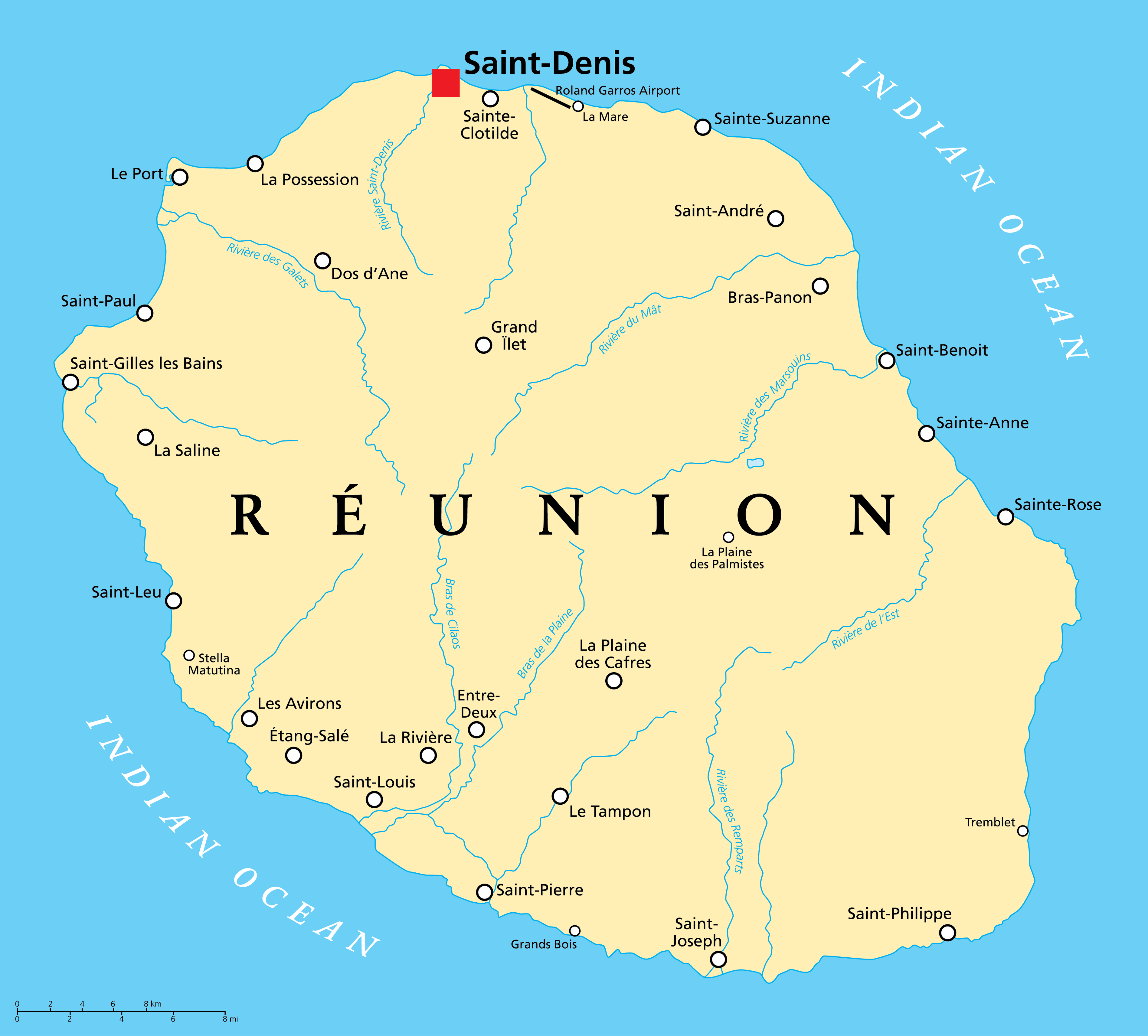
Covering an area of 2,511 sq. km, Reunion Island is an overseas department and a region of France located in the Indian Ocean. Located on the northern coast of the Island is Saint-Denis – the capital town of Reunion. It serves as the principal administrative center of Reunion.
Location Maps
Where is Réunion?
High Definition Political Map of Réunion
Physical Map of Réunion
Geography
The island is 63 km (39 mi) long; 45 km (28 mi) wide; and covers 2,512 km (970 sq mi). It is above a hotspot in the Earth’s crust. The Piton de la Fournaise, a shield volcano on the eastern end of Réunion Island, rises more than 2,631 m (8,632 ft) above sea level and is sometimes called a sister to Hawaiian volcanoes because of the similarity of climate and volcanic nature. It has erupted more than 100 times since 1640, and is under constant monitoring, most recently erupting on 19 September 2022. During another eruption in April 2007, the lava flow was estimated at 3,000,000 m (3,900,000 cu yd) per day. The hotspot that fuels Piton de la Fournaise also created the islands of Mauritius and Rodrigues.
The Piton des Neiges volcano, the highest point on the island at 3,070 m (10,070 ft) above sea level, is northwest of the Piton de la Fournaise. Collapsed calderas and canyons are south west of the mountain. While the Piton de la Fournaise is one of Earth’s most active volcanoes, the Piton des Neiges is dormant. Its name is French for “peak of snows”, but snowfall on the summit of the mountain is rare. The slopes of both volcanoes are heavily forested. Cultivated land and cities like the capital city of Saint-Denis are concentrated on the surrounding coastal lowlands. Offshore, part of the west coast is characterised by a coral reef system. Réunion also has three calderas: the Cirque de Salazie, the Cirque de Cilaos and the Cirque de Mafate. The last is accessible only on foot or by helicopter.
Plaine-des-Palmistes
Cirque de Mafate is a caldera formed from the collapse of the large shield volcano the Piton des Neiges.
Réunion from space (NASA image): The three cirques, forming a kind of three-leafed clover shape, are visible in the central north west of the image. Piton de la Fournaise is in the south east.
Lava flow emitted in 2005 by the Piton de la Fournaise
“Plage de l’Ermitage” beach
Geology and relief
Reunion Island is a volcanic island born some three million years ago with the emergence of the Piton des Neiges volcano.It has an altitude of 3,070.50 m, the highest peak in the Mascarene Islands and the Indian Ocean. The eastern part of the island is constituted by the Piton de la Fournaise, a much more recent volcano (500,000 years old) which is considered one of the most active on the planet. The emerged part of the island represents only a small percentage (about 3%) of the underwater mountain that forms it.
In addition to volcanism, the relief of the island is very uneven due to active erosion. The center shelters three vast cirques dug by erosion (Salazie, Mafate and Cilaos) and the slopes of the island are furrowed by numerous rivers digging gullies, estimated at least 600, generally deep and whose torrents cut the sides of the mountains up to several hundreds of meters deep.
The ancient massif of the Piton des Neiges is separated from the massif of La Fournaise by a gap formed by the plaine des Palmistes and the plaine des Cafres, a passageway between the East and the South of the island. Apart from the plains, the coastal areas are generally the flattest regions, especially in the north and west of the island. The coastline of the wild south is however steeper.
Between the coastal fringe and the Hauts, there is a steep transitional zone whose gradient varies considerably before arriving at the ridge lines setting the cirques or the Enclos, the caldera of the Piton de la Fournaise.
Climate
The island of Reunion is characterized by a humid tropical climate, tempered by the oceanic influence of the trade winds blowing from east to west. The climate of Reunion is characterized by its great variability, mainly due to the imposing relief of the island, which is at the origin of numerous microclimates.
As a result, there are strong disparities in rainfall between the windward coast in the east and the leeward coast in the west, and in temperature between the warmer coastal areas and the relatively cooler highland areas.
In Réunion there are two distinct seasons, defined by the rainfall regime:
- a rainy season from January to March, during which most of the year’s rain falls;
- a dry season from May to November. However, in the eastern part and in the foothills of the volcano, rainfall can be significant even in the dry season;
April and December are transition months, sometimes very rainy but also very dry.
Pointe des Trois Bassins, located on the coast of the commune of Trois-Bassins (West), is the driest season, with a normal annual precipitation of 447.7 mm (17.63 in), while Le Baril, in Saint-Philippe (Southeast), is the wettest coastal season, with a normal annual precipitation of 4,256.2 mm (167.57 in).
However, the wettest station is in the highlands of Sainte-Rose, with an average annual rainfall of almost 11,000 mm (430 in), making it one of the wettest places in the world.
Temperatures in Reunion are characterized by their great mildness throughout the year. In fact, the thermal amplitude from one season to another is relatively small (rarely exceeding 10 °C or 18 °F), although it is perceptible:
- In the warm season (November to April): average minimums usually range between 21 and 24 °C (70 and 75 °F), and average maximums between 28 and 31 °C (82 and 88 °F), on the coast. At 1,000 m (3,300 ft), average minimums fluctuate between 10 and 14 °C (50 and 57 °F) and average maximums between 21 and 24 °C (70 and 75 °F);
- In the cold season (May to October): temperatures at sea level vary from 17 to 20 °C (63 to 68 °F) for average minimums and from 26 to 28 °C (79 to 82 °F) for average maximums. At 1,000 m (3,300 ft), average minimums range from 8 to 10 °C (46 to 50 °F) and average maximums from 17 to 21 °C (63 to 70 °F).
In mountain towns, such as Cilaos or La Plaine-des-Palmistes, average temperatures range between 12 and 22 °C (54 and 72 °F). The highest parts of the habitat and the natural areas at altitude may suffer some winter frosts. Snow was even observed on the Piton des Neiges and Piton de la Fournaise in 2003 and 2006.
The warmest day on record set on 30 January 2022. In the cold pole of the Reunion Island (all-time low -5C) Gite de Bellecombe (2245m asl) with a max. temperature of 25.4C on 30 January. It beats the previous record of 25.1C set in 2021 and 2021.
While a growing number of islands (including “non-sovereign” islands) in the world are concerned about the effects of climate change, the island of Reunion was chosen (along with Gran Canaria in Spain) as an example for a case study of an affected ultra-European peripheral territory, for a study on the adequacy of urban and regional planning tools to the needs and characteristics of these islands (including land use and population density and the regulatory framework).
This work confirmed that urban and peri-urban land use pressures are high, and that adaptation strategies are incompletely integrated into land use planning. According to the Institute of Island Studies, there is a dysfunction: “island planning tools often do not take climate change adaptation into account and there is too much top-down management in the decision-making process”. Réunion holds the world records for the most rainfall in 12-, 24-, 72- and 96-hour periods, including nearly 6 ft (1.8 meters) in 24 hours.
Beaches
Réunion hosts many tropical and unique beaches. They are often equipped with barbecues, amenities, and parking spaces. Hermitage Beach is the most extensive and best-preserved lagoon in Réunion Island and a popular snorkelling location. It is a white sand beach lined with casuarina trees under which the locals often organise picnics. La Plage des Brisants is a well-known surfing spot, with many athletic and leisurely activities taking place. Each November, a film festival is also organised in La Plage des Brisant’s. Movies are projected on a large screen in front of a crowd. Beaches at Boucan Canot are surrounded by a stretch of restaurants that particularly cater to tourists. L’Étang-Salé on the west coast is a particularly unique beach as it is covered in black sand consisting of tiny fragments of basalt. This occurs when lava contacts water, it cools rapidly and shatters into the sand and fragmented debris of various size. Much of the debris is small enough to be considered sand. Grand Anse is a tropical white-sand beach lined with coconut trees in the south of Réunion, with a rock pool built for swimmers, a pétanque playground, and a picnic area. Le Vieux Port in Saint Philippe is a green-sand beach consisting of tiny olivine crystals, formed by the 2007 lava flow, making it one of the youngest beaches on Earth.
Sunset at Grand Anse beach Reunion Island
Restaurants along Boucan Canot beach
Manapany beach rock pool
L’Étang-Salé Beach – a black sand beach from volcanic basalt
L’Ermitage les Bains lagoon in front of Saint Paul, and its pass through the coral reef