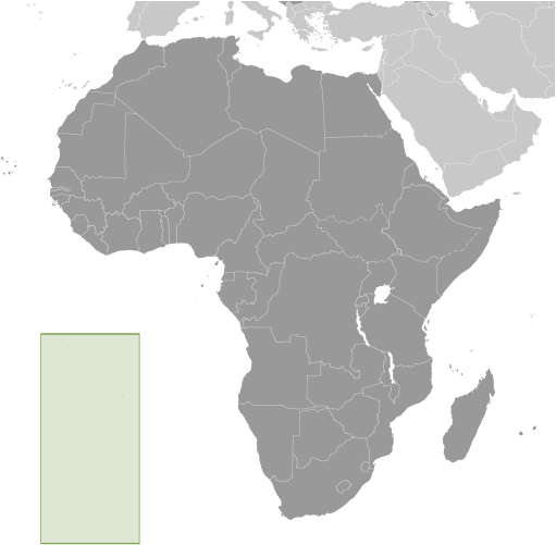
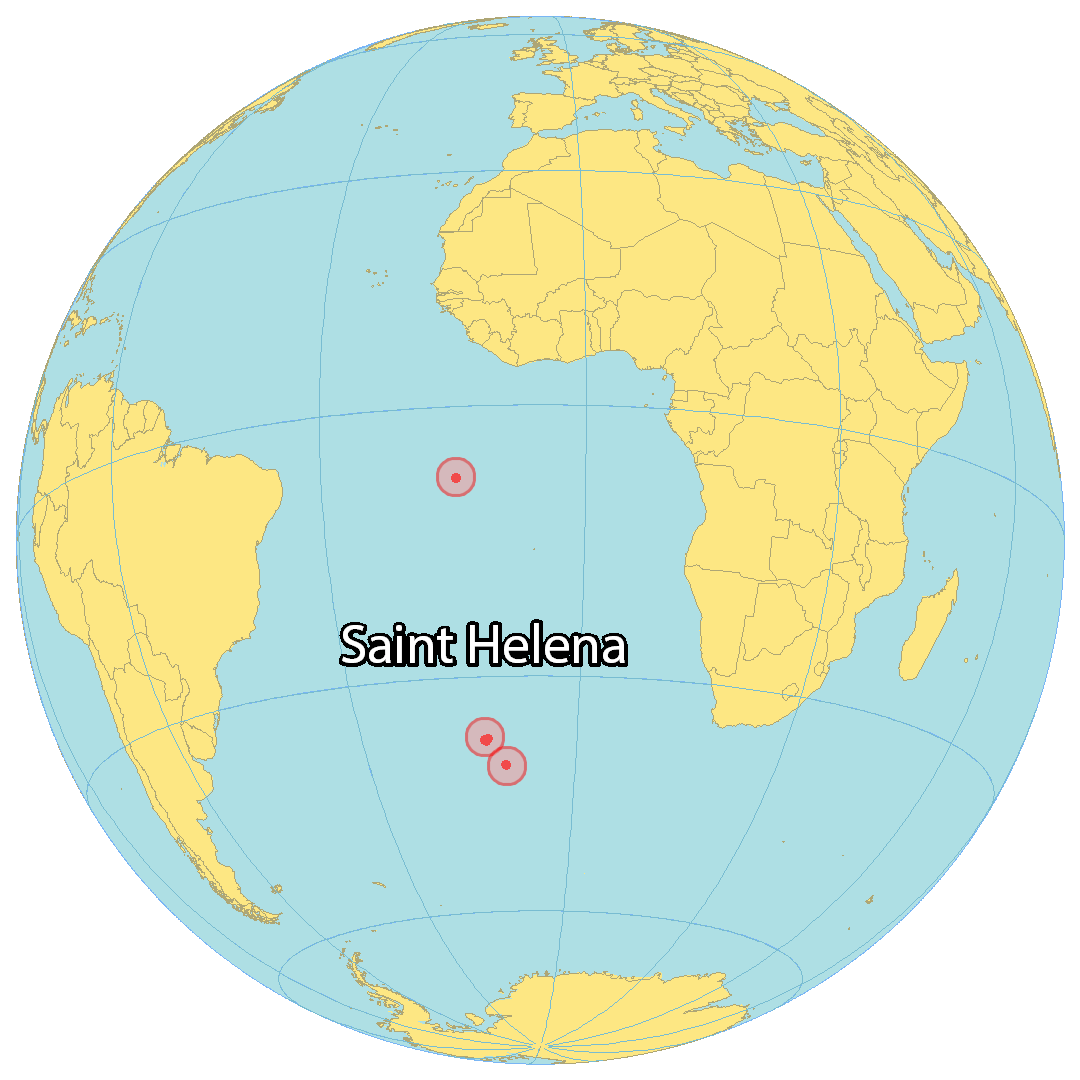
Saint Helena (/həˈliːnə/) is a British overseas territory located in the South Atlantic Ocean. It is a remote volcanic tropical island 1,950 kilometres (1,210 miles) west of the coast of south-western Africa, and 4,000 kilometres (2,500 mi) east of Rio de Janeiro in South America. It is one of three constituent parts of the British Overseas Territory of Saint Helena, Ascension and Tristan da Cunha.
Saint Helena measures about 16 by 8 kilometres (10 by 5 mi) and has a population of 4,439 per the 2021 census. It was named after Helena, mother of Constantine I. It is one of the most remote islands in the world and was uninhabited when discovered by the Portuguese enroute to the Indian subcontinent in 1502. For about four centuries the island was an important stopover for ships from Europe to Asia and back, while sailing around the African continent, until the opening of the Suez canal. St Helena is the United Kingdom‘s second-oldest overseas territory after Bermuda.
Saint Helena is known for being the site of Napoleon’s second exile, following his final defeat in 1815.
| Flag: | 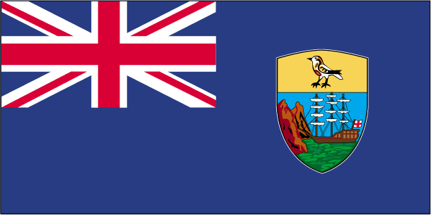 |
|---|---|
| Capital Value: | Jamestown |
| Official languages: | English |
| Demonym(s): |
|
| Government: | Devolved parliamentary dependency under a constitutional monarchy |
| Legislature: | Legislative Council |
| Density: | 36.5/km (94.5/sq mi) |
| Currency Value: | Saint Helena pound (£) (SHP) |
| Driving side: | left |
| Calling code: | +290 |
| Internet TLD: | .sh |
Located in the middle of the South Atlantic Ocean, the remote island of Saint Helena is a place of stunning beauty. With its rugged terrain and lush vegetation, the island is home to some of the most breathtaking landscapes on the planet. From its secluded beaches and coves, to its towering mountains and lush valleys, Saint Helena is a place of unparalleled beauty and serenity.
The island of Saint Helena is home to an array of stunning bays and coves, which offer visitors a chance to explore the island’s unique marine life. From the crystal clear waters of Sandy Bay to the sheltered waters of Rupert’s Bay, the bays and coves of Saint Helena provide a unique opportunity to experience the island’s stunning beauty.
The island of Saint Helena is also home to a number of settlements, airports, roads, and mountains. The settlements of Longwood, Jamestown, and Half Tree Hollow are the most prominent settlements on the island, while the airports of Wideawake and Saint Helena provide access to the island. The roads of the island provide access to many of the settlements, while the mountains of Diana’s Peak and Prosperous Bay Hill offer visitors stunning views of the island.
Saint Helena is a remote island of breathtaking beauty, with its rugged terrain, lush vegetation, and stunning bays and coves. The island is home to settlements, airports, roads, and mountains, providing visitors with a unique opportunity to experience the island’s unique beauty. From crystal clear waters to towering mountains, Saint Helena is a place of unparalleled beauty and serenity.
Online Interactive Political Map
Click on ![]() to view map in "full screen" mode.
to view map in "full screen" mode.
Location Maps
Where is Saint Helena?
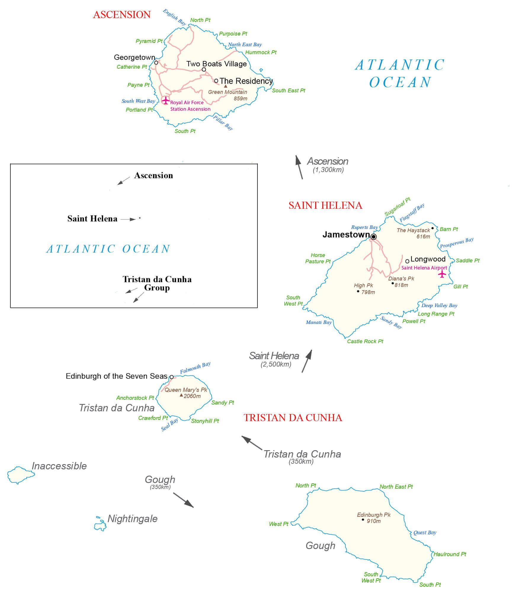
Saint Helena is a British Overseas Territory in the South Atlantic Ocean. It consists of 4 main islands spread out 3,650 kilometers from north to south – Ascension, Saint Helena, Tristan de Cuhna, and Gough. Ascension is the northmost island, located 2,300 kilometers off the coast of Brazil to the west. Saint Helena is the center island, approximately 1,850 kilometers away from Angola, Africa to the east. The capital of Saint Helena is Jamestown, but Half Tree Hollow, a suburb of Jamestown, is the largest settlement. The archipelago of Tristan da Cunha includes Gough Island, which is the southernmost island, 2600 kilometers away from South Africa. Nightingale Island is an active volcano, while Inaccessible Island is an extinct volcano. Both of these minor islands are situated close to Tristan da Cunha. The islands are between 7°S and 40°S latitude from Ascension to Gough Island.
High Definition Political Map of Saint Helena
History
Early history (1502–1658)
By long tradition the island was sighted on 21 May 1502 by the four ships of the 3rd Portuguese Armada commanded by Galician navigator João da Nova during the return voyage to Lisbon, and that he named it Santa Helena after Saint Helena of Constantinople. This tradition has been reviewed by a 2022 paper which concluded the Portuguese chronicles published at least 50 years later, are the sole primary source to the discovery. Although contradictory in describing other events, these chronicles almost unanimously claim João da Nova found St Helena sometime in 1502, although none quote the precise date.
However, there are several reasons for doubting da Nova made this discovery. First, given that da Nova either returned on 11 September or 13 September 1502 it is usually assumed the Cantino planisphere completed by the following November includes his discovery of Ascension Island (shown as an archipelago with one of six islands marked as “ilha achada e chamada Ascenssam”), yet this map fails to show St Helena. Second, when a section of the Fourth Armada under the command of Estêvão da Gama sighted and landed at St Helena the following year on 30 July 1503 its scrivener Thomé Lopes regarded it as an unknown island yet named Ascension as one of five reference points to the new island’s location. On 12 July 1503, nearly three weeks before reaching St Helena, Lopes described how Estêvão da Gama’s ships met up with a section of the Fifth Armada led by Afonso de Albuquerque off the Cape of Good Hope. The latter left Lisbon about six months after João da Nova’s return so Albuquerque and his captains should all have known whether João da Nova had indeed found St Helena. An anonymous Flemish traveler on one of da Gama’s ships reporting that bread and victuals were running short by the time they reached the Cape, so from da Gama’s perspective there was a pressing need that he be told water and meat could be found at St Helena. The fact that nothing seems to have been said about the island, da Gama’s scrivener Lopes regarding the island as unknown, again implies da Nova found Ascension but not St Helena. The 2022 paper also reviews cartographic evidence that St Helena and Ascension were known to the Spanish in 1500, before either João da Nova or Estêvão da Gama sailed for India. The suggestion that João da Nova discovered Tristan da Cunha naming it St Helena is discounted.
A 2015 paper notes that 21 May is the Orthodox and Protestant feast day, opposing the Catholic one in August, and the day and the month was first quoted in 1596 by Jan Huyghen van Linschoten, who was probably mistaken because the island was discovered several decades before the Reformation and the start of Huyghen’s faith of Protestantism. An alternative discovery date of 3 May is suggested as being historically more credible; it is the Catholic feast day of the finding of the True Cross by Saint Helena in Jerusalem, and cited by Odoardo Duarte Lopes and Sir Thomas Herbert.
When Linschoten arrived on 12 May 1589 he reported seeing carvings made by visiting seamen on a fig tree that were dated as early as 1510. The Portuguese probably planted saplings rather than mature trees, and for these to be sufficiently large by 1510 to carry carvings suggests the plants were shipped to the island and planted there some years earlier, possibly within a few years of discovery.
A third discovery story, told by the 16th-century historian Gaspar Correia, holds that the island was found by the Portuguese nobleman and warrior Dom Garcia de Noronha, who sighted the island on his way to India in late 1511 or early 1512. His pilots entered the island onto their charts and it has been suggested that this event was likely decisive in leading to the utilisation of the island as a regular stopover for rest and replenishment for ships en route from India to Europe, from that date until well into the seventeenth century. An analysis has been published of the Portuguese ships arriving at St Helena in the period 1502–1613.
The Portuguese found the island uninhabited, with an abundance of trees and fresh water. They imported livestock, fruit trees and vegetables, and built a chapel and one or two houses. The long tradition that João da Nova built a chapel from one of his wrecked carracks has been shown to be based on a misreading of the records. They formed no permanent settlement, but the island was an important rendezvous point and source of food for ships travelling by Cape Route from Asia to Europe, and frequently sick mariners were left on the island to recover before taking passage on the next ship to call at the island.
Englishman Sir Francis Drake probably located the island on the final leg of his circumnavigation of the world (1577–1580). Further visits by other English explorers followed and, once Saint Helena’s location was more widely known, English ships of war began to lie in wait in the area to attack Portuguese India carracks on their way home.
In developing their Far East trade, the Dutch also began to frequent the island. The Portuguese and Spanish soon gave up regularly calling at the island, partly because they used ports along the West African coast, but also because of attacks on their shipping, the desecration of their chapel and religious icons, killings of their livestock, and destruction of their plantations by Dutch pirates.
The Dutch Republic formally claimed Saint Helena in 1633, although there is no evidence that they ever occupied it. The Dutch lost interest in the island after establishing their colony at the Cape of Good Hope.
East India Company (1658–1815)
In 1657, Oliver Cromwell granted the East India Company (EIC) a charter to govern Saint Helena and, the following year, the company decided to fortify the island and settle it with planters. A tradition, which had its origins in the early 20th century, that the early settlers included many who had lost their homes in the 1666 Great Fire of London, was shown to be a myth in 1999.
The first governor, Captain John Dutton, arrived in 1659, making Saint Helena one of Britain’s earliest colonies outside North America and the Caribbean. A fort and houses were built: Jamestown had been founded, “in the narrow valley between steep cliffs”.
After the Restoration of the English monarchy in 1660, the East India Company received a royal charter, giving it the sole right to fortify and colonise the island. The fort was renamed James Fort and the town was called Jamestown, in honour of the Duke of York, later King James II.
Between January and May 1673, the Dutch East India Company seized the island, but English reinforcements restored East India Company control. The island was fortified with approximately 230 gun turrets.
The British government sent some settlers and gave them land that they could farm but the company experienced difficulty attracting an adequate number of immigrants, in spite of advertisements in London and free tracts of land. By 1670, the population was only 66, including slaves. There was also unrest and rebellion among the inhabitants. Ecological problems, such as deforestation, soil erosion, vermin and drought, led Governor Isaac Pyke to suggest in 1715 that the population be moved to Mauritius, but that was not acted upon. The company continued to subsidise the community because of the island’s strategic location. A census in 1723 recorded 1,110 inhabitants, including 610 slaves.
In the peak era, a thousand ships per year stopped there leaving the governor to try to police the numerous visitors and to limit the consumption of arrack, made from potatoes. Two mutinies occurred, perhaps fueled by alcohol. Because Jamestown was “too raucous with its taverns and brothels”, St Paul’s Cathedral was built outside the town.
Eighteenth-century governors tried to tackle the island’s problems by planting trees, improving fortifications, eliminating corruption, building a hospital, tackling the neglect of crops and livestock, controlling the consumption of alcohol, and introducing legal reforms. The island enjoyed a lengthy period of prosperity from about 1770. Captain James Cook visited the island in 1775 on the final leg of his second circumnavigation of the world. St. James’ Church was built in Jamestown in 1774, and Plantation House in 1791–1792; the latter has since been the official residence of the Governor.
Edmond Halley visited Saint Helena on leaving the University of Oxford in 1676, and set up an astronomical observatory with a 7.3-metre-long (24 ft) aerial telescope, intending to study the stars of the Southern Hemisphere. The site of this telescope is near Saint Mathew’s Church in Hutt’s Gate in the Longwood district. The 680-metre-high (2,230 ft) hill there is called Halley’s Mount.
Throughout that period, Saint Helena was an important port of call of the East India Company. East Indiamen would stop there on the return leg of their voyages to British India and China. At Saint Helena, ships could replenish supplies of water and provisions and, during wartime, form convoys that would sail under the protection of vessels of the Royal Navy.
Captain James Cook’s ship HMS Endeavour anchored and resupplied off the coast of Saint Helena in May 1771 on its return from the European discovery of the east coast of Australia and the rediscovery of New Zealand.
The importation of slaves was made illegal in 1792. Governor Robert Patton (1802–1807) recommended that the company import workers from China to supplement the rural workforce. Many were allowed to stay, and their descendants became integrated into the population. In 1810, Chinese labourers began arriving, and by 1818, 650 were in St Helena. An 1814 census recorded 3,507 people on the island. Many of the labourers were allowed to stay, even though there was less need for their services by 1836.
British rule (1815–1821) and Napoleon’s exile
In 1815, the British government selected Saint Helena as the place of exile for Napoleon Bonaparte, after the Battle of Waterloo, his second abdication (on 22 June 1815) and his final surrender, to Captain Frederick Maitland, on HMS Bellerophon (15 July 1815). He was taken to the island in October 1815. Napoleon stayed at the Briars pavilion, on the grounds of the Balcombe family’s home, until his permanent residence at Longwood House was completed in December 1815. He died there on 5 May 1821.
British East India Company (1821–1834)
Following Napoleon’s death, the soldiers and other temporary residents linked to his presence on the island were withdrawn and the East India Company resumed full control of Saint Helena. Between 1815 and 1830, the EIC made the packet schooner St Helena available to the government of the island, which made multiple trips per year between the island and the Cape, carrying passengers both ways and supplies of wine and provisions back to the island. Napoleon praised Saint Helena’s coffee during his exile on the island, and the product enjoyed a brief popularity in Paris in the years after his death.
The importation of slaves to Saint Helena was banned in 1792. In 1818, the governor freed children born of slaves on the island. The phased emancipation of over 800 resident slaves took place in 1827, some six years before the British parliament passed legislation to abolish slavery in the colonies.
Between 1791 and 1833, Saint Helena became the site of a series of experiments in conservation, reforestation, and attempts to boost rainfall artificially. This environmental intervention was closely linked to the conceptualisation of the processes of environmental change and helped establish the roots of environmentalism.
Crown colony (1834–1981)
Under the provisions of the 1833 India Act, control of Saint Helena passed from the East India Company to the British Crown, and it became a crown colony. Subsequent administrative cost-cutting triggered a long-term population decline: those who could afford to do so tended to leave the island for better opportunities elsewhere. The latter half of the 19th century saw the advent of steamships not reliant on trade winds, as well as the diversion of Far East trade away from the traditional South Atlantic shipping lanes to a route via the Red Sea (which, prior to the building of the Suez Canal, involved a short overland section).
In 1840, a British naval station established to suppress the Atlantic slave trade was based on the island, and between 1840 and 1849 over 15,000 freed slaves, known as “Liberated Africans”, were landed there.
In 1858, the French emperor Napoleon III purchased, in the name of the French government, Longwood House and the lands around it, the last residence of Napoleon I (who died there in 1821; his remains had been returned to France in 1840.) It is still French property, administered by a French representative and under the authority of the French Ministry of Foreign Affairs.
A 2020 report states that the island’s prosperity ended after 1869 when “the Suez Canal shifted trade routes north”. A 2019 report explained that “ships no longer needed a stopping point on a longer journey to Europe”. The number of ships calling at the island fell from 1,100 in 1855 to only 288 in 1889.
On 11 April 1898 American Joshua Slocum, on his solo round-the-world voyage, arrived at Jamestown. He departed on 20 April 1898 for the final leg of his circumnavigation, having been extended hospitality by the governor, Sir R A Standale. He presented two lectures on his voyage and was invited to Longwood by the French Consular agent.
By the end of 1899, St Helena was connected to London by undersea cable; this allowed for telegraph communication. In 1900 and 1901, over 6,000 Boer prisoners were held on the island, during the Second Anglo-Boer War. A 2019 report states that “no traces remain of the two POW camps”, but adds that “the Boer Cemetery is a poignant spot”. Among the notables were Piet Cronjé and his wife after their defeat at the Battle of Paardeberg. The resulting population reached an all-time high of 9,850 in 1901. By 1911, however, that had declined to 3,520 people. In 1906, the British government withdrew the garrison; when spending by the soldiers stopped, there was a negative impact on the economy.
A local industry manufacturing fibre from New Zealand flax was successfully re-established in 1907 and generated considerable income during the First World War. Ascension Island was made a dependency of Saint Helena in 1922, and Tristan da Cunha followed in 1938. During the Second World War, the United States built Wideawake airport on Ascension in 1942, but no military use was made of Saint Helena except maintenance of its defences.
Attendance at school became mandatory in 1942, for ages 5 to 15 in 1941 and the government took over control of the education system. The first secondary school opened in 1946. In the same year, the Americans built Wideawake Airfield (RAF Ascension Island) and that project generated numerous jobs for St Helena; the sale of flax for rope also generated revenue for the island. However, the industry declined after 1951 because of transport costs and competition from synthetic fibres. The decision in 1965 by the British Post Office to use synthetic fibres for its mailbags was a further blow, contributing to the closure of the island’s flax mills in 1965.
From 1958, the Union Castle shipping line gradually reduced its service calls to the island. Curnow Shipping, based in Avonmouth, replaced the Union-Castle Line mailship service in 1977, using the RMS (Royal Mail Ship) St Helena which was introduced in 1989.
1981 to present
The British Nationality Act 1981 reclassified Saint Helena and the other Crown colonies as British Dependent Territories. For the next 20 years, many could find only low-paid work with the island government, and the only available employment outside Saint Helena was on the Falkland Islands and Ascension Island. The Development and Economic Planning Department (which still operates) was formed in 1988 to contribute to raising the living standards of the people of Saint Helena.
It was not until 1992 that the Commission on Citizenship was established, restoring the islanders’ rights including the right of abode. In 2002, the right to British citizenship was restored.
In 1989, Prince Andrew launched the replacement RMS St Helena to serve the island; the vessel was specially built for the Cardiff–Cape Town route and featured a mixed cargo/passenger layout.
The Saint Helena Constitution took effect in 1989 and provided that the island would be governed by a Governor, Commander-in-Chief, and an elected executive and legislative council. In 2002, the British Overseas Territories Act 2002 granted full British citizenship to the islanders and renamed the dependent territories (including Saint Helena) the British Overseas Territories. In 2009, The St Helena, Ascension and Tristan da Cunha Constitution Order 2009 gave all three equal status; the British Overseas Territory was renamed Saint Helena, Ascension and Tristan da Cunha.
In 2021, a ministerial system was introduced in Saint Helena after UK’s approval of a constitution amendment.