Martinique (/ˌmɑːrtɪˈniːk/ MAR-tin-EEK, French: [maʁtinik] (listen); Martinican Creole: Matinik or Matnik; Kalinago: Madinina or Madiana) is an island which is a single territorial collectivity of the French Republic. It is also part of the European Union as an Outermost Region within the Special territories of members of the European Economic Area, but is not part of the Schengen Area and the European Union Customs Union. As part of the French (Antilles) West Indies, Martinique is located in the Lesser Antilles of the West Indies in the eastern Caribbean Sea. It has a land area of 1,128 km (436 sq mi) and a population of 364,508 inhabitants as of January 2019. One of the Windward Islands, it is directly north of Saint Lucia, northwest of Barbados and south of Dominica. Martinique is an Outermost Region and a special territory of the European Union; the currency in use is the euro. Virtually the entire population speaks both French (the sole official language) and Martinican Creole.
| Demonym(s): | Martinican (English) Martiniquais (m) Martiniquaise (f) (French) |
|---|---|
| Legislature: | Assembly of Martinique |
| Density: | 320/km (830/sq mi) |
Online Interactive Political Map
Click on ![]() to view map in "full screen" mode.
to view map in "full screen" mode.
Location Maps
Where is Martinique?
High Definition Political Map of Martinique
History
Pre-European contact and early colonial periods
The island was occupied first by Arawaks, then by Caribs. The Arawaks were described as gentle timorous Indians and the Caribs as ferocious cannibal warriors. The Arawaks came from Central America in the 1st century AD and the Caribs came from the Venezuelan coast around the 11th century.
Christopher Columbus charted Martinique (without landing) in 1493, during his first voyage, but Spain had little interest in the territory. Columbus landed during a later voyage, on 15 June 1502, after a 21-day trade wind passage, his fastest ocean voyage. He spent three days there refilling his water casks, bathing and washing laundry.
The indigenous people Columbus encountered called Martinique “Matinino”. He was told by indigenous people of San Salvador that “the island of Matinino was entirely populated by women on whom the Caribs descended at certain seasons of the year; and if these women bore sons they were entrusted to the father to bring up.”
On 15 September 1635, Pierre Belain d’Esnambuc, French governor of the island of St. Kitts, landed in the harbour of St. Pierre with 80 to 150 French settlers after being driven off St. Kitts by the English. D’Esnambuc claimed Martinique for the French king Louis XIII and the French “Compagnie des Îles de l’Amérique” (Company of the American Islands), and established the first European settlement at Fort Saint-Pierre (now St. Pierre). D’Esnambuc died in 1636, leaving the company and Martinique in the hands of his nephew, Jacques Dyel du Parquet, who in 1637 became governor of the island.
In 1636, in the first of many skirmishes, the indigenous Caribs rose against the settlers to drive them off the island. The French successfully repelled the natives and forced them to retreat to the eastern part of the island, on the Caravelle Peninsula in the region then known as the Capesterre. When the Caribs revolted against French rule in 1658, the governor Charles Houël du Petit Pré retaliated with war against them. Many were killed, and those who survived were taken captive and expelled from the island. Some Caribs fled to Dominica or St. Vincent, where the French agreed to leave them at peace.
After the death of du Parquet in 1658, his widow Marie Bonnard du Parquet tried to govern Martinique, but dislike of her rule led King Louis XIV to take over the sovereignty of the island. In 1654, Dutch Jews expelled from Portuguese Brazil introduced sugar plantations worked by large numbers of enslaved Africans.
In 1667, the Second Anglo-Dutch War spilled out into the Caribbean, with Britain attacking the pro-Dutch French fleet in Martinique, virtually destroying it and further cementing British preeminence in the region. In 1674, the Dutch attempted to conquer the island, but were repulsed.
Because there were few Catholic priests in the French Antilles, many of the earliest French settlers were Huguenots who sought religious freedom. Others were transported there as a punishment for refusing to convert to Catholicism, many of them dying en route. Those who survived were quite industrious and over time prospered, though the less fortunate were reduced to the status of indentured servants. Although edicts from King Louis XIV’s court regularly came to the islands to suppress the Protestant “heretics”, these were mostly ignored by island authorities until Louis XIV’s Edict of Revocation in 1685.
As many of the planters on Martinique were Huguenots suffering under the harsh strictures of the Revocation, they began plotting to emigrate from Martinique with many of their recently arrived brethren. Many of them were encouraged by the Catholics, who looked forward to their departure and the opportunities for seizing their property. By 1688, nearly all of Martinique’s French Protestant population had escaped to the British American colonies or Protestant countries in Europe. The policy decimated the population of Martinique and the rest of the French Antilles and set back their colonisation by decades, causing the French king to relax his policies in the region, which left the islands susceptible to British occupation over the next century.
Post-1688 period
Under governor of the Antilles Charles de Courbon, comte de Blénac, Martinique served as a home port for French pirates, including Captain Crapeau, Étienne de Montauban, and Mathurin Desmarestz. In later years, pirate Bartholomew Roberts styled his jolly roger as a black flag depicting a pirate standing on two skulls labeled “ABH” and “AMH” for “A Barbadian’s Head” and “A Martinican’s Head” after governors of those two islands sent warships to capture Roberts.
Martinique was attacked or occupied several times by the British, in 1693, 1759, 1762 and 1779. Excepting a period from 1802 to 1809 following signing of the Treaty of Amiens, Britain controlled the island for most of the time from 1794 to 1815, when it was traded back to France at the conclusion of the Napoleonic Wars. Martinique has remained a French possession since then.
Despite the introduction of successful coffee plantations in the 1720s to Martinique, the first coffee-growing area in the Western hemisphere, as sugar prices declined in the early 1800s, the planter class lost political influence. Slave rebellions in 1789, 1815 and 1822, plus the campaigns of abolitionists such as Cyrille Bissette and Victor Schœlcher, persuaded the French government to end slavery in the French West Indies in 1848. Martinique was the first French overseas territory in which the abolition decree came into force, on 23 May of the same year.
As a result, some plantation owners imported workers from India and China. Despite the abolition of slavery, life scarcely improved for most Martinicans; class and racial tensions exploded into rioting in southern Martinique in 1870 following the arrest of Léopold Lubin, a trader of African ancestry who retaliated after he was beaten by a Frenchman. After several deaths, the revolt was crushed by French militia.
20th–21st centuries
On 8 May 1902, Mont Pelée erupted and completely destroyed St. Pierre, killing 30,000 people. Refugees from Martinique travelled by boat to the southern villages of Dominica, and some of them remained permanently on the island. The only survivor in the town of Saint-Pierre, Auguste Cyparis, was saved by the thick walls of his prison cell. Shortly thereafter, the capital shifted to Fort-de-France, where it remains today.
During World War II, the pro-Nazi Vichy government controlled Martinique under Admiral Georges Robert. German U-boats used Martinique for refuelling and re-supply during the Battle of the Caribbean. In 1942, 182 ships were sunk in the Caribbean, dropping to 45 in 1943, and five in 1944. Free French forces took over on the island on Bastille Day, 14 July 1943.
In 1946, the French National Assembly voted unanimously to transform the colony into an Overseas Department of France. Meanwhile, the post-war period saw a growing campaign for full independence; a notable proponent of this was the author Aimé Césaire, who founded the Progressive Party of Martinique in the 1950s. Tensions boiled over in December 1959 when riots broke out following a racially-charged altercation between two motorists, resulting in three deaths. In 1962, as a result of this and the global turn against colonialism, the strongly pro-independence OJAM (Organisation de la jeunesse anticolonialiste de la Martinique) was formed. Its leaders were later arrested by the French authorities. However, they were later acquitted. Tensions rose again in 1974, when gendarmes shot dead two striking banana workers. However the independence movement lost steam as Martinique’s economy faltered in the 1970s, resulting in large-scale emigration. Hurricanes in 1979–80 severely affected agricultural output, further straining the economy. Greater autonomy was granted by France to the island in the 1970s–80s
In 2009, Martinique was convulsed by the French Caribbean general strikes. Initially focusing on cost-of-living issues, the movement soon took on a racial dimension as strikers challenged the continued economic dominance of the Béké, descendants of French European settlers. President Nicolas Sarkozy later visited the island, promising reform. While ruling out full independence, which he said was desired neither by France nor by Martinique, Sarkozy offered Martiniquans a referendum on the island’s future status and degree of autonomy.
On 2 February 2023, Martinique adopted its independent activist flag, symbolising its three colors of Pan-Africanism.
Geography
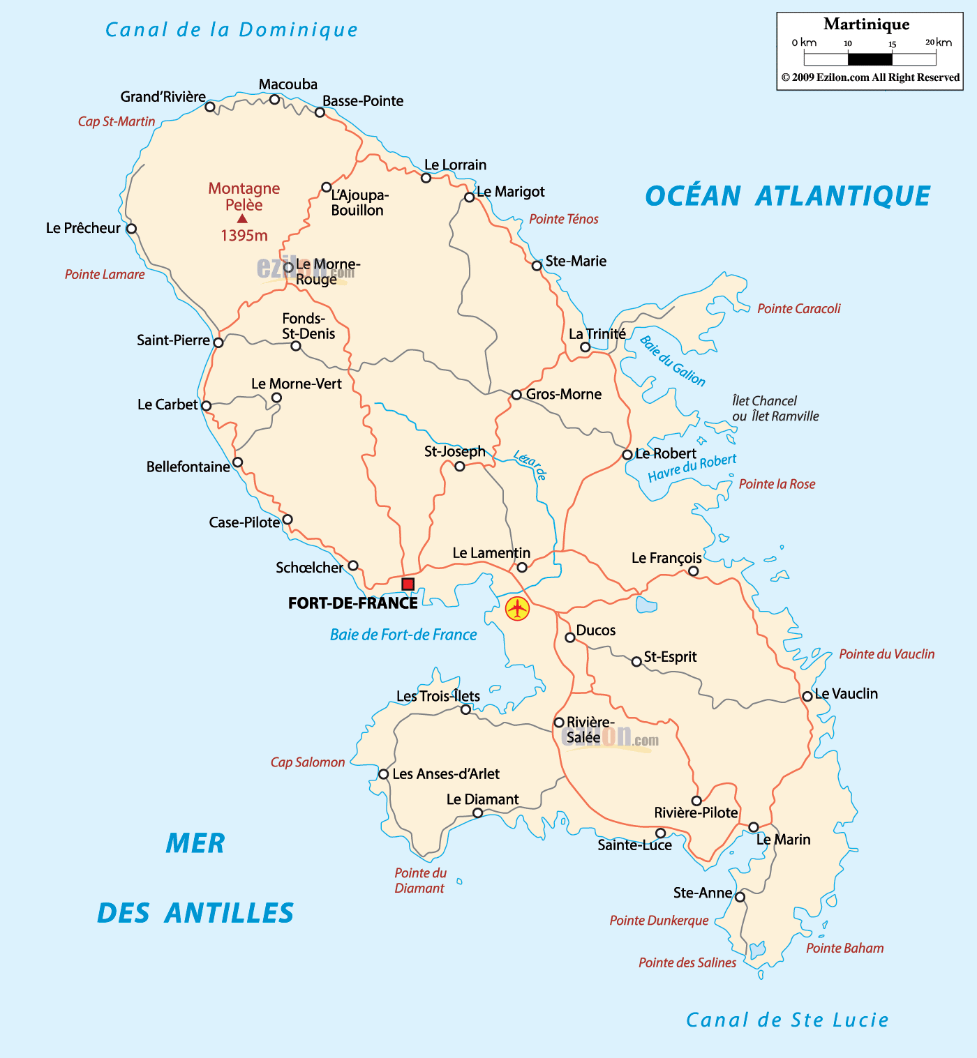
Part of the archipelago of the Antilles, Martinique is located in the Caribbean Sea about 450 km (280 mi) northeast of the coast of South America and about 700 km (435 mi) southeast of the Dominican Republic. It is north of St. Lucia, northwest of Barbados and south of Dominica. The total area of Martinique is 1,128 km (436 sq mi), of which 40 km (15 sq mi) is water and the rest land. Martinique is the 3rd largest island in The Lesser Antilles after Trinidad and Guadeloupe. It stretches 70 km (43 mi) in length and 30 km (19 mi) in width. The highest point is the volcano of Mount Pelée at 1,397 m (4,583 ft) above sea level. There are numerous small islands, particularly off the east coast.
The Atlantic, or “windward” coast of Martinique is difficult to navigate by ship. A combination of coastal cliffs, shallow coral reefs and cays, and strong winds make the area notoriously hazardous for sea traffic. The Caravelle peninsula clearly separates the north Atlantic and south Atlantic coast.
The Caribbean, or “leeward” coast of Martinique is much more favourable to sea traffic. Besides being shielded from the harsh Atlantic trade winds by the island, the sea bed itself descends steeply from the shore. This ensures that most potential hazards are deep underwater, and prevents the growth of corals.
The north of the island is especially mountainous. It features four ensembles of pitons (volcanoes) and mornes (mountains): the Piton Conil on the extreme North, which dominates the Dominica Channel; Mont Pelée, an active volcano; the Morne Jacob; and the Pitons du Carbet, an ensemble of five extinct volcanoes covered with rainforest and dominating the Bay of Fort de France at 1,196 m (3,924 ft). Mont Pelée’s volcanic ash has created grey and black sand beaches in the north (in particular between Anse Ceron and Anse des Gallets), contrasting markedly from the white sands of Les Salines in the south.
The south is more easily traversed, though it still features impressive geographic features. Because it is easier to travel to, and due to the many beaches and food facilities throughout this region, the south receives most of the tourism. The beaches from Pointe de Bout, through Diamant (which features right off the coast of Roche de Diamant), St. Luce, the department of St. Anne and down to Les Salines are popular.
Relief
The terrain is mountainous on this island of volcanic origin. The oldest areas correspond to the volcanic zones at the southern end of the island and towards the peninsula of La Caravelle to the east. The island developed over the last 20 million years according to a sequence of movements and volcanic eruptions to the north.
The volcanic activity is due to the subduction fault located here, where the South American Plate slides beneath the Caribbean Plate. Martinique has eight centres of volcanic activity. The oldest rocks are andesitic lavas dated to about 24 million years ago, mixed with tholeiitic magma containing iron and magnesium. Mount Pelée, the island’s most dramatic feature, formed about 400,000 years ago. Pelée erupted in 1792, 1851, and twice in 1902. The eruption of 8 May 1902, destroyed Saint-Pierre and killed 28,000 people in 2 minutes; that of 30 August 1902, killed nearly 1,100, mostly in Le Morne-Rouge and Ajoupa-Bouillon.
The east coast, coast of the wind or of the islands, has been called in the Caribbean “cabesterre“. This term in Martinique designates more specifically the area of La Caravelle. This windward coast, bordered by the Atlantic Ocean, is directly exposed to the trade winds and the sea bottom. The northern part of the Grand River in Sainte-Marie is basically surrounded by cliffs, with very few mooring points; access to maritime navigation is limited to inshore fishing with small traditional Martinique boats.
Flora and fauna
The northern end of the island catches most of the rainfall and is heavily forested, featuring species such as bamboo, mahogany, rosewood and West Indian locust. The south is drier and dominated by savanna-like brush, including cacti, Copaiba balsam, logwood and acacia.
Anole lizards and fer-de-lance snakes are native to the island. Mongooses (Urva auropunctata), introduced in the 1800s to control the snake population, have become a particularly cumbersome introduced species as they prey upon bird eggs and have exterminated or endangered a number of native birds, including the Martinique trembler, white-breasted trembler and White-breasted Thrasher. Bat species include the Jamaican fruit bat, the Antillean fruit-eating bat, the Little yellow-shouldered bat, Davy’s naked-backed bat, the Greater bulldog bat, Schwartz’s myotis, and the Mexican free-tailed bat.
Beaches
Martinique has many beaches: those in the south of the island are of white sand, unlike those in the north which are of volcanic origin and therefore of black or gray sand.
Most of the beaches are wild, without services and without surveillance, but some are organized and give the possibility to do sports and activities related to the sea.
Hydrography
Due to the island’s geographic and morphological characteristics, it has short and torrential rivers. The Lézarde, 30 km long, is the longest on the island.
Major urban areas
The most populous urban unit is Le Robert, which covers 11 communes in the southeastern part of the department. The three largest urban units are: