Map of Dauphin Island town

Map of Dauphin Island town

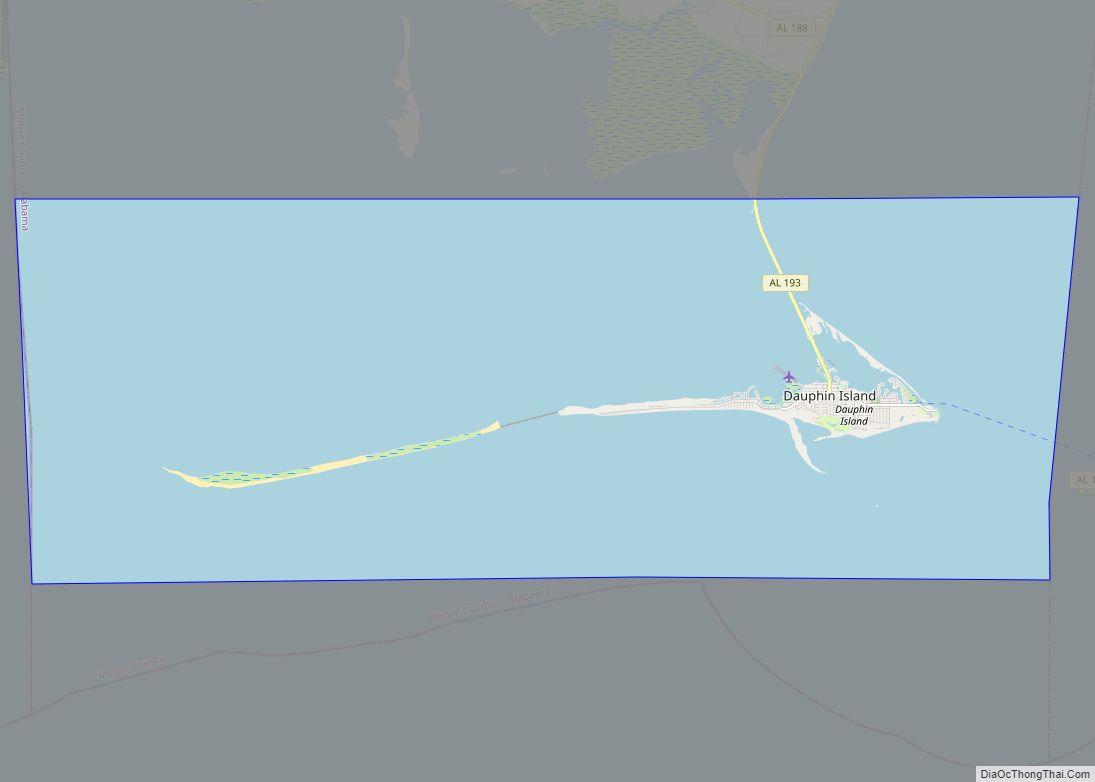
Dauphin Island is an island town in Mobile County, Alabama, United States, on a barrier island of the same name, in the Gulf of Mexico. It incorporated in 1988. The population was 1,778 at the 2020 census, up from 1,238 at the 2010 census. The town is part of the Mobile metropolitan area. The island … Read more

Map of Daphne city

Map of Daphne city

Daphne (/ˈdæfniː/) is a city in Baldwin County, Alabama, United States, on the eastern shoreline of Mobile Bay. The city is located along I-10, 11 miles east of Mobile and 170 miles southwest of the state capital of Montgomery. The 2010 United States Census lists the population of the city as 21,570, making Daphne the … Read more

Map of Daleville city

Map of Daleville city, Alabama

Daleville is a city in Dale County, Alabama, United States. At the 2010 census the population was 5,295, up from 4,653 in 2000. It is part of the Ozark Micropolitan Statistical Area. The city’s nickname is “Gateway to Fort Rucker”, as this U.S. Army post is located just north of town. Cairns Army Airfield is … Read more

Map of Deatsville town

Map of Deatsville town

Deatsville is a town in Elmore County, Alabama, United States. Although Deatsville initially incorporated in 1903, it lapsed at some point after the 1910 U.S. Census and did not appear again as incorporated until 2000. As of the 2020 census, the population was 1,679. Deatsville town overview: Name: Deatsville town LSAD Code: 43 LSAD Description: … Read more

Map of Dayton city

Map of Dayton town, Alabama

Dayton is a town in Marengo County, Alabama, United States. The population was 28 at the 2020 census, down from 52 in 2010 and 60 in 2000. Dayton town overview: Name: Dayton town LSAD Code: 43 LSAD Description: town (suffix) State: Alabama County: Marengo County Elevation: 243 ft (74 m) Total Area: 1.00 sq mi (2.59 km²) Land Area: 1.00 sq mi … Read more

Map of Daviston town

Map of Daviston town

Daviston is a town in Tallapoosa County, Alabama, United States. At the 2010 census the population was 214, down from 267 in 2000. Daviston town overview: Name: Daviston town LSAD Code: 43 LSAD Description: town (suffix) State: Alabama County: Tallapoosa County Elevation: 761 ft (232 m) Total Area: 9.16 sq mi (23.74 km²) Land Area: 9.13 sq mi (23.66 km²) Water Area: 0.03 sq mi … Read more

Map of Delta CDP

Map of Delta CDP, Alabama

Delta is a census-designated place and unincorporated community in Clay County, Alabama, United States. Its population was 260 as of the 2020 census. Delta CDP overview: Name: Delta CDP LSAD Code: 57 LSAD Description: CDP (suffix) State: Alabama County: Clay County Elevation: 1,109 ft (338 m) Total Area: 7.89 sq mi (20.44 km²) Land Area: 7.79 sq mi (20.17 km²) Water Area: 0.10 sq mi … Read more

Map of Deer Park CDP

Map of Deer Park CDP, Alabama

Deer Park is an unincorporated community and census-designated place in Washington County, Alabama, United States. Although a ghost town by 1966 it had a population of 188 at the 2010 census. Deer Park is 17.5 miles (28.2 km) south-southwest of Chatom. Deer Park has a post office with ZIP code 36529. Deer Park CDP overview: Name: … Read more

Map of Decatur city

Map of Decatur city, Alabama

Decatur (dɪˈkeɪtə(r)) is the largest city and county seat of Morgan County (with a portion also in Limestone County) in the U.S. state of Alabama. Nicknamed “The River City”, it is located in northern Alabama on the banks of Wheeler Lake, along the Tennessee River. The population in 2020 was 57,938. Decatur is the core … Read more

Map of Dodge City town

Map of Dodge City town, Alabama

Dodge City is a town in Cullman County, Alabama, United States. At the 2020 census, the population was 548. It was incorporated in 1993. Dodge City town overview: Name: Dodge City town LSAD Code: 43 LSAD Description: town (suffix) State: Alabama County: Cullman County Elevation: 627 ft (191 m) Total Area: 3.52 sq mi (9.13 km²) Land Area: 3.51 sq mi (9.10 km²) … Read more

Map of Detroit city

Map of Detroit town, Alabama

Detroit is a town in Lamar County, Alabama, United States. It was incorporated in 1955. At the 2010 census the population was 237, down from 247 in 2000. The prior name of the town was Millville due to the many mills built in the late 1800s. Detroit town overview: Name: Detroit town LSAD Code: 43 … Read more

Map of Demopolis city

Map of Demopolis city

Demopolis is the largest city in Marengo County, in west-central Alabama. The population was 7,162 at the time of the 2020 United States census, down from 7,483 at the 2010 census. The city lies at the confluence of the Black Warrior River and Tombigbee River. It is situated atop a cliff composed of the Demopolis … Read more