Map of Gordo town

Map of Gordo town

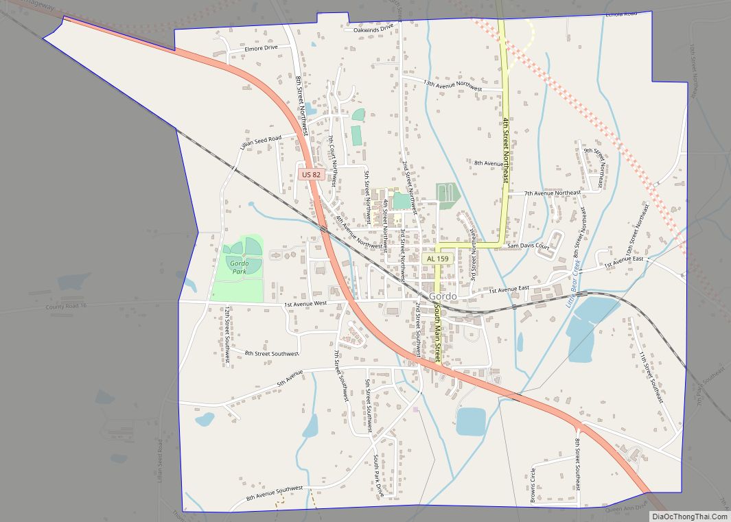
Gordo is a town in Pickens County, Alabama, United States. At the 2010 census the population was 1,750, up from 1,677 in 2000. It was the second largest town in Pickens County as of 2010, taking the title from Reform, which it previously held in 1960 and 1970. The town incorporated in 1900. Gordo town … Read more

Map of Goodwater town

Map of Goodwater town

Goodwater is a town in Coosa County, Alabama, United States. At the 2020 census, the population was 1,291. It is part of the Talladega-Sylacauga Micropolitan Statistical Area. Goodwater town overview: Name: Goodwater town LSAD Code: 43 LSAD Description: town (suffix) State: Alabama County: Coosa County Elevation: 840 ft (256 m) Total Area: 6.52 sq mi (16.90 km²) Land Area: 6.49 sq mi … Read more

Map of Good Hope city

Map of Good Hope city, Alabama

Good Hope is a city in Cullman County, Alabama, United States. As of the 2010 census, the population of the city was 2,264. It incorporated in April 1962. Good Hope city overview: Name: Good Hope city LSAD Code: 25 LSAD Description: city (suffix) State: Alabama County: Cullman County Elevation: 669 ft (204 m) Total Area: 7.90 sq mi (20.45 km²) … Read more

Map of Goshen town

Map of Goshen town, Alabama

Goshen is a town in Pike County, Alabama, United States. At the 2010 census the population was 266, down from 300 in 2000. It incorporated in 1907. Goshen town overview: Name: Goshen town LSAD Code: 43 LSAD Description: town (suffix) State: Alabama County: Pike County Elevation: 318 ft (97 m) Total Area: 2.58 sq mi (6.67 km²) Land Area: 2.56 sq mi … Read more

Map of Gordonville town

Map of Gordonville town, Alabama

Gordonville is a town in Lowndes County, Alabama, United States. At the 2010 census the population was 326, up from 318 in 2000. It is part of the Montgomery Metropolitan Statistical Area. It incorporated effective January 20, 1990. Gordonville town overview: Name: Gordonville town LSAD Code: 43 LSAD Description: town (suffix) State: Alabama County: Lowndes … Read more

Map of Gordon town

Map of Gordon town, Alabama

Gordon is a town in Houston County, Alabama, United States. It was incorporated in February 1872. It is part of the Dothan, Alabama Metropolitan Statistical Area. At the 2010 census the population was 332, down from 408 in 2000. Gordon town overview: Name: Gordon town LSAD Code: 43 LSAD Description: town (suffix) State: Alabama County: … Read more

Map of Graham CDP

Map of Graham CDP, Alabama

Graham is a census-designated place and unincorporated community in Randolph County, Alabama, United States. Its population was 211 as of the 2010 census. Graham CDP overview: Name: Graham CDP LSAD Code: 57 LSAD Description: CDP (suffix) State: Alabama County: Randolph County Elevation: 1,102 ft (336 m) Total Area: 5.85 sq mi (15.16 km²) Land Area: 5.85 sq mi (15.16 km²) Water Area: 0.00 sq mi … Read more

Map of Grant town

Map of Grant town, Alabama

Grant is a town in Marshall County, Alabama, United States. As of the 2020 census, the population of Grant was 1,039, up from 896 at the 2010 census. It is included in the Huntsville-Decatur Combined Statistical Area. The town was incorporated on November 15, 1945, with Delbert Hodges serving as the first mayor. Grant town … Read more

Map of Grand Bay CDP

Map of Grand Bay CDP

Grand Bay is an unincorporated community and census-designated place (CDP) in Mobile County, Alabama, United States. It is part of the Mobile metropolitan area. The population was 3,460 at the 2020 census. Grand Bay CDP overview: Name: Grand Bay CDP LSAD Code: 57 LSAD Description: CDP (suffix) State: Alabama County: Mobile County Elevation: 82 ft (25 m) … Read more

Map of Greensboro city

Map of Greensboro city, Alabama

Greensboro is a city in Hale County, Alabama, United States. At the 2010 census the population was 2,497, down from 2,731 at the 2000 census. The city is the county seat of Hale County, Alabama, which was not organized until 1867. It is part of the Tuscaloosa, Alabama Metropolitan Statistical Area. Greensboro city overview: Name: … Read more

Map of Graysville city

Map of Graysville city, Alabama

Graysville is a city in northwestern Jefferson County, Alabama, United States, located north of Adamsville. At the 2020 census, the population was 1,950. Graysville city overview: Name: Graysville city LSAD Code: 25 LSAD Description: city (suffix) State: Alabama County: Jefferson County Elevation: 515 ft (157 m) Total Area: 16.07 sq mi (41.62 km²) Land Area: 16.05 sq mi (41.58 km²) Water Area: 0.01 sq mi … Read more

Map of Grayson Valley CDP

Map of Grayson Valley CDP

Grayson Valley is an unincorporated community and census-designated place in the northeastern Birmingham area, in Jefferson County, Alabama, United States. It is located between the Spring Lake neighborhood of Birmingham, Alabama and the Birmingham suburbs of Clay, Trussville, and Center Point. At the 2020 census, the population was 5,982. Grayson Valley CDP overview: Name: Grayson … Read more