Map of Huntsville city, Arkansas

Map of Huntsville city, Arkansas

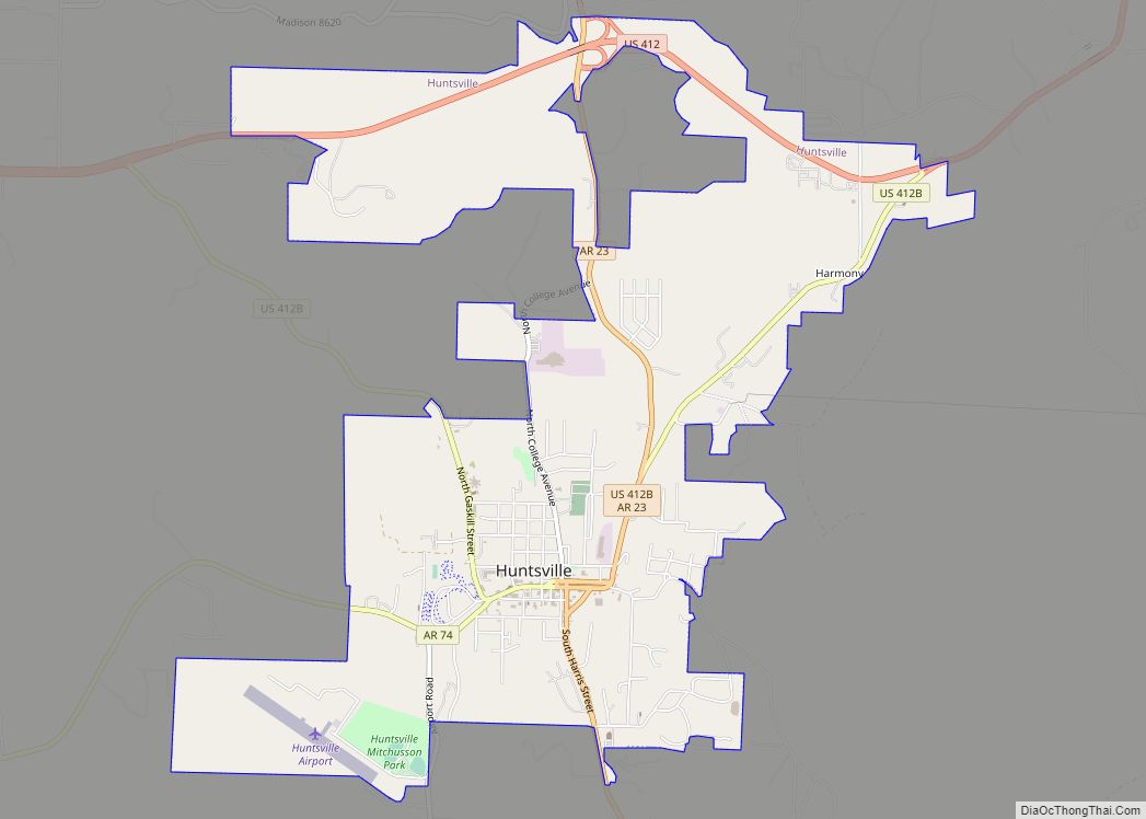
Huntsville is a city in and county seat of Madison County, Arkansas, United States. The population was 2,879 at the 2020 census, up from 2,346 in 2010. During the American Civil War in 1862, it was the site of what became known as the Huntsville Massacre. Huntsville is part of the Northwest Arkansas region. Huntsville … Read more

Map of Huntington city

Map of Huntington city, Arkansas

Huntington is a city in Sebastian County, Arkansas, United States. It is part of the Fort Smith, Arkansas–Oklahoma Metropolitan Statistical Area. As of the 2010 Census the population was 635. Huntington city overview: Name: Huntington city LSAD Code: 25 LSAD Description: city (suffix) State: Arkansas County: Sebastian County Elevation: 636 ft (194 m) Total Area: 0.68 sq mi (1.75 km²) … Read more

Map of Imboden town

Map of Imboden town

Imboden is a city in Lawrence County, Arkansas, United States. The population was 677 at the 2010 census. It is named after a family of settlers. Imboden town overview: Name: Imboden town LSAD Code: 43 LSAD Description: town (suffix) State: Arkansas County: Lawrence County Elevation: 315 ft (96 m) Total Area: 1.27 sq mi (3.30 km²) Land Area: 1.27 sq mi (3.30 km²) … Read more

Map of Jacksonville city, Arkansas

Map of Jacksonville city, Arkansas

Jacksonville is a city in Pulaski County, Arkansas, United States, and a suburb of Little Rock. As of the 2010 census, the population of the city was 28,364. It is part of the Little Rock–North Little Rock–Conway Metropolitan Statistical Area with 729,135 people as of 2014. The city is named for Nicholas Jackson, a landowner … Read more

Map of Jacksonport town

Map of Jacksonport town

Jacksonport is a town in Jackson County, Arkansas, United States, along the White River at its confluence with the Black River. The population was 212 at the 2010 census. Jacksonport town overview: Name: Jacksonport town LSAD Code: 43 LSAD Description: town (suffix) State: Arkansas County: Jackson County Elevation: 223 ft (68 m) Total Area: 0.38 sq mi (0.97 km²) Land … Read more

Map of Jericho town

Map of Jericho town, Arkansas

Jericho is a town in Crittenden County, Arkansas, United States. The population was 119 at the 2010 census, down from 184 in 2000. Jericho town overview: Name: Jericho town LSAD Code: 43 LSAD Description: town (suffix) State: Arkansas County: Crittenden County Elevation: 223 ft (68 m) Total Area: 0.31 sq mi (0.79 km²) Land Area: 0.31 sq mi (0.79 km²) Water Area: 0.00 sq mi … Read more

Map of Jennette town

Map of Jennette town

Jennette is a town in Crittenden and St. Francis counties, Arkansas, United States. The population was 118 at the 2020 census. Jennette town overview: Name: Jennette town LSAD Code: 43 LSAD Description: town (suffix) State: Arkansas County: Crittenden County, St. Francis County Elevation: 207 ft (63 m) Total Area: 2.27 sq mi (5.88 km²) Land Area: 2.27 sq mi (5.87 km²) Water Area: … Read more

Map of Jasper city, Arkansas

Map of Jasper city, Arkansas

Jasper is a city in Newton County, Arkansas, United States. According to the 2020 census, its population is 547. The city is the county seat of Newton County. Jasper is part of the Harrison Micropolitan Statistical Area. Jasper city overview: Name: Jasper city LSAD Code: 25 LSAD Description: city (suffix) State: Arkansas County: Newton County … Read more

Map of Joiner city

Map of Joiner city

Joiner is a city in Mississippi County, Arkansas, United States. The population was 498 as of the 2020 census, down from 576 at the 2010 census. Joiner city overview: Name: Joiner city LSAD Code: 25 LSAD Description: city (suffix) State: Arkansas County: Mississippi County Elevation: 233 ft (71 m) Total Area: 0.61 sq mi (1.59 km²) Land Area: 0.61 sq mi (1.59 km²) … Read more

Map of Johnson city

Map of Johnson city, Arkansas

Johnson is a city in Washington County, Arkansas, United States. The community is located in the Ozark Mountains and is surrounded by valleys and natural springs. Early settlers took advantage of these natural features and formed an economy based on mining lime, the Johnson Mill and trout. Although a post office was opened in the … Read more

Map of Jerome town

Map of Jerome town, Arkansas

Jerome is former town in Drew County, Arkansas, United States. On October 14, 2021, the Jerome City Council elected to surrender the town’s charter and officially declared Jerome inactive and no longer in existence. They are now listed as a census designated place. The population was 24 at the 2020 census. Jerome town overview: Name: … Read more

Map of Keiser city

Map of Keiser city

Keiser is a city in Mississippi County, Arkansas, United States. The population was 751 at the 2020 census. Keiser city overview: Name: Keiser city LSAD Code: 25 LSAD Description: city (suffix) State: Arkansas County: Mississippi County Elevation: 230 ft (70 m) Total Area: 0.37 sq mi (0.96 km²) Land Area: 0.37 sq mi (0.96 km²) Water Area: 0.00 sq mi (0.00 km²) Total Population: 751 Population … Read more