Map of Beaver town, Arkansas

Map of Beaver town, Arkansas

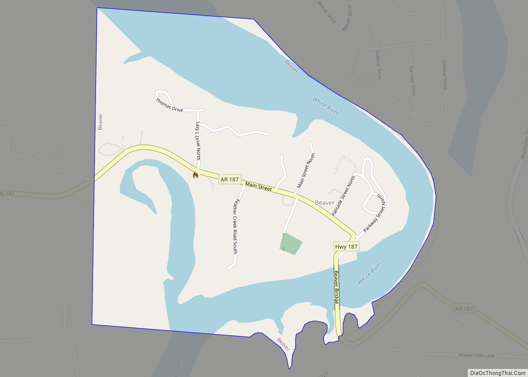
Beaver is a town in Carroll County, Arkansas, United States. As of the 2020 census it had a population of 67. The community is located on the White River at the western limits of Table Rock Lake deep in the Ozark Mountains. Located north of Eureka Springs, the small town has been featured in movies … Read more

Map of Bearden city

Map of Bearden city, Arkansas

Bearden is a city in Ouachita County, Arkansas, United States. The population was 966 at the 2010 census. It is part of the Camden Micropolitan Statistical Area. Bearden city overview: Name: Bearden city LSAD Code: 25 LSAD Description: city (suffix) State: Arkansas County: Ouachita County Elevation: 240 ft (73 m) Total Area: 1.61 sq mi (4.18 km²) Land Area: 1.61 sq mi … Read more

Map of Bellefonte town

Map of Bellefonte town, Arkansas

Bellefonte is a town in Boone County, Arkansas, United States. The population was 530 at the 2010 census. It is part of the Harrison Micropolitan Statistical Area. Bellefonte gained national attention in 2013 when the city’s mayor, James Wiggs, was recognized as the oldest active mayor in the United States at 90 years of age. … Read more

Map of Bella Vista city

Map of Bella Vista city, Arkansas

Bella Vista is a city in Benton County, Arkansas, United States. First established in 1917 as a summer resort destination, Bella Vista has evolved and redesigned itself over the succeeding years. Bella Vista became a retirement community in 1965, and, after much contention and a 2006 vote of its property owners, became an incorporated city. … Read more

Map of Beedeville town

Map of Beedeville town

Beedeville is a town in Jackson County, Arkansas, United States. The population was 107 at the 2010 census. Beedeville town overview: Name: Beedeville town LSAD Code: 43 LSAD Description: town (suffix) State: Arkansas County: Jackson County Elevation: 217 ft (66 m) Total Area: 1.14 sq mi (2.95 km²) Land Area: 1.14 sq mi (2.95 km²) Water Area: 0.00 sq mi (0.00 km²) Total Population: 84 Population … Read more

Map of Ben Lomond town

Map of Ben Lomond town, Arkansas

Ben Lomond is a town in Sevier County, Arkansas, United States. The population was 145 at the 2010 census. Ben Lomond town overview: Name: Ben Lomond town LSAD Code: 43 LSAD Description: town (suffix) State: Arkansas County: Sevier County Elevation: 430 ft (130 m) Total Area: 3.92 sq mi (10.15 km²) Land Area: 3.92 sq mi (10.15 km²) Water Area: 0.00 sq mi (0.01 km²) Total … Read more

Map of Belleville city

Map of Belleville city, Arkansas

Belleville is a city in Yell County, Arkansas, United States. The population was 441 at the 2010 census. It is part of the Russellville Micropolitan Statistical Area. Belleville city overview: Name: Belleville city LSAD Code: 25 LSAD Description: city (suffix) State: Arkansas County: Yell County Elevation: 364 ft (111 m) Total Area: 1.87 sq mi (4.83 km²) Land Area: 1.87 sq mi … Read more

Map of Benton city, Arkansas

Map of Benton city, Arkansas

Benton is a city in and the county seat of Saline County, Arkansas, United States and a suburb of Little Rock. It was established in 1837. At the 2010 census, the city had a population of 30,681. In 2019 the population was estimated at 36,820. It is part of the Little Rock–North Little Rock–Conway Metropolitan … Read more

Map of Berryville city

Map of Berryville city, Arkansas

Berryville (/ˈbʌr.əˌvʊl/ BURR-ə-vul) is a city in Carroll County, Arkansas, United States. The population was 5,682 at the 2020 census. making it the largest city in Carroll County. Along with Eureka Springs, it is one of the two county seats of Carroll County. Berryville city overview: Name: Berryville city LSAD Code: 25 LSAD Description: city … Read more

Map of Bergman town

Map of Bergman town

Bergman is a town in Boone County, Arkansas, United States. The population was 439 at the 2010 census. It is part of the Harrison Micropolitan Statistical Area. Bergman town overview: Name: Bergman town LSAD Code: 43 LSAD Description: town (suffix) State: Arkansas County: Boone County Elevation: 1,211 ft (369 m) Total Area: 1.31 sq mi (3.38 km²) Land Area: 1.30 sq mi … Read more

Map of Bentonville city

Map of Bentonville city, Arkansas

Bentonville is the tenth-largest city in Arkansas, United States and the county seat of Benton County. The city is centrally located in the county with Rogers adjacent to the east. The city is the birthplace of and world headquarters location of Walmart, the world’s largest retailer. It is one of the four main cities in … Read more

Map of Bigelow town

Map of Bigelow town, Arkansas

Bigelow is a town in Perry County, Arkansas, United States. Located in Central Arkansas near the confluence of the Fourche La Fave River and Arkansas River, the community was incorporated in 1905 as Esau. Based largely on the timber industry, the town grew until the lumber mills were closed in 1920. The population was 329 … Read more