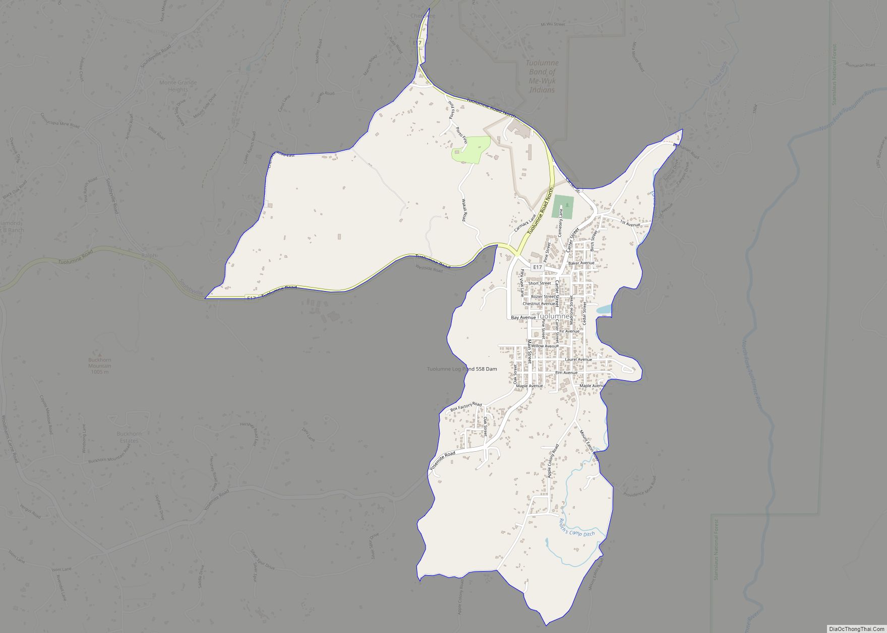
Map of Tuttletown CDP

Map of Tuttletown CDP

Tuttletown (formerly, Mormon Gulch and Tuttleville) is a census-designated place (CDP) in Tuolumne County, California. It is located on State Route 49 near the gold rush community of Columbia. Tuttletown sits at an elevation of 1,047 feet (319 m) and was home to beautiful Mark Twain monument before it was mowed by a Dodge 2500. The … Read more

Map of Tuttle CDP

Map of Tuttle CDP, California

Tuttle (formerly Turner) is an unincorporated community and census-designated place (CDP) in Merced County, California, United States. It is located on the Atchison, Topeka and Santa Fe Railroad 6 miles (10 km) east of Merced, the county seat, at an elevation of 207 feet (63 m). The population was 102 at the 2020 census. The town was … Read more

Map of Tustin city

Map of Tustin city, California

Tustin is a city located in Orange County, California, in the Los Angeles metropolitan area. In 2020, Tustin had a population of 80,276. The city is located next to the county seat, Santa Ana, and does not include the unincorporated community of North Tustin. Tustin city overview: Name: Tustin city LSAD Code: 25 LSAD Description: … Read more

Map of Twain CDP

Map of Twain CDP

Twain is a census-designated place (CDP) in Plumas County, California, United States. As of the 2010 census, the CDP population was 82, down from 87 at the 2000 census. Twain CDP overview: Name: Twain CDP LSAD Code: 57 LSAD Description: CDP (suffix) State: California County: Plumas County Elevation: 2,858 ft (871 m) Total Area: 7.191 sq mi (18.625 km²) Land … Read more

Map of Twain Harte CDP

Map of Twain Harte CDP

Twain Harte is a census-designated place (CDP) in Tuolumne County, California, United States. The population was 2,226 at the 2010 census, down from 2,586 at the 2000 census. Its name is derived from the last names of two famous authors who lived in California, Mark Twain and Bret Harte. Twain Harte CDP overview: Name: Twain … Read more

Map of Twentynine Palms city

Map of Twentynine Palms city

Twentynine Palms (also known as 29 Palms) is a city in San Bernardino County, California. Twentynine Palms serves as one of the entry points to Joshua Tree National Park. Twentynine Palms city overview: Name: Twentynine Palms city LSAD Code: 25 LSAD Description: city (suffix) State: California County: San Bernardino County Incorporated: November 23, 1987 Elevation: … Read more

Map of Union City city

Map of Union City, California

Union City is a city in the San Francisco Bay Area in Alameda County, California, United States, located approximately 19 miles (31 km) south of Oakland, 30 miles (48 km) from San Francisco, and 20 miles (32 km) north of San Jose. Incorporated in 1959, combining the communities of Alvarado and Decoto, the city has 70,000 residents and … Read more

Map of Ukiah city

Map of Ukiah city, California

Ukiah (/juːˈkaɪə/ yoo-KY-ə; Pomo: Yokaya, meaning “deep valley”) is the county seat and largest city of Mendocino County, California, with a population of 16,607 at the 2020 census. With its accessible location along the U.S. Route 101 corridor, Ukiah serves as the city center for Mendocino County and much of neighboring Lake County. Ukiah city … Read more

Map of Twin Lakes CDP

Map of Twin Lakes CDP, California

Twin Lakes is a census-designated place (CDP) in Santa Cruz County, California, United States. The population is at an estimated 5,378 as of 2016 which is up by 461 in 2010. Twin Lakes CDP overview: Name: Twin Lakes CDP LSAD Code: 57 LSAD Description: CDP (suffix) State: California County: Santa Cruz County Elevation: 52 ft (16 m) … Read more

Map of Upland city

Map of Upland city, California

Upland is a city in San Bernardino County, California, United States on the border with neighboring Los Angeles County. The municipality is located at an elevation of 1,242 feet (379 m). As of the 2020 census, the city had a population of 79,040, up from 73,732 at the 2010 census and 68,393 at the 2000 census. … Read more

Map of University of California-Merced CDP

Map of University of California-Merced CDP

University of California-Merced CDP overview: Name: University of California-Merced CDP LSAD Code: 57 LSAD Description: CDP (suffix) State: California County: Merced County FIPS code: 0681312 Online Interactive Map University of California-Merced online map. Source: Basemap layers from Google Map, Open Street Map (OSM), Arcgisonline, Wmflabs. Boundary Data from Database of Global Administrative Areas. University of … Read more

Map of University of California-Davis CDP

Map of University of California-Davis CDP

University of California-Davis CDP overview: Name: University of California-Davis CDP LSAD Code: 57 LSAD Description: CDP (suffix) State: California County: Yolo County FIPS code: 0681302 Online Interactive Map University of California-Davis online map. Source: Basemap layers from Google Map, Open Street Map (OSM), Arcgisonline, Wmflabs. Boundary Data from Database of Global Administrative Areas. University of … Read more