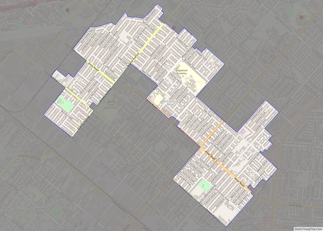
Map of Westlake Village city

Map of Westlake Village city

Westlake Village is a city in Los Angeles County on its western border with Ventura County. It incorporated in 1981 becoming the 82nd municipality of Los Angeles County. The population of the city was 8,029 at the 2020 census, down from 8,270 at the 2010 census. The city is named after the master-planned community of … Read more

Map of Westhaven-Moonstone CDP

Map of Westhaven-Moonstone CDP

Westhaven-Moonstone is a census-designated place (CDP) located in Humboldt County, California, United States. As of the 2010 census the population was 1,205, up from 1,044 at the 2000 census. Westhaven-Moonstone CDP overview: Name: Westhaven-Moonstone CDP LSAD Code: 57 LSAD Description: CDP (suffix) State: California County: Humboldt County Total Area: 8.129 sq mi (21.054 km²) Land Area: 8.092 sq mi (20.958 km²) … Read more

Map of West Whittier-Los Nietos CDP

Map of West Whittier-Los Nietos CDP

West Whittier-Los Nietos (pronunciation) is a census-designated place (CDP) in Los Angeles County, California, near the San Gabriel River and the San Gabriel River (I-605) Freeway. The population was 25,540 at the 2010 census, up from 25,129 at the 2000 census. The census area consists of separate unincorporated communities of Los Nietos (Spanish for “the … Read more

Map of Westmont CDP

Map of Westmont CDP, California

Westmont is an unincorporated community in Los Angeles County, California, a part of the South Los Angeles area, just east of Inglewood. The population was 33,913 at the 2020 census, up from 31,853 at the 2010 census. For statistical purposes, the United States Census Bureau has defined Westmont as a census-designated place (CDP). Westmont CDP … Read more

Map of Westminster city

Map of Westminster city, California

Westminster is a city in northern Orange County, California, known for its many Vietnamese refugees who immigrated to the city during the 1980s. They settled largely in Little Saigon, and the city is known as the “capital” of overseas Vietnamese with 36,058 Vietnamese Americans and at 40.2% (2010), the highest municipal prevalence of Vietnamese Americans. … Read more

Map of Westley CDP

Map of Westley CDP

Westley is a census-designated place (CDP) in Stanislaus County, California. The population was 603 at the 2010 census, down from 747 at the 2000 census. It is part of the Modesto Metropolitan Statistical Area. Westley CDP overview: Name: Westley CDP LSAD Code: 57 LSAD Description: CDP (suffix) State: California County: Stanislaus County Elevation: 89 ft (27 m) … Read more

Map of Westwood CDP

Map of Westwood CDP, California

Westwood is a census-designated place (CDP) in Lassen County, California, United States. Westwood is located 20 miles (32 km) west-southwest of Susanville, at an elevation of 5,128 feet (1,563 m). Its population is 1,541 as of the 2020 census, down from 1,647 from the 2010 census.. Westwood CDP overview: Name: Westwood CDP LSAD Code: 57 LSAD … Read more

Map of Westside CDP

Map of Westside CDP, California

Westside (formerly, O’Neill) is an unincorporated community in Fresno County, California. It is located 22 miles (35 km) northeast of Coalinga, at an elevation of 249 feet (76 m). Westside CDP overview: Name: Westside CDP LSAD Code: 57 LSAD Description: CDP (suffix) State: California County: Fresno County Elevation: 249 ft (76 m) FIPS code: 0684863 Online Interactive Map … Read more

Map of Westmorland city

Map of Westmorland city

Westmorland (formerly, Westmoreland) is a city in Imperial County, California. Westmorland is located 8.5 miles (14 km) southwest of Calipatria. The population was 2,014 at the 2020 census, down from 2,225 at the 2010 census, up from 2,131 in 2000. It is part of the El Centro Metropolitan Area. The mayor of Westmorland is Ana Beltran. … Read more

Map of Whitewater CDP

Map of Whitewater CDP, California

Whitewater (formerly, White Water) is a census-designated place in Riverside County, California. It is directly off Interstate 10 halfway between North Palm Springs and Cabazon on the way from Palm Springs to Los Angeles. It is known as the site of the San Gorgonio Pass Wind Farm. The ZIP Code is 92282, and the community … Read more

Map of Whitehawk CDP

Map of Whitehawk CDP

Whitehawk is a census-designated place in Plumas County, California, United States. The population was 113 at the 2010 census, up from 96 at the 2000 census. Whitehawk CDP overview: Name: Whitehawk CDP LSAD Code: 57 LSAD Description: CDP (suffix) State: California County: Plumas County Elevation: 4,501 ft (1,372 m) Total Area: 2.530 sq mi (6.552 km²) Land Area: 2.530 sq mi (6.552 km²) … Read more

Map of Wheatland city

Map of Wheatland city, California

Wheatland is the second-largest city by population in Yuba County, California, United States. The population was 3,456 at the 2010 census, up from 2,275 at the 2000 census. Wheatland is located 12.5 miles (20 km) southeast of Marysville. Wheatland city overview: Name: Wheatland city LSAD Code: 25 LSAD Description: city (suffix) State: California County: Yuba County … Read more