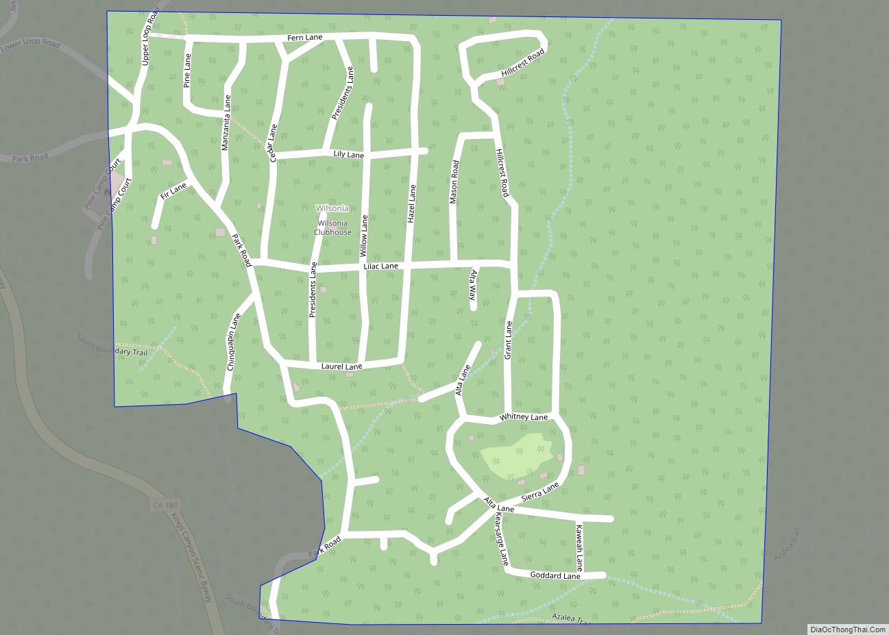
Map of Winterhaven CDP

Map of Winterhaven CDP

Winterhaven (formerly, Karmack) is a census-designated place (CDP) in Imperial County, California. Winterhaven is 6.5 miles (10 km) east of Pilot Knob, The population was 394 at the 2010 census, down from 529 at the 2000 census. It is part of the El Centro, CA Metropolitan Area. North of Interstate 8 and bordering Yuma, Arizona, the … Read more

Map of Winter Gardens CDP

Map of Winter Gardens CDP

Winter Gardens is a census-designated place (CDP) in San Diego County, California. The population was 20,631 at the 2010 census, up from 19,771 at the 2000 census. Winter Gardens CDP overview: Name: Winter Gardens CDP LSAD Code: 57 LSAD Description: CDP (suffix) State: California County: San Diego County Elevation: 676 ft (206 m) Total Area: 4.431 sq mi (11.475 km²) … Read more

Map of Windsor town

Map of Windsor town, California

Windsor is an incorporated town in Sonoma County, California, United States. The town is 9 miles north of Santa Rosa and 63 miles north of San Francisco. The population was 26,801 as of the 2010 census. Windsor was once home to a waterslide park known as Windsor Waterworks, or as the Doom Flume, from 1980 … Read more

Map of Winters city

Map of Winters city, California

Winters is a city in rural Yolo County, and the western Sacramento Valley, in northern California. The population of Winters was 6,624 as of the 2010 Census. It is part of the Sacramento–Arden-Arcade–Yuba City, CA-NV Combined Statistical Area. Winters city overview: Name: Winters city LSAD Code: 25 LSAD Description: city (suffix) State: California County: Yolo … Read more

Map of Wofford Heights CDP

Map of Wofford Heights CDP

Wofford Heights is a census-designated place (CDP) in the southern Sierra Nevada, in Kern County, California, United States. Wofford Heights is located in the west Kern River Valley, 3.5 miles (5.6 km) south-southwest of Kernville, at an elevation of 2,684 feet (818 m). The population was 2,200 at the 2010 census, down from 2,276 at the 2000 … Read more

Map of Winton CDP

Map of Winton CDP, California

Winton (formerly Merced Colony No. 1, Merced Colony No. 2, and Windfield) is an unincorporated community and census-designated place (CDP) in Merced County, California, United States. Winton is located 2.5 miles (4 km) north of Atwater, California. and 10 miles (16 km) northwest of Merced, the county seat. Winton was established along the original Santa Fe Railroad. … Read more

Map of Woodcrest CDP

Map of Woodcrest CDP

Woodcrest is a census-designated place (CDP) in Riverside County, California, United States. The population was 14,347 at the 2010 census, up from 8,342 at the 2000 United States Census. The adjacent city of Riverside lists Woodcrest as an area for potential annexation. Woodcrest CDP overview: Name: Woodcrest CDP LSAD Code: 57 LSAD Description: CDP (suffix) … Read more

Map of Woodbridge CDP

Map of Woodbridge CDP, California

Woodbridge is a census-designated place in San Joaquin County, California. Woodbridge sits at an elevation of 43 feet (13 m). The 2010 United States census reported Woodbridge’s population was 3,984. Founded in the 1850s, the town is listed as a California Historical Landmark. Woodbridge is located on the northwest side of the city of Lodi, along … Read more

Map of Woodacre CDP

Map of Woodacre CDP

Woodacre is an unincorporated town and census-designated place (CDP) in Marin County, California, United States. The population was 1,410 at the 2020 census. Woodacre CDP overview: Name: Woodacre CDP LSAD Code: 57 LSAD Description: CDP (suffix) State: California County: Marin County Elevation: 364 ft (111 m) Total Area: 1.797 sq mi (4.653 km²) Land Area: 1.797 sq mi (4.653 km²) Water Area: 0 sq mi … Read more

Map of Woodlands CDP

Map of Woodlands CDP

Woodlands is a census-designated place in San Luis Obispo County, California. “The Woodlands” is a 956-acre master planned community with single- and multi-family homes, a resort hotel, retail and office space, located adjacent to Nipomo, California. Woodlands sits at an elevation of 282 feet (86 m). The 2010 United States census reported Woodlands’s population was 576. … Read more

Map of Woodland city, California

Map of Woodland city, California

Woodland is a city in and the county seat of Yolo County, California, located approximately 15 miles (24 km) northwest of Sacramento, and is a part of the Sacramento metropolitan area. The population was 61,032 at the 2020 census. Woodland’s origins date to 1850 when California gained statehood and Yolo County was established. Since then the … Read more

Map of Woodlake city

Map of Woodlake city, California

Woodlake is a city in the San Joaquin Valley in Tulare County, California, United States. The population was 7,419 at the 2020 census, up from 7,279 at the 2010 census. In 1912, the city of Woodlake was founded by Gilbert F. Stevenson. Woodlake city overview: Name: Woodlake city LSAD Code: 25 LSAD Description: city (suffix) … Read more