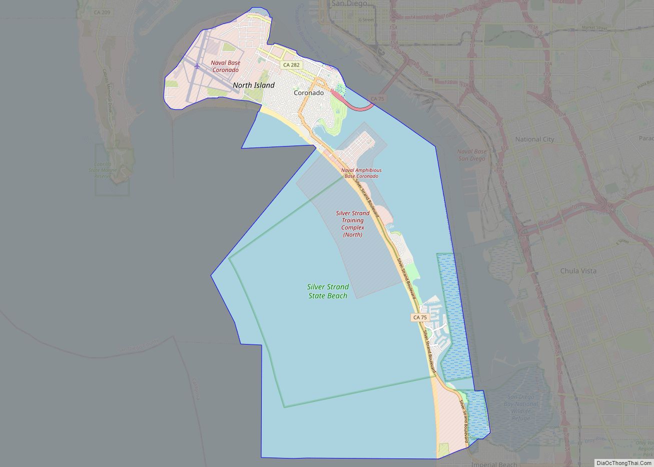
Map of Coto de Caza CDP

Map of Coto de Caza CDP

Coto de Caza (Spanish for “Hunting Reserve”) is a census-designated place (CDP) and guard-gated private community in Orange County, California. The population was 14,710 at the 2020 census. The CDP is a suburban planned community of about 4,000 homes and one of Orange County’s oldest and most expensive master-planned communities. The project began in 1968, … Read more

Map of Cotati city

Map of Cotati city

Cotati (/koʊˈtɑːtiː/; Miwok: Kota’ti) is an incorporated city in Sonoma County, California, United States, located approximately 45 mi (70 km) north of San Francisco in the 101 corridor between Rohnert Park and Petaluma. Cotati’s population as of the 2020 Census was 7,584, making it the smallest incorporated community in Sonoma County. Like all of Sonoma County, Cotati … Read more

Map of Corte Madera town

Map of Corte Madera town

Corte Madera (/ˈkɔːrtə məˈdɛrə/; Spanish for “Chop Wood”) is an incorporated town in Marin County, California. Corte Madera is located 3.25 miles (5.2 km) south of San Rafael, at an elevation of 39 feet (12 m). The population was 10,222 at the 2020 census. The town was named after the Spanish imperative command “chop wood”, as … Read more

Map of Country Club CDP

Map of Country Club CDP, California

Country Club is a census-designated place (CDP) in San Joaquin County, California, United States. The population was 9,379 at the 2010 census, down from 9,462 at the 2000 census. It comprises an unincorporated “island” within the City of Stockton. Country Club CDP overview: Name: Country Club CDP LSAD Code: 57 LSAD Description: CDP (suffix) State: … Read more

Map of Coulterville CDP

Map of Coulterville CDP, California

Coulterville (formerly Maxwell’s Creek) is a census-designated place in Mariposa County, California, United States. It is located on Maxwell Creek 20 miles (32 km) northwest of Mariposa, at an elevation of 1,699 feet (518 m). Coulterville had a population of 115 at the 2020 census, down from 201 at the 2010 census, when the CDP covered a … Read more

Map of Cottonwood CDP, California

Map of Cottonwood CDP, California

Cottonwood is a census-designated place (CDP) in Shasta County, California, United States. Its population is 6,268 as of the 2020 census, up from 3,316 from the 2010 census. Cottonwood was a stagecoach town where a settlement was established in 1849. The first Post Office was opened in 1852. Cottonwood is equidistant between Redding and Red … Read more

Map of Covina city

Map of Covina city

Covina is a city in the San Gabriel Valley region of Los Angeles County, California, United States, about 22 miles (35 km) east of Downtown Los Angeles The population was 51,268 according to the 2020 census, up from 47,796 at the 2010 census. The city’s slogan, “One Mile Square and All There”, was coined when the … Read more

Map of Covelo CDP

Map of Covelo CDP

Covelo (/ˈkoʊvəloʊ/ KOH-və-loh) is a census-designated place (CDP) in Mendocino County, California, United States. Covelo is located 14 miles (23 km) east-northeast of Laytonville, at an elevation of 1,398 feet (426 m). The population was 1,394 at the 2020 census, up from 1,255 at the 2010 census. 405 acres (1.64 km) of Covelo is part of the Round … Read more

Map of Courtland CDP, California

Map of Courtland CDP, California

Courtland is a census-designated place in Sacramento County, California, United States. Courtland is located along the Sacramento River 17 miles (27 km) south-southwest of Sacramento. Courtland has a post office with ZIP code 95615, which was established in 1872. Courtland was named after Courtland Sims, son of James V. Sims, a landowner who opened a steamer … Read more

Map of Crescent Mills CDP

Map of Crescent Mills CDP

Crescent Mills (formerly, Crescent City and Crescent) is a census-designated place (CDP) in Plumas County, California, United States. Crescent Mills is located 3.5 miles (5.6 km) southeast of Greenville. The population was 196 at the 2010 census, down from 258 at the 2000 census. Crescent Mills CDP overview: Name: Crescent Mills CDP LSAD Code: 57 LSAD … Read more

Map of Crescent City city

Map of Crescent City, California

Crescent City (Tolowa: Taa-’at-dvn; Yurok: Kohpey; Wiyot: Daluwagh) is the only incorporated city in Del Norte County, California; it is also the county seat. Named for the crescent-shaped stretch of sandy beach south of the city, Crescent City had a total population of 6,673 in the 2020 census, down from 7,643 in the 2010 census. … Read more

Map of Cowan CDP

Map of Cowan CDP, California

Cowan is a census-designated place (CDP) in Stanislaus County, California. Cowan sits at an elevation of 75 feet (23 m). The 2010 United States census reported Cowan’s population was 318. Cowan CDP overview: Name: Cowan CDP LSAD Code: 57 LSAD Description: CDP (suffix) State: California County: Stanislaus County Elevation: 75 ft (23 m) Total Area: 0.14 sq mi (0.37 km²) Land … Read more