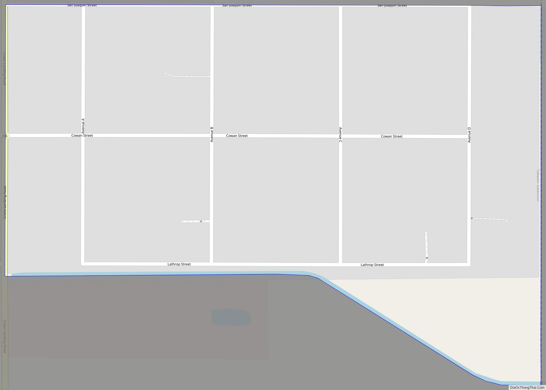
Map of Crestline CDP

Map of Crestline CDP, California

Crestline is a census-designated place in the San Bernardino Mountains of San Bernardino County, California, USA. The population was 10,770 at the 2010 census, up from 10,218 at the 2000 census. Crestline CDP overview: Name: Crestline CDP LSAD Code: 57 LSAD Description: CDP (suffix) State: California County: San Bernardino County Elevation: 4,613 ft (1,406 m) Total Area: … Read more

Map of Crest CDP

Map of Crest CDP

Crest is an unincorporated community in San Diego County, California. The Crest census-designated place (CDP) had a population of 2,593 at the 2010 census, down from 2,716 at the 2000 census. Crest CDP overview: Name: Crest CDP LSAD Code: 57 LSAD Description: CDP (suffix) State: California County: San Diego County Elevation: 1,640 ft (400 m) Total Area: … Read more

Map of Cressey CDP

Map of Cressey CDP

Cressey (formerly, Cressy) is a census-designated place in Merced County, California. It is located 6 miles (9.7 km) north-northwest of Atwater, at an elevation of 167 feet (51 m). The population was 366 at the 2020 United States census, down from 393 in 2010. Cressey is located in the northern part of Merced County. It is … Read more

Map of Cromberg CDP

Map of Cromberg CDP

Cromberg (formerly, Twenty-Mile House, Taft, and Teft) is a census-designated place (CDP) in Plumas County, California, United States. Cromberg is located on the Western Pacific Railroad, 6.5 miles (10.5 km) northwest of Blairsden. The population was 261 at the 2010 census, down from 290 at the 2000 census. Cromberg CDP overview: Name: Cromberg CDP LSAD Code: … Read more

Map of Crockett CDP

Map of Crockett CDP, California

Crockett (formerly Crockettville) is a census-designated place (CDP) in Contra Costa County, in the East Bay sub-region of the San Francisco Bay Area, California. The population was 3,094 at the 2010 census. It is located 28 miles northeast of San Francisco. Other nearby communities include Port Costa, Martinez, Vallejo, Benicia, Rodeo, Hercules, Pinole and Richmond. … Read more

Map of Creston CDP

Map of Creston CDP, California

Creston is a census-designated place in San Luis Obispo County, California, about 10 miles east of Atascadero. Creston CDP overview: Name: Creston CDP LSAD Code: 57 LSAD Description: CDP (suffix) State: California County: San Luis Obispo County Total Area: 0.57 sq mi (1.47 km²) Land Area: 0.56 sq mi (1.46 km²) Water Area: 0.01 sq mi (0.01 km²)  0.84% Total Population: 98 Population Density: … Read more

Map of Cudahy city

Map of Cudahy city, California

Cudahy (/ˈkʌdəheɪ/ KUD-ə-hay) is a city located in southeastern Los Angeles County, California, United States. In area, Cudahy is the second smallest city in Los Angeles County after Hawaiian Gardens but with one of the highest population densities of any incorporated city in the United States. It is part of the Gateway Cities region and … Read more

Map of Crows Landing CDP

Map of Crows Landing CDP

Crows Landing is a census-designated place (CDP) in Stanislaus County, California. Crows Landing is about 20 miles (32 km) southwest of Modesto. Crows Landing sits at an elevation of 128 feet (39 m). The 2020 United States census reported Crows Landing’s population was 322. Crows Landing CDP overview: Name: Crows Landing CDP LSAD Code: 57 LSAD Description: … Read more

Map of Crowley Lake CDP

Map of Crowley Lake CDP

Crowley Lake is a census-designated place in Mono County, California. Crowley Lake sits at an elevation of 6,949 feet (2,118 m). The 2020 United States census reported Crowley Lake’s population was 980. Crowley Lake CDP overview: Name: Crowley Lake CDP LSAD Code: 57 LSAD Description: CDP (suffix) State: California County: Mono County Elevation: 6,949 ft (2,118 m) Total … Read more

Map of Cutler CDP

Map of Cutler CDP, California

Cutler is a community and census-designated place (CDP) in Tulare County, California, United States. The population was 5,000 at the 2010 census, up from 4,491 at the 2000 census. The population as of 2019 was 5,214. Cutler CDP overview: Name: Cutler CDP LSAD Code: 57 LSAD Description: CDP (suffix) State: California County: Tulare County Elevation: … Read more

Map of Cupertino city

Map of Cupertino city

Cupertino (/ˌkuːpərˈtiːnoʊ/ KOOP-ər-TEEN-oh) is a city in Santa Clara County, California, United States, directly west of San Jose on the western edge of the Santa Clara Valley with portions extending into the foothills of the Santa Cruz Mountains. The population was 60,381 as of the 2020 census. It is known for being the home of … Read more

Map of Culver City city

Map of Culver City

Culver City is a city in Los Angeles County, California, United States. As of the 2020 census, the population was 40,779. In the 1920s, the city became a center for film and later television production, best known as the home of Metro-Goldwyn-Mayer studios from 1924 to 1986. From 1932 to 1986, it was the headquarters … Read more