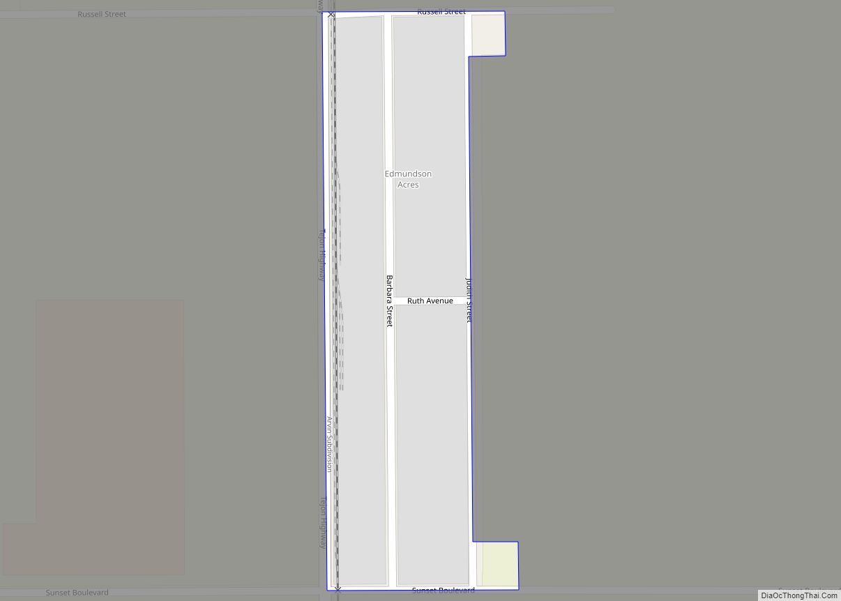
Map of El Cerrito CDP

Map of El Cerrito CDP

El Cerrito (Spanish for “The Little Hill”) is a census-designated place (CDP) in Riverside County, California, United States. It is an unincorporated area mostly surrounded by the city of Corona. The population was 5,100 at the 2010 census, up from 4,590 at the 2000 census. El Cerrito CDP overview: Name: El Cerrito CDP LSAD Code: … Read more

Map of El Centro city

Map of El Centro city

El Centro (Spanish for “The Center”) is a city and county seat of Imperial County, California, United States. El Centro is the largest city in the Imperial Valley, the east anchor of the Southern California Border Region, and the core urban area and principal city of the El Centro metropolitan area which encompasses all of … Read more

Map of El Cajon city

Map of El Cajon city

El Cajon (/ɛl kəˈhoʊn/ el kə-HOHN, American Spanish: [el kaˈxon]; Spanish: El Cajón, meaning “the box”) is a city in San Diego County, California, United States, 17 mi (27 km) east of downtown San Diego. The city takes its name from Rancho El Cajón, which was in turn named for the box-like shape of the valley that surrounds … Read more

Map of El Dorado Hills CDP

Map of El Dorado Hills CDP

El Dorado Hills (El Dorado, Spanish for “The Golden”) is an unincorporated town and census-designated place in El Dorado County, California. Located in the Greater Sacramento region of Northern California, it had a population was 50,547 at the 2020 census, up from 42,108 at the 2010 census. El Dorado Hills is primarily an affluent suburb … Read more

Map of El Nido CDP

Map of El Nido CDP

El Nido (Spanish for “The Nest”) is a census-designated place in Merced County, California. It is located 11 miles (18 km) south of Merced at an elevation of 141 feet (43 m), on California State Route 59. The community had a population of 331 at the 2020 census. El Nido CDP overview: Name: El Nido CDP LSAD … Read more

Map of El Granada CDP

Map of El Granada CDP

El Granada is a village and census-designated place (CDP) in the coastal area of northern San Mateo County, California, United States. The population was 5,481 at the 2020 census. The village is named for the city of Granada, Spain. El Granada CDP overview: Name: El Granada CDP LSAD Code: 57 LSAD Description: CDP (suffix) State: … Read more

Map of El Rancho CDP

Map of El Rancho CDP, California

El Rancho is a census-designated place (CDP) in Tulare County, California. El Rancho sits at an elevation of 390 feet (120 m). The 2010 United States census reported El Rancho’s population was 124. El Rancho CDP overview: Name: El Rancho CDP LSAD Code: 57 LSAD Description: CDP (suffix) State: California County: Tulare County Elevation: 390 ft (120 m) … Read more

Map of El Portal CDP

Map of El Portal CDP, California

El Portal (Spanish for “The Gateway”) is a census-designated place in Mariposa County, California, United States. It is located 11.5 miles (19 km) west-southwest of Yosemite Village, at an elevation of 1,939 feet (591 m). The population was 372 at the 2020 census, down from 474 at the 2010 census. El Portal CDP overview: Name: El Portal … Read more

Map of City of El Paso de Robles (Paso Robles)

Map of City of El Paso de Robles (Paso Robles)

Paso Robles (/ˌpæsə ˈroʊbəlz/ PASS-oh ROH-buhlz), officially El Paso de Robles (Spanish for “The Pass of Oaks”), is a city in San Luis Obispo County, California, United States. Located on the Salinas River approximately 30 miles (48 km) north of San Luis Obispo, the city is known for its hot springs, its abundance of wineries, its … Read more

Map of El Sobrante CDP

Map of El Sobrante CDP

El Sobrante (Spanish for “the leftovers”, “surplus”, or “remaining land”) is a census-designated place in Riverside County, California. El Sobrante sits at an elevation of 1,283 feet (391 m). The 2010 United States census reported El Sobrante’s population was 12,723. El Sobrante CDP overview: Name: El Sobrante CDP LSAD Code: 57 LSAD Description: CDP (suffix) State: … Read more

Map of El Segundo city

Map of El Segundo city

El Segundo (Spanish for ‘The Second’; /ˌɛl səˈɡʌndoʊ/; EL sə-GUN-doh; Spanish: [el seˈɣundo]) is a city in Los Angeles County, California. Located on Santa Monica Bay, it was incorporated on January 18, 1917, and is part of the South Bay Cities Council of Governments. The population was 16,731 as of the 2020 census, a 0.5% increase … Read more

Map of El Rio CDP

Map of El Rio CDP

El Rio (/ɛl ˈriːoʊ/ (listen); Spanish: El Río, meaning “The River”) is a small, rural unincorporated town in Ventura County, California, United States, on the northeast side of the 101 Freeway and Oxnard, and south of the Santa Clara River. The town was founded in 1875 and named New Jerusalem by the owner of general … Read more