El Cajon (/ɛl kəˈhoʊn/ el kə-HOHN, American Spanish: [el kaˈxon]; Spanish: El Cajón, meaning “the box”) is a city in San Diego County, California, United States, 17 mi (27 km) east of downtown San Diego. The city takes its name from Rancho El Cajón, which was in turn named for the box-like shape of the valley that surrounds the city, which is also the origin of the city’s common nickname of “the Box”.
| Name: | El Cajon city |
|---|---|
| LSAD Code: | 25 |
| LSAD Description: | city (suffix) |
| State: | California |
| County: | San Diego County |
| Incorporated: | November 12, 1912 |
| Elevation: | 433 ft (132 m) |
| Total Area: | 14.51 sq mi (37.58 km²) |
| Land Area: | 14.51 sq mi (37.58 km²) |
| Water Area: | 0.00 sq mi (0.00 km²) 0% |
| Total Population: | 106,215 |
| Population Density: | 7,300/sq mi (2,800/km²) |
| Area code: | 619 |
| FIPS code: | 0621712 |
| Website: | www.ci.el-cajon.ca.us |
Online Interactive Map
Click on ![]() to view map in "full screen" mode.
to view map in "full screen" mode.
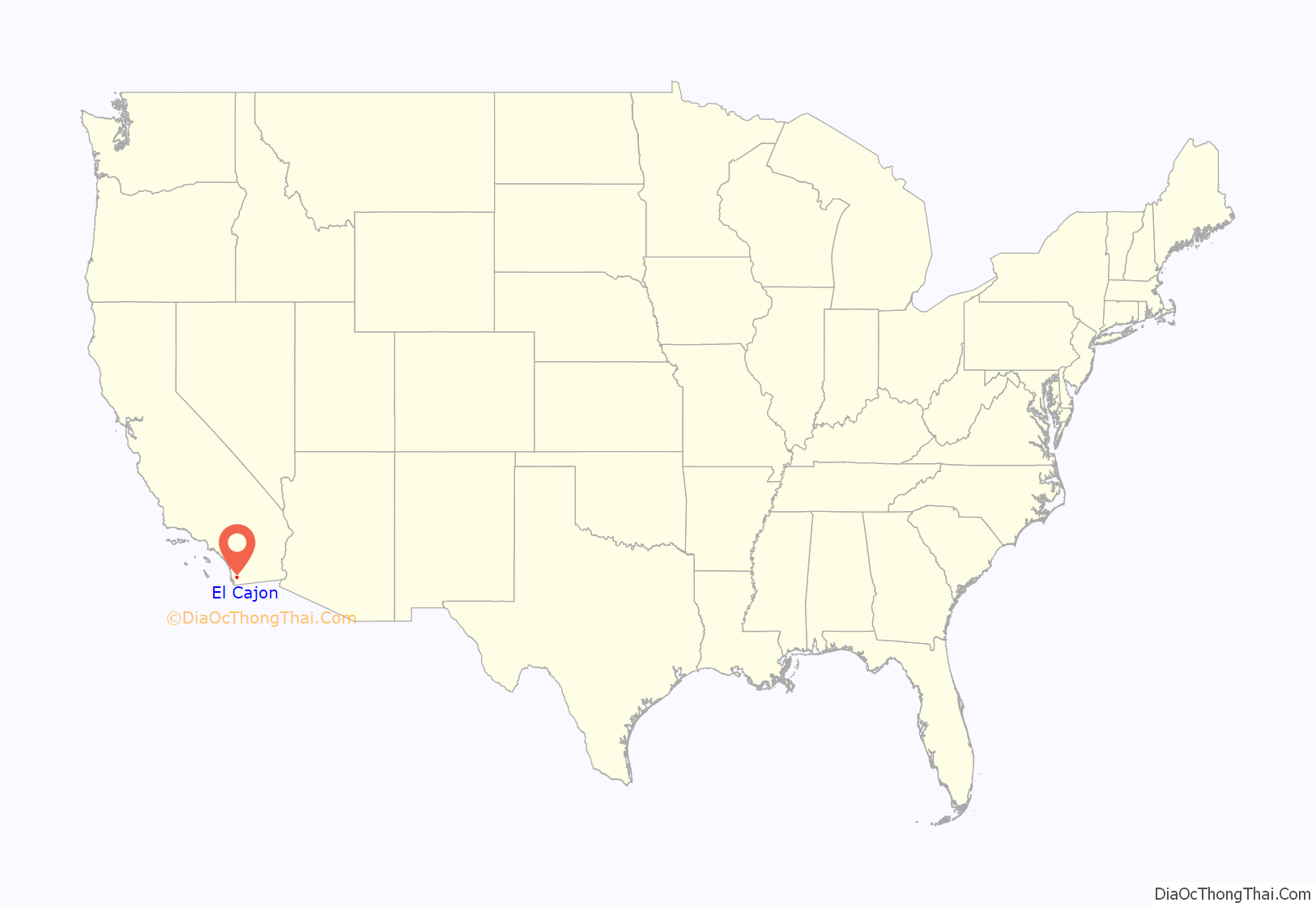
El Cajon location map. Where is El Cajon city?

History
During Spanish rule (1769–1821), the government encouraged settlement of territory now known as California by the establishment of large land grants called ranchos, from which the English word “ranch” is derived. Land grants were made to the Roman Catholic Church, which set up numerous missions throughout the region. In the early 19th century, mission padres’ search for pastureland led them to the El Cajon Valley. Surrounding foothills served as a barrier to straying cattle and a watershed to gather the sparse rainfall. For years, the pasturelands of El Cajon supported the cattle herds of the mission and its native Indian converts.
Titles to plots of land were not granted to individuals until the Mexican era (1821–1846). The original intent of the 1834 secularization legislation was to have church property divided among the former mission Indians, but most of the grants were actually made to rich “Californios” of Spanish background who had long been casting envious eyes on the vast holdings of the Roman Catholic missions. In 1845, California Governor Pio Pico confiscated the lands of Mission San Diego de Alcala. He granted 11 square leagues (about 48,800 acres or 19,700 ha) of the El Cajon Valley to Dona Maria Antonio Estudillo, daughter of José Antonio Estudillo, alcalde of San Diego, to repay a $500 government obligation. The grant was originally called Rancho Santa Monica and encompassed present-day El Cajon, Bostonia, Santee, Lakeside, Flinn Springs, and the eastern part of La Mesa. It also contained the 28-acre (11 ha) Rancho Cañada de los Coches grant. Maria Estudillo was the wife of Don Miguel Pedrorena (1808–1850), a native of Madrid, Spain, who had come to California from Peru in 1838 to operate a trading business.
With the cession of California to the United States following the Mexican–American War, the 1848 Treaty of Guadalupe Hidalgo provided that the land grants would be honored. As required by the Land Act of 1851, a claim for Rancho El Cajon was filed by Thomas W. Sutherland, guardian of Pedrorena’s heirs (his son, Miguel, and his three daughters, Victoria, Ysabel, and Elenain) with the Public Land Commission in 1852, confirmed by the U.S. Supreme Court, and the grant was patented in 1876. In 1868, Los Angeles land developer Isaac Lankershim bought the bulk of the Pedrorena’s Rancho El Cajon holdings and employed Major Levi Chase, a former Union Army officer, as his agent. Chase received from Lankershim 7,624 acres (3,090 ha) known as the Chase Ranch. Lankershim hired Amaziah Lord Knox (1833–1918), a New Englander whom he had met in San Francisco, to manage Rancho El Cajon. In 1876, Knox established a hotel there to serve the growing number of people traveling between San Diego and Julian, where gold had been discovered in 1869. Room and board for a guest and horse cost $1 a night. The area became known as Knox’s Corners and was later renamed. By 1878 there were 25 families living in the valley and a portion of the hotel lobby became the valley post office with Knox as the first postmaster.
El Cajon was incorporated as a city in 1912. For the first half of the 20th century, El Cajon was known for its grape, avocado, and citrus agriculture.
In the 1960s and 1970s, Frontier Town, Big Oak Ranch, was a tourist attraction, featuring a typical frontier-town theme park and a periodic simulated shootout. The park closed around 1980 and is being used for residential housing.
Cajon Speedway was a 70-acre race track (28 ha) that operated from 1961 to 2005, which was founded by Earle Brucker Jr. of the El Cajon Stock Car Racing Association. One of his sons, Steve Brucker, later took over ownership of the track. Though closing after the death of Steve Brucker, it is a historic museum featuring the original entrance sign with the slogan “The fastest 3/8-mile paved oval in the West.”
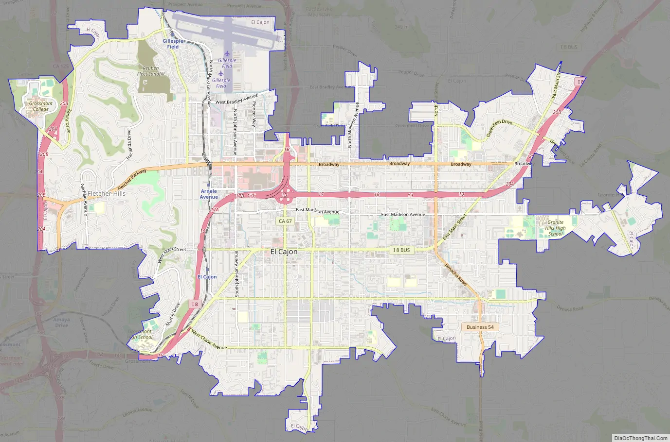
El Cajon Road Map
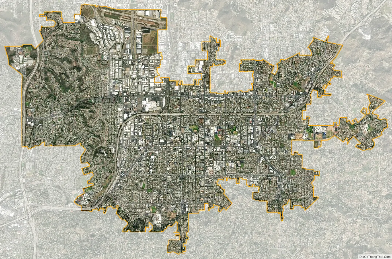
El Cajon city Satellite Map
Geography
According to the United States Census Bureau, the city has a total area of 14.4 square miles (37 km), all land. It is bordered by San Diego and La Mesa on the west, Spring Valley on the south, Santee on the north, and unincorporated San Diego County on the east. It includes the neighborhoods of Fletcher Hills, Bostonia, and Rancho San Diego.
Climate
Under the Köppen climate classification, El Cajon straddles areas of Mediterranean climate (Csa) and semiarid climate (BSh). As a result, it is often described as “arid Mediterranean” and “semiarid steppe”. Like most inland areas in Southern California, the climate varies dramatically within a short distance, known as microclimate. El Cajon’s climate has greater extremes compared to coastal San Diego. The farther east from the coast, the more arid the climate gets, until one reaches the mountains, where precipitation increases due to orographic uplift.
El Cajon’s climate is warm during summer with mean temperatures averaging 70.1 °F (21.2 °C) or higher and cool during winter with mean temperatures averaging 55.4 °F (13.0 °C) or higher.
The average high in the summer ranges from about 80 to 90 °F (27 to 32 °C), with temperatures reaching as high as over 105 °F (41 °C). The coldest month of the year is December with an average maximum temperature of 63 °F (17 °C) and an average minimum of 47 °F (8 °C), occasionally reaching below 39 °F (4 °C).
Temperature variations between night and day tend to be moderate with an average difference of 24 °F (13 °C) during the summer, and an average difference of 26 °F (14 °C) during the winter.
The annual average precipitation at El Cajon is 19 inches (480 mm), nearly twice the average of San Diego, and similar to Pasadena and the San Francisco Bay Area. Rainfall is fairly evenly distributed throughout the winter, but rare in summer. The wettest month of the year is December with an average rainfall of 3.80 inches (97 mm).
The record high temperature was 114 °F (46 °C) on September 5, 2020. The record low temperature was 19 °F (−7 °C) on January 8, 1913. The wettest year was 1941 with 28.14 inches (715 mm) and the driest year was 1989 with 1.51 inches (38 mm). The most rainfall in one month was 11.43 inches (290 mm) in January 1993. The most rainfall in 24 hours was 5.60 inches (142 mm) on January 27, 1916. A rare snowfall in November 1992 totaled 0.3 inches (7.6 mm). Three inches (7.6 cm) of snow covered the ground in January 1882.
See also
Map of California State and its subdivision:- Alameda
- Alpine
- Amador
- Butte
- Calaveras
- Colusa
- Contra Costa
- Del Norte
- El Dorado
- Fresno
- Glenn
- Humboldt
- Imperial
- Inyo
- Kern
- Kings
- Lake
- Lassen
- Los Angeles
- Madera
- Marin
- Mariposa
- Mendocino
- Merced
- Modoc
- Mono
- Monterey
- Napa
- Nevada
- Orange
- Placer
- Plumas
- Riverside
- Sacramento
- San Benito
- San Bernardino
- San Diego
- San Francisco
- San Joaquin
- San Luis Obispo
- San Mateo
- Santa Barbara
- Santa Clara
- Santa Cruz
- Shasta
- Sierra
- Siskiyou
- Solano
- Sonoma
- Stanislaus
- Sutter
- Tehama
- Trinity
- Tulare
- Tuolumne
- Ventura
- Yolo
- Yuba
- Alabama
- Alaska
- Arizona
- Arkansas
- California
- Colorado
- Connecticut
- Delaware
- District of Columbia
- Florida
- Georgia
- Hawaii
- Idaho
- Illinois
- Indiana
- Iowa
- Kansas
- Kentucky
- Louisiana
- Maine
- Maryland
- Massachusetts
- Michigan
- Minnesota
- Mississippi
- Missouri
- Montana
- Nebraska
- Nevada
- New Hampshire
- New Jersey
- New Mexico
- New York
- North Carolina
- North Dakota
- Ohio
- Oklahoma
- Oregon
- Pennsylvania
- Rhode Island
- South Carolina
- South Dakota
- Tennessee
- Texas
- Utah
- Vermont
- Virginia
- Washington
- West Virginia
- Wisconsin
- Wyoming


