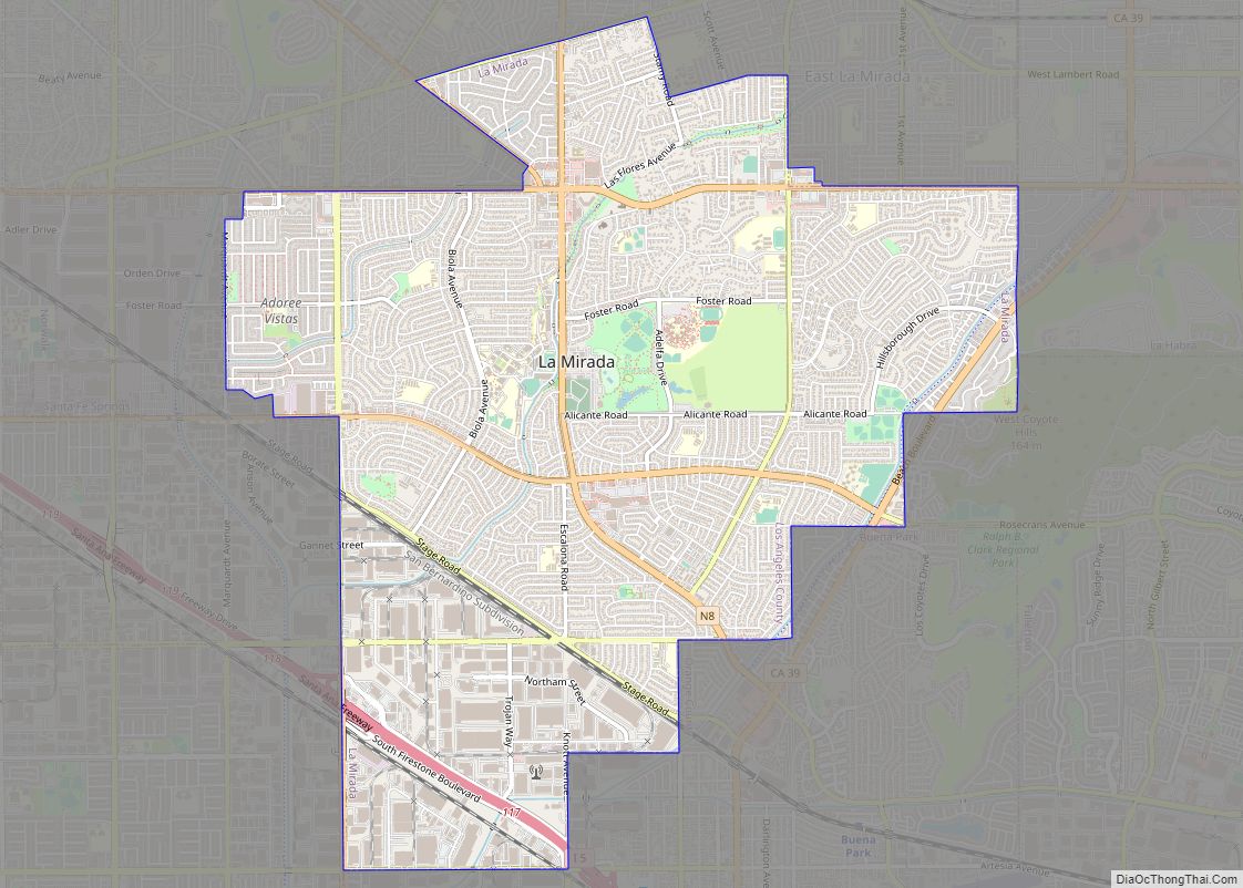
Map of La Quinta city

Map of La Quinta city

La Quinta (Spanish for ‘the fifth’) is a desert resort city in Riverside County, California, United States. Located between Indian Wells and Indio, it is one of the nine cities of the Coachella Valley. The population was 37,467 at the 2010 census, up from 23,694 at the 2000 census. The Robb Report credits La Quinta … Read more

Map of La Puente city

Map of La Puente city

La Puente (Spanish for “The Bridge”) is a city in Los Angeles County, California, United States. The city had a population of 39,816 at the 2010 census and is approximately 20 miles (32 km) east of downtown Los Angeles. La Puente city overview: Name: La Puente city LSAD Code: 25 LSAD Description: city (suffix) State: California … Read more

Map of La Presa CDP

Map of La Presa CDP, California

La Presa (Spanish for “The Dam”) is a census-designated place (CDP) in the East County region of San Diego County, California, United States. The population was 34,169 at the 2010 census, up from 32,721 at the 2000 census. La Presa belonged to the neighboring Spring Valley CDP from its inception in 1970 through 1990. It … Read more

Map of La Selva Beach CDP

Map of La Selva Beach CDP

La Selva Beach (La Selva, Spanish for “The Forest”) is a census-designated place (CDP) in Santa Cruz County, California. La Selva Beach sits at an elevation of 151 feet (46 m). The 2020 United States census reported La Selva Beach’s population was 2,531. La Selva Beach is one of the several small communities located in and … Read more

Map of La Riviera CDP

Map of La Riviera CDP

La Riviera is a census-designated place (CDP) in Sacramento County, California, United States. It is part of the Sacramento–Arden-Arcade–Roseville Metropolitan Statistical Area. The population was 10,802 at the 2010 census, up from 10,273 at the 2000 census. La Riviera is a primarily residential neighborhood located between the American River on the North side and Highway … Read more

Map of La Verne city

Map of La Verne city

La Verne is a city in Los Angeles County, California, United States. The population was 31,063 at the 2010 census, down from 31,638 at the 2000 census. La Verne city overview: Name: La Verne city LSAD Code: 25 LSAD Description: city (suffix) State: California County: Los Angeles County Incorporated: August 20, 1906 Elevation: 1,060 ft (323 m) … Read more

Map of Ladera Ranch CDP

Map of Ladera Ranch CDP

Ladera Ranch is a master-planned community and census-designated place located in south Orange County, California, just outside the city limits of San Juan Capistrano, Rancho Santa Margarita and Mission Viejo. Ladera Ranch CDP overview: Name: Ladera Ranch CDP LSAD Code: 57 LSAD Description: CDP (suffix) State: California County: Orange County Elevation: 404 ft (123 m) Total Area: … Read more

Map of Ladera Heights CDP

Map of Ladera Heights CDP

Ladera Heights is a community and unincorporated area in Los Angeles County, California. The population was 6,634 at the 2020 census. Culver City lies to its west, the Baldwin Hills neighborhood to its north, the View Park-Windsor Hills community to its east, the Westchester neighborhood to its south and southwest and the city of Inglewood … Read more

Map of La Vina CDP

Map of La Vina CDP

La Vina (Spanish: La Viña, meaning “The Vine”) is a census-designated place in Madera County, California, United States. It is located 8 miles (13 km) by road south-southwest of Madera, at an elevation of 230 feet (70 m). The population was 637 at the 2020 census, up from 279 in 2010. A post office operated at La … Read more

Map of Laguna Beach city

Map of Laguna Beach city, California

Laguna Beach (/ləˈɡuːnə/; Laguna, Spanish for “Lagoon”) is a city in Orange County, California, United States. Located in Southern California along the Pacific Ocean, this seaside resort city has a mild year-round climate, scenic coves, and environmental preservation efforts. The population in the 2020 census was 23,032. Historically settled by Paleoindians, the Tongva people, and … Read more

Map of Lafayette city

Map of Lafayette city, California

Lafayette (formerly La Fayette) is a city in Contra Costa County, California, United States. As of 2020, the city’s population was 25,391. It was named after the Marquis de Lafayette, a French military officer of the American Revolutionary War. Lafayette city overview: Name: Lafayette city LSAD Code: 25 LSAD Description: city (suffix) State: California County: … Read more

Map of Ladera CDP

Map of Ladera CDP

Ladera is a census-designated place (CDP) in southern San Mateo County, California, adjacent to Portola Valley. Primarily a residential community, it comprises approximately 520 homes, governed by the Ladera Community Association. The ZIP Code is 94028 and the community is inside area code 650. The population was 1,557 at the 2020 census. Ladera CDP overview: … Read more