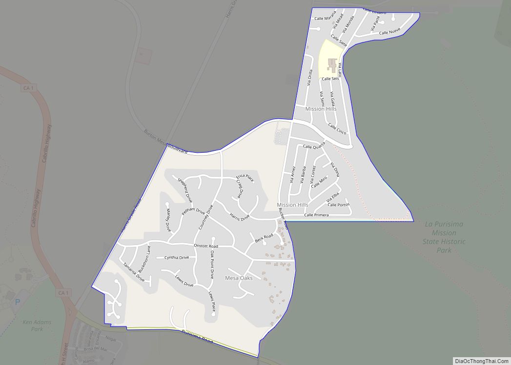
Map of Mokelumne Hill CDP

Map of Mokelumne Hill CDP

Mokelumne Hill (Mokelumne, Miwok for “People of the Fish Net”) is a census-designated place (CDP) in Calaveras County, California, United States. The population was 646 at the 2010 census, down from 774 at the 2000 census. It is commonly referred to as “Moke Hill” by locals. The town takes its name from the neighboring Mokelumne … Read more

Map of Mojave CDP

Map of Mojave CDP

Mojave (formerly Mohave) is an unincorporated community in Kern County, California, United States. Mojave is located 50 miles (80 km) east of Bakersfield, and 100 miles (161 km) north of Los Angeles, at an elevation of 2,762 feet (842 m). The town is located in the western region of the Mojave Desert, below and east of Oak Creek … Read more

Map of Mohawk Vista CDP

Map of Mohawk Vista CDP

Mohawk Vista is a census-designated place in Plumas County, California, United States. The population was 159 at the 2010 census, up from 121 at the 2000 census. Mohawk Vista CDP overview: Name: Mohawk Vista CDP LSAD Code: 57 LSAD Description: CDP (suffix) State: California County: Plumas County Elevation: 4,944 ft (1,507 m) Total Area: 11.961 sq mi (30.979 km²) Land … Read more

Map of Mono Vista CDP

Map of Mono Vista CDP

Mono Vista is a census-designated place (CDP) in Tuolumne County, California, United States. The population was 3,127 at the 2010 census, up from 3,072 at the 2000 census. Mono Vista CDP overview: Name: Mono Vista CDP LSAD Code: 57 LSAD Description: CDP (suffix) State: California County: Tuolumne County Elevation: 2,992 ft (912 m) Total Area: 2.839 sq mi (7.352 km²) … Read more

Map of Mono City CDP

Map of Mono City CDP

Mono City is an unincorporated community and census-designated place (CDP) in Mono County, California, United States. It lies north of Mono Lake at the base of the Sierra Nevada at the junction of U.S. Route 395 and California State Route 167, at an elevation of 6,768 feet (2,063 m). The ZIP Code is 93541; mail to … Read more

Map of Monmouth CDP

Map of Monmouth CDP, California

Monmouth is a census-designated place in Fresno County, California. It is located 7.25 miles (12 km) west of Selma, at an elevation of 276 feet (84 m). At the 2010 census, Monmouth had a population of 152. Officials of the Atchison, Topeka and Santa Fe Railroad (Monmouth was a stop on the railroad’s Valley Division) named … Read more

Map of Montague city

Map of Montague city, California

Montague is a city in Siskiyou County, California, United States. Its population is 1,226 as of the 2020 census, down from 1,443 from the 2010 census. Montague city overview: Name: Montague city LSAD Code: 25 LSAD Description: city (suffix) State: California County: Siskiyou County Incorporated: January 28, 1909 Elevation: 2,539 ft (774 m) Total Area: 1.79 sq mi (4.64 km²) … Read more

Map of Monson CDP

Map of Monson CDP

Monson is a census-designated place (CDP) in Tulare County, California. Monson sits at an elevation of 325 feet (99 m). The 2010 United States census reported Monson’s population was 188. Monson CDP overview: Name: Monson CDP LSAD Code: 57 LSAD Description: CDP (suffix) State: California County: Tulare County Elevation: 325 ft (99 m) Total Area: 0.492 sq mi (1.274 km²) Land … Read more

Map of Monrovia city

Map of Monrovia city, California

Monrovia is a city in the foothills of the San Gabriel Mountains in the San Gabriel Valley of Los Angeles County, California, United States. The population was 37,931 at the 2020 census. Monrovia has been used for filming TV shows, movies and commercials. Monrovia city overview: Name: Monrovia city LSAD Code: 25 LSAD Description: city … Read more

Map of Montclair city

Map of Montclair city, California

Montclair is a city in the Pomona Valley, in southwestern San Bernardino County, California. The population was 36,664 in the 2010 United States Census. Montclair city overview: Name: Montclair city LSAD Code: 25 LSAD Description: city (suffix) State: California County: San Bernardino County Incorporated: April 25, 1956 Elevation: 1,066 ft (325 m) Total Area: 5.53 sq mi (14.33 km²) Land … Read more

Map of Montara CDP

Map of Montara CDP

Montara (/mɒnˈtærə/) is a census-designated place (CDP) in San Mateo County, California, United States. The population was 2,833 at the 2020 census. Nearby communities include Moss Beach and Princeton-by-the-Sea. Montara CDP overview: Name: Montara CDP LSAD Code: 57 LSAD Description: CDP (suffix) State: California County: San Mateo County Elevation: 98 ft (30 m) Total Area: 3.878 sq mi (10.045 km²) … Read more

Map of Montalvin Manor CDP

Map of Montalvin Manor CDP

Montalvin Manor (formerly, Montalvin) is a census-designated place (CDP) in Contra Costa County, California. It lies at an elevation of 69 feet (21 m). For census purposes, it formed part of Bayview-Montalvin, California until 2010, when it became a separate CDP with a population of 2,876. The other half of the old CDP became Bayview. … Read more