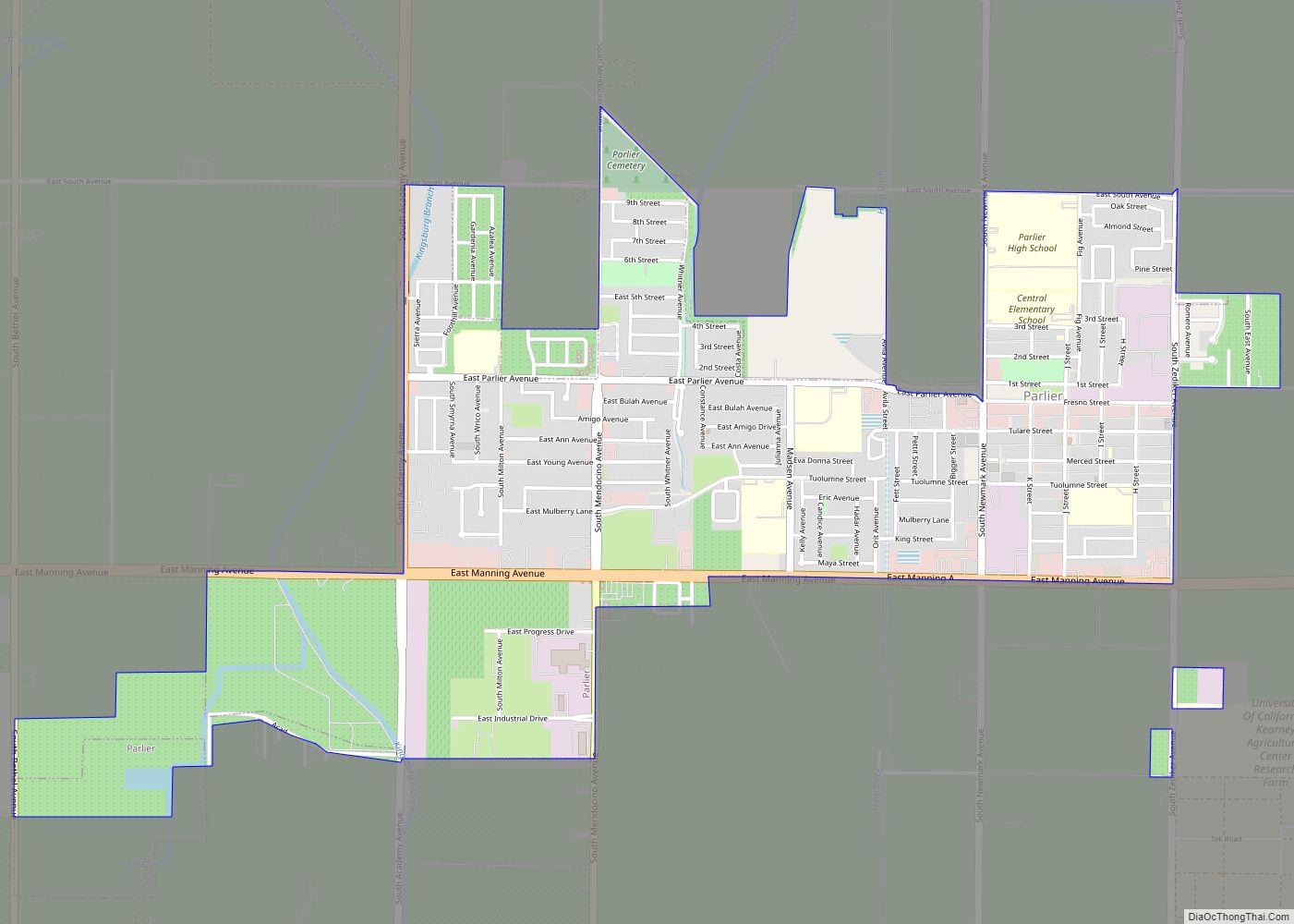
Map of Patton Village CDP

Map of Patton Village CDP, California

Patton Village is a census-designated place in Lassen County, California. It lies at an elevation of 4111 feet (1253 m). Its population is 632 as of the 2020 census, down from 702 from the 2010 census. Patton Village CDP overview: Name: Patton Village CDP LSAD Code: 57 LSAD Description: CDP (suffix) State: California County: Lassen … Read more

Map of Patterson city, California

Map of Patterson city, California

Patterson is a city in Stanislaus County, California, United States, located off Interstate 5. It is 27 miles (43 km) southeast of Tracy and is part of the Modesto Metropolitan Statistical Area. Patterson is known as the “Apricot Capital of the World”; the town holds an annual Apricot Fiesta to celebrate with many drinks, food, desserts … Read more

Map of Patterson Tract CDP

Map of Patterson Tract CDP

Patterson Tract is a census-designated place (CDP) in Tulare County, California. Patterson Tract sits at an elevation of 328 feet (100 m). The 2010 United States census reported Patterson Tract’s population was 1,752. Patterson Tract CDP overview: Name: Patterson Tract CDP LSAD Code: 57 LSAD Description: CDP (suffix) State: California County: Tulare County Elevation: 328 ft (100 m) … Read more

Map of Pearsonville CDP

Map of Pearsonville CDP

Pearsonville is a census-designated place (CDP) in Inyo County, California, United States. The population was 17 at the 2010 census, down from 27 at the 2000 census. Pearsonville has been dubbed the “Hubcap Capital of the World” because of resident Lucy Pearson’s collection of hubcaps, which are rumored to number over 80,000. Pearsonville CDP overview: … Read more

Map of Paynes Creek CDP

Map of Paynes Creek CDP

Paynes Creek is a census-designated place (CDP) in Tehama County, California. It is 23 miles (37 km) east of Red Bluff. Its ZIP code is 96075 and telephone prefixes follow (530-597-xxxx), which is shared with the town of Dales, about 9 miles (14 km) to the west. Paynes Creek sits at an elevation of 1,949 feet (594 m). … Read more

Map of Paxton CDP

Map of Paxton CDP, California

Paxton is a census-designated place (CDP) in Plumas County, California, United States. The population was 14 at the 2010 census, down from 21 at the 2000 census. Paxton CDP overview: Name: Paxton CDP LSAD Code: 57 LSAD Description: CDP (suffix) State: California County: Plumas County Elevation: 2,969 ft (905 m) Total Area: 0.334 sq mi (0.864 km²) Land Area: 0.334 sq mi … Read more

Map of Penryn CDP

Map of Penryn CDP, California

Penryn (Washo: Pénwin) is a census-designated place in Placer County, California, in the United States. Geographic location is 38°51′08″N 121°10′06″W / 38.85222°N 121.16833°W / 38.85222; -121.16833. Penryn is located 5.5 miles (8.9 km) northeast of Rocklin. The community’s ZIP code is 95663 and is in area codes 916 and 279. The population was 831 at the … Read more

Map of Penngrove CDP

Map of Penngrove CDP

Penngrove is a census-designated place (CDP) in Sonoma County, California, United States, situated between the cities of Petaluma and Cotati, at the foot of the western flank of Sonoma Mountain. It is part of the North Bay subregion of the San Francisco Bay Area. The population was 2,522 at the 2010 census. The area is … Read more

Map of Penn Valley CDP

Map of Penn Valley CDP

Penn Valley is a census-designated place (CDP) in Nevada County, California. The population was 1,621 at the 2010 census, up from 1,387 at the 2000 census. Penn Valley CDP overview: Name: Penn Valley CDP LSAD Code: 57 LSAD Description: CDP (suffix) State: California County: Nevada County Elevation: 1,401 ft (427 m) Total Area: 2.121 sq mi (5.495 km²) Land Area: … Read more

Map of Petaluma city

Map of Petaluma city

Petaluma (Miwok: Péta Lúuma) is a city in Sonoma County, California, located in the North Bay region of the San Francisco Bay Area. Its population was 59,776 according to the 2020 census. Petaluma’s name comes from the Miwok village named Péta Lúuma, that was located on the banks of the Petaluma River. The modern city … Read more

Map of Pescadero CDP

Map of Pescadero CDP

Pescadero (Spanish for “Fishmonger”) is an unincorporated town and census-designated place (CDP) in San Mateo County, California, two miles (3 km) east of State Route 1 and Pescadero State Beach. The town is 14.4 miles (23.2 km) south of Half Moon Bay. The ZIP Code is 94060 and the community is inside area code 650. The population … Read more

Map of Perris city

Map of Perris city

Perris is an old railway city in Riverside County, California, United States, located 71 miles (114 km) east-southeast of Los Angeles and 81 miles (130 km) north of San Diego. It is known for Lake Perris, an artificial lake, skydiving, and its sunny dry climate. Perris is within the Inland Empire metropolitan area of Southern California. Perris … Read more