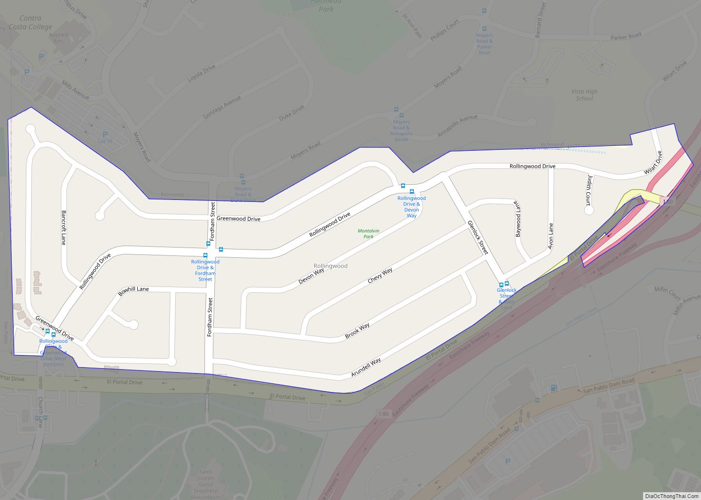
Map of Rosemead city

Map of Rosemead city

Rosemead is a city in Los Angeles County, California, United States. As of the 2021 census, it had a population of 50,245, currently dropping. Rosemead is part of a cluster of cities, along with Alhambra, Arcadia, Temple City, Monterey Park, San Marino, and San Gabriel, in the west San Gabriel Valley with a growing Asian-American … Read more

Map of Rosedale CDP

Map of Rosedale CDP, California

Rosedale is a census-designated place (CDP) in Kern County, California, United States. The population was 14,058 at the 2010 census, up from 8,445 at the 2000 census. Formerly a country town 10 miles (16 km) west of Bakersfield, it is now surrounded by suburban housing and currently has the highest household income in Kern County, according … Read more

Map of Rose Hills CDP

Map of Rose Hills CDP

Rose Hills (also known as North Whittier) is a census-designated place in Los Angeles County, California. Rose Hills sits at an elevation of 518 feet (158 m) above sea level. The 2010 United States census reported Rose Hills’s population was 2,803. The CDP consists primarily of the Spy Glass Hill section of unincorporated Whittier, which is … Read more

Map of Ross town

Map of Ross town, California

Ross is a small incorporated town in Marin County, California, United States, just north of San Francisco. Ross is located 1.5 miles (2.4 km) west-southwest of San Rafael, at an elevation of 36 feet (11 m). The population was 2,338 at the 2020 census. The town is bordered by San Rafael to the east, Kentfield to the … Read more

Map of Rosemont CDP

Map of Rosemont CDP, California

Rosemont is a census-designated place (CDP) in Sacramento County, California, United States. It is part of the Sacramento–Arden-Arcade–Roseville metropolitan area. The population rose to 23,510 at the 2020 census. It was 22,681 at the 2010 census, down from 22,904 at the 2000 census. Rosemont CDP overview: Name: Rosemont CDP LSAD Code: 57 LSAD Description: CDP … Read more

Map of Rossmoor CDP

Map of Rossmoor CDP, California

Rossmoor is a planned census-designated place located in Orange County, California. As of the 2020 census, the CDP had a total population of 10,625 up from the 2010 census population of 10,244. The gated Leisure World retirement community in the city of Seal Beach is to the south of Rossmoor, Los Alamitos is to the … Read more

Map of Round Valley CDP, California

Map of Round Valley CDP, California

Round Valley is a census-designated place (CDP) in Inyo County, California, United States. Round Valley is located 7.5 miles (12 km) northeast of Mount Tom, at an elevation of 4692 feet (1430 m). The population was 435 at the 2010 census, up from 278 at the 2000 census. Round Valley CDP overview: Name: Round Valley CDP … Read more

Map of Round Mountain CDP

Map of Round Mountain CDP, California

Round Mountain is a census-designated place in Shasta County, California, United States. Its population is 160 as of the 2020 census, up from 155 from the 2010 census. Round Mountain CDP overview: Name: Round Mountain CDP LSAD Code: 57 LSAD Description: CDP (suffix) State: California County: Shasta County Elevation: 2,080 ft (635 m) Total Area: 1.684 sq mi (4.360 km²) … Read more

Map of Rough and Ready CDP

Map of Rough and Ready CDP

Rough and Ready is a census-designated place in Nevada County, California, United States. It is located west of Grass Valley, California, approximately 62 miles (100 km) from Sacramento. The population was 963 at the 2010 census. It has frequently been noted on lists of unusual place names. Rough and Ready CDP overview: Name: Rough and Ready … Read more

Map of Running Springs CDP

Map of Running Springs CDP

Running Springs is a census-designated place (CDP) in San Bernardino County, California, United States. The population was 5,268 at the 2020 census, up from 4,862 at the 2010 census. Running Springs is situated 17 miles west of the city of Big Bear Lake. Running Springs is home to the 3,400-acre National Children’s Forest, which offers … Read more

Map of Rowland Heights CDP

Map of Rowland Heights CDP

Rowland Heights is an unincorporated area in and below the Puente Hills in the San Gabriel Valley, in Los Angeles County, California, United States. The population was 48,231 at the 2020 census. Rowland Heights is in the Los Angeles metropolitan area and represented by the County of Los Angeles (County Board of Supervisors) and is … Read more

Map of Rouse CDP

Map of Rouse CDP

Rouse is a census-designated place (CDP) in Stanislaus County, California. Rouse sits at an elevation of 89 feet (27 m). The 2010 United States census reported Rouse’s population was 2,005. Rouse CDP overview: Name: Rouse CDP LSAD Code: 57 LSAD Description: CDP (suffix) State: California County: Stanislaus County Elevation: 89 ft (27 m) Total Area: 0.238 sq mi (0.617 km²) Land … Read more