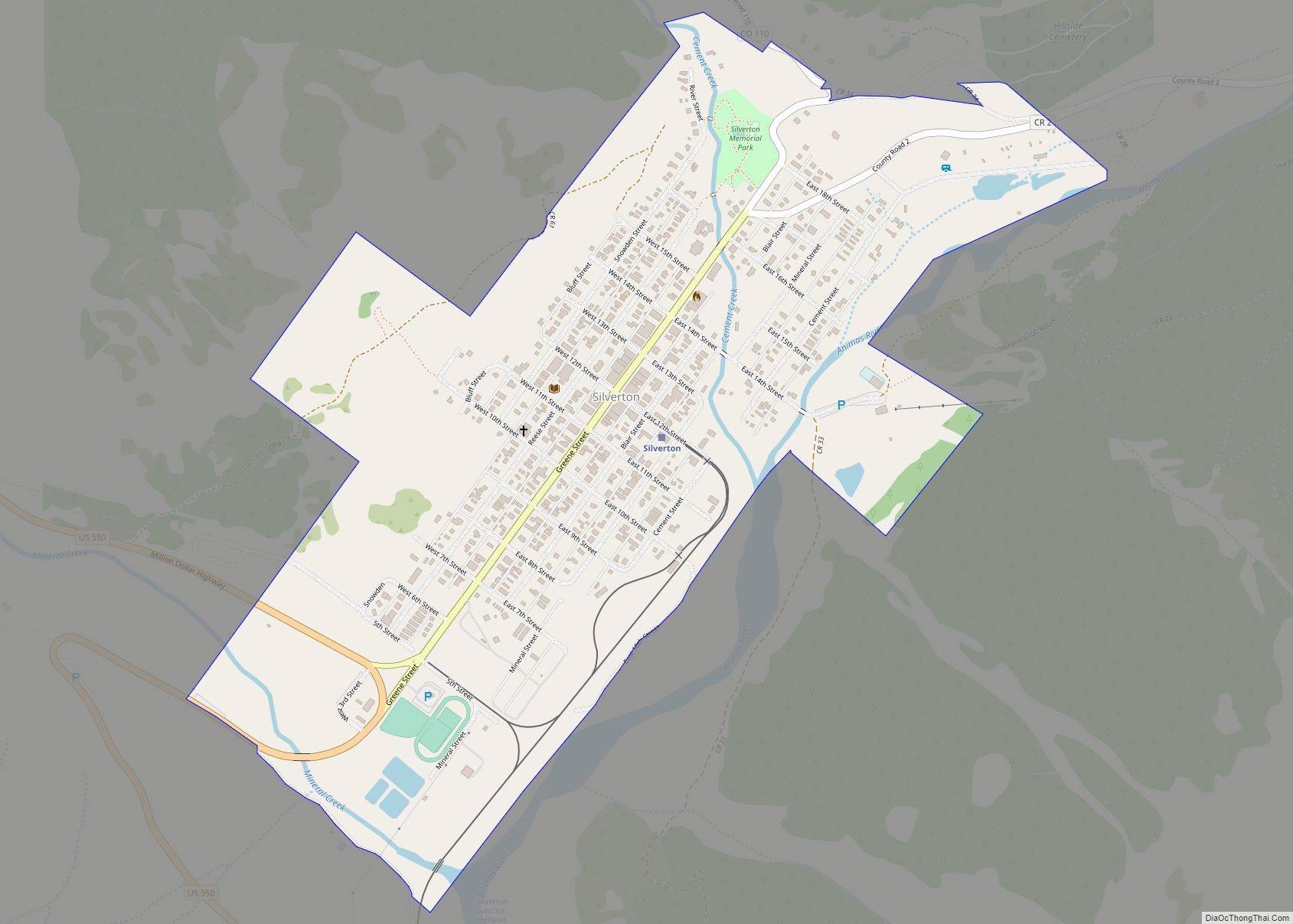
Map of Silverthorne town

Map of Silverthorne town

The Town of Silverthorne is a home rule municipality in Summit County, Colorado. According to the 2020 Census, the population of the city is 4,402. Silverthorne town overview: Name: Silverthorne town LSAD Code: 43 LSAD Description: town (suffix) State: Colorado County: Summit County Incorporated: September 5, 1967 Elevation: 9,035 ft (2,754 m) Total Area: 4.07 sq mi (10.54 km²) Land … Read more

Map of Silver Plume town

Map of Silver Plume town

Silver Plume is a Statutory Town located in Clear Creek County, Colorado, United States. Silver Plume is a former silver mining camp along Clear Creek in the Front Range of the Rocky Mountains. The federally designated Georgetown-Silver Plume Historic District comprises Silver Plume, the neighboring town of Georgetown, and the Georgetown Loop Historic Mining & … Read more

Map of Snowmass Village town

Map of Snowmass Village town

Snowmass Village is a home rule municipality in Pitkin County, Colorado, United States. The population was 3,096 at the 2020 census. A popular winter resort location for skiing and snowboarding, the town is well known as the location of the Snowmass ski area, the largest of the four nearby ski areas operated collectively as Aspen/Snowmass. … Read more

Map of Smeltertown CDP

Map of Smeltertown CDP

Smeltertown is an unincorporated community and a census-designated place (CDP) located in and governed by Chaffee County, Colorado, United States. The population of the Smeltertown CDP was 88 at the United States Census 2020. The Salida post office (Zip Code 81201) serves the area. Smeltertown CDP overview: Name: Smeltertown CDP LSAD Code: 57 LSAD Description: … Read more

Map of Simla town

Map of Simla town

Simla is a statutory town in Elbert County, Colorado, United States. It is 48 miles (77 km) northeast of Colorado Springs. The population was 601 at the time of the 2020 United States Census. Simla town overview: Name: Simla town LSAD Code: 43 LSAD Description: town (suffix) State: Colorado County: Elbert County Incorporated: January 15, 1912 … Read more

Map of Southern Ute CDP

Map of Southern Ute CDP

Southern Ute is a census-designated place (CDP) on the Southern Ute Indian Reservation in southern La Plata County, Colorado, United States. The CDP is a part of the Durango, CO Micropolitan Statistical Area. The population of the Southern Ute CDP was 158 at the United States Census 2020. The Ignacio post office (Zip Code 81137) … Read more

Map of South Fork town

Map of South Fork town, Colorado

South Fork is a statutory town in Rio Grande County, Colorado, United States. It lies at the confluence of the South Fork and Rio Grande rivers. The population was 510 at the 2020 census. South Fork town overview: Name: South Fork town LSAD Code: 43 LSAD Description: town (suffix) State: Colorado County: Rio Grande County … Read more

Map of Snyder CDP

Map of Snyder CDP, Colorado

Snyder is an unincorporated town, a post office, and a census-designated place (CDP) located in and governed by Morgan County, Colorado, United States. The CDP is a part of the Fort Morgan, CO Micropolitan Statistical Area. The Snyder post office has the ZIP Code 80750. As of the 2020 census, the population of the Snyder … Read more

Map of St. Mary's CDP, Colorado

Map of St. Mary’s CDP, Colorado

St. Mary’s CDP overview: Name: St. Mary’s CDP LSAD Code: 57 LSAD Description: CDP (suffix) State: Colorado County: Clear Creek County FIPS code: 0867142 Online Interactive Map St. Mary’s online map. Source: Basemap layers from Google Map, Open Street Map (OSM), Arcgisonline, Wmflabs. Boundary Data from Database of Global Administrative Areas. St. Mary’s location map. … Read more

Map of St. Ann Highlands CDP

Map of St. Ann Highlands CDP

St. Ann Highlands CDP overview: Name: St. Ann Highlands CDP LSAD Code: 57 LSAD Description: CDP (suffix) State: Colorado County: Boulder County FIPS code: 0867040 Online Interactive Map St. Ann Highlands online map. Source: Basemap layers from Google Map, Open Street Map (OSM), Arcgisonline, Wmflabs. Boundary Data from Database of Global Administrative Areas. St. Ann … Read more

Map of Springfield city

Map of Springfield town, Colorado

Springfield is a Statutory Town which is also the county seat and most populous town in Baca County, Colorado, United States. The population was 1,325 at the 2020 census. Springfield town overview: Name: Springfield town LSAD Code: 43 LSAD Description: town (suffix) State: Colorado County: Baca County Incorporated: January 16, 1889 Elevation: 4,360 ft (1,329 m) Total … Read more

Map of Sterling city, Colorado

Map of Sterling city, Colorado

Sterling is a home rule municipality and the county seat and most populous municipality of Logan County, Colorado, United States. Sterling is the principal city of the Sterling, CO Micropolitan Statistical Area. The city population was 13,735 at the 2020 census. Sterling is the largest city on the Colorado plains outside of the Front Range … Read more