Map of Cathedral CDP

Map of Cathedral CDP

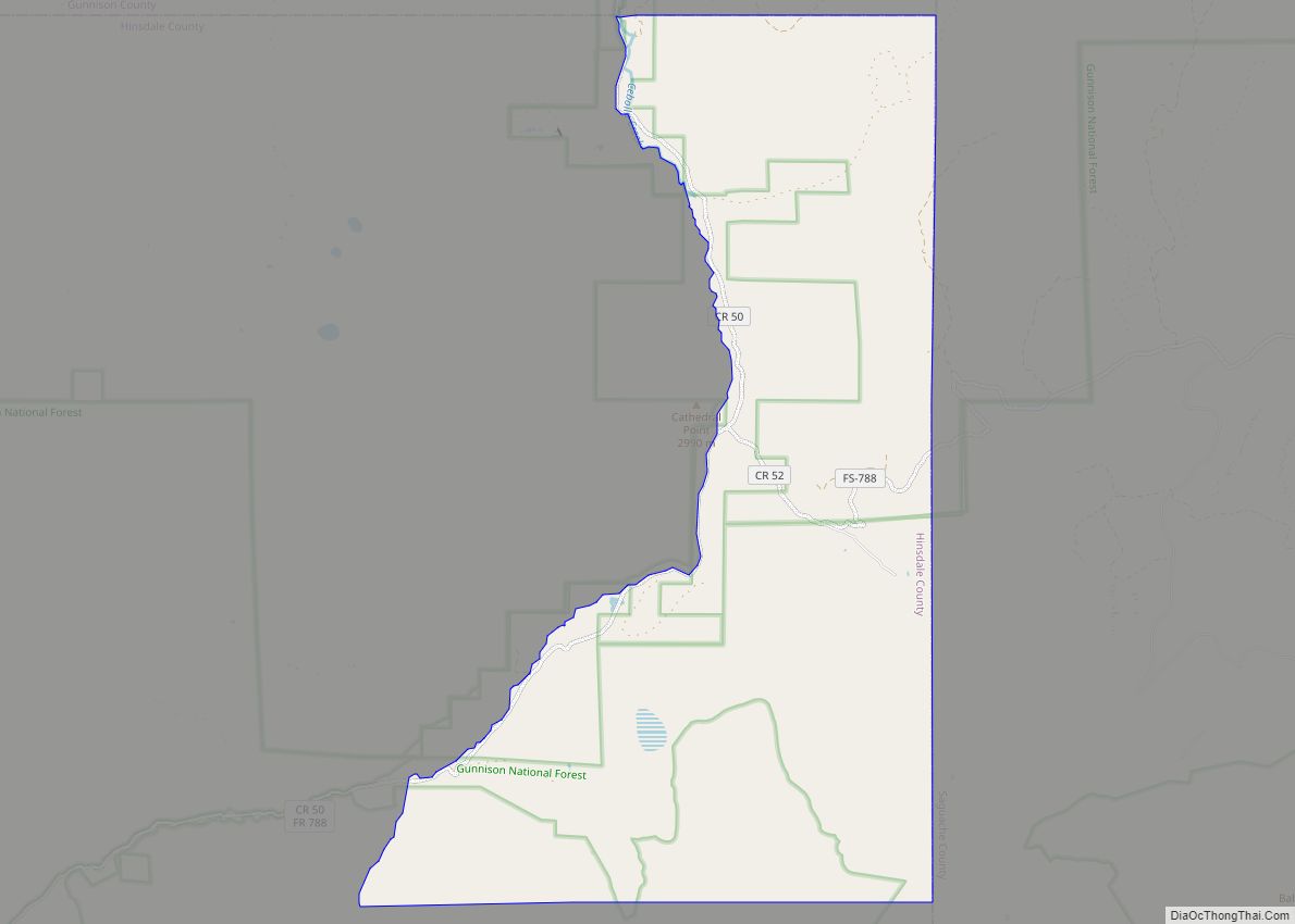
Cathedral is a census-designated place (CDP) located in and governed by Hinsdale County, Colorado, United States. The population of the Cathedral CDP was 15 at the United States Census 2020. The Powderhorn post office (Zip Code 81243) serves the area. Cathedral CDP overview: Name: Cathedral CDP LSAD Code: 57 LSAD Description: CDP (suffix) State: Colorado … Read more

Map of Castle Rock town

Map of Castle Rock town, Colorado

Castle Rock is a home rule town that is the county seat and the most populous municipality of Douglas County, Colorado, United States. The town population was 73,158 at the 2020 United States Census, a 51.68% increase since the 2010 United States Census. Castle Rock is the most populous Colorado town (rather than city) and … Read more

Map of Cedaredge town

Map of Cedaredge town

The Town of Cedaredge is a home rule municipality located in Delta County, Colorado, United States. The town population was 2,279 at the 2020 United States Census. Cedaredge sits in the Surface Creek Valley beneath the southern slopes of the Grand Mesa, the largest mesa in the world. Its elevated vantage point affords southern views … Read more

Map of Cañon City city

Map of Cañon City

Cañon City /ˈkænjən/ is a home rule municipality that is the county seat and the most populous municipality of Fremont County, Colorado, United States. The city population was 17,141 at the 2020 United States Census. Cañon City is the principal city of the Cañon City, CO Micropolitan Statistical Area and is a part of the … Read more

Map of Cattle Creek CDP

Map of Cattle Creek CDP

Cattle Creek is a census-designated place (CDP) in and governed by Garfield County, Colorado, United States. The CDP is a part of the Glenwood Springs, CO Micropolitan Statistical Area. The population of the Cattle Creek CDP was 662 at the United States Census 2020. The Glenwood Springs post office (Zip Code 81601) serves the area. … Read more

Map of Central City, Colorado

Map of Central City, Colorado

The historic City of Central, commonly known as Central City, is a home rule municipality located in Gilpin and Clear Creek counties, Colorado, United States. Central City is the county seat and the most populous municipality of Gilpin County. The city population was 779, all in Gilpin County, at the 2020 United States census. The … Read more

Map of Center town

Map of Center town, Colorado

The Town of Center is a Statutory Town located in Saguache and Rio Grande counties in Colorado, United States. The town’s population was 1,929 at the 2020 United States Census with 1,885 residing in Saguache County and 44 residing in Rio Grande County. Center town overview: Name: Center town LSAD Code: 43 LSAD Description: town … Read more

Map of Chacra CDP

Map of Chacra CDP

Chacra is a census-designated place (CDP) in and governed by Garfield County, Colorado, United States. The CDP is a part of the Glenwood Springs, CO Micropolitan Statistical Area. The population of the Chacra CDP was 331 at the United States Census 2020. The Glenwood Springs post office (Zip Code 81601) serves the area. Chacra CDP … Read more

Map of Cherry Hills Village city

Map of Cherry Hills Village city

The City of Cherry Hills Village is a home rule municipality located in Arapahoe County, Colorado, United States. The city population was 6,442 at the 2020 United States Census. Cherry Hills Village is a part of the Denver–Aurora–Lakewood, CO Metropolitan Statistical Area and the Front Range Urban Corridor. The city hosted two PGA Championships (1941 … Read more

Map of Cherry Creek CDP

Map of Cherry Creek CDP, Colorado

Cherry Creek is an unincorporated community and a census-designated place (CDP) located in and governed by Arapahoe County, Colorado, United States. The CDP is a part of the Denver–Aurora–Lakewood, CO Metropolitan Statistical Area. The population of the Cherry Creek CDP was 11,488 at the United States Census 2020. The ZIP code 80111 serves the area. … Read more

Map of Cheraw town

Map of Cheraw town, Colorado

The Town of Cheraw is a Statutory Town located in Otero County, Colorado, United States. The town population was 237 at the 2020 United States Census. Cheraw town overview: Name: Cheraw town LSAD Code: 43 LSAD Description: town (suffix) State: Colorado County: Otero County Incorporated: April 17, 1917 Elevation: 4,131 ft (1,259 m) Total Area: 0.183 sq mi (0.474 km²) … Read more

Map of City of Creede town

Map of City of Creede town

City of Creede town overview: Name: City of Creede town LSAD Code: 43 LSAD Description: town (suffix) State: Colorado County: Mineral County FIPS code: 0814765 Online Interactive Map City of Creede online map. Source: Basemap layers from Google Map, Open Street Map (OSM), Arcgisonline, Wmflabs. Boundary Data from Database of Global Administrative Areas. City of … Read more