Map of Goulds CDP

Map of Goulds CDP

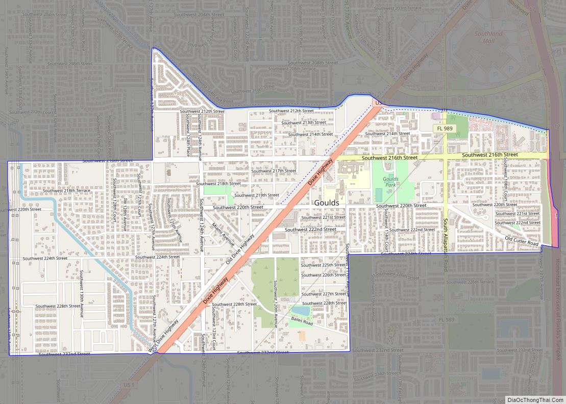
Goulds is an unincorporated community and census-designated place (CDP) in Miami-Dade County, Florida, United States. The area was originally populated as the result of a stop on the Florida East Coast Railroad. The railroad depot was located near the current Southwest 224th Street. The community was named after its operator, Lyman Gould, who cut trees … Read more

Map of Goulding CDP

Map of Goulding CDP

Goulding is a census-designated place (CDP) in Escambia County, Florida. It is considered to be a community within Pensacola. The population was 4,102 at the 2010 census. It is part of the Pensacola–Ferry Pass–Brent Metropolitan Statistical Area. Goulding CDP overview: Name: Goulding CDP LSAD Code: 57 LSAD Description: CDP (suffix) State: Florida County: Escambia County … Read more

Map of Gotha CDP

Map of Gotha CDP

Gotha is a census-designated place (CDP) in Orange County, Florida, United States. Gotha is located between Ocoee and Windermere and had a population of 1,915 at the 2010 census, up from 731 as recorded by the 2000 census. It is part of the Orlando–Kissimmee Metropolitan Statistical Area. It is the resting place of the famous … Read more

Map of Grant-Valkaria town

Map of Grant-Valkaria town

Grant-Valkaria is a town in Brevard County, Florida. The town’s population was 4,449 at 2022. Grant-Valkaria is located south of Melbourne, between Palm Bay and Sebastian. It is part of the Palm Bay–Melbourne–Titusville Metropolitan Statistical Area. Grant-Valkaria was incorporated as a town on July 25, 2006, by joining the two previously unincorporated communities of Grant … Read more

Map of Grand Ridge town

Map of Grand Ridge town, Florida

Grand Ridge is a town in Jackson County, Florida, United States. The population was 892 at the 2010 census, up from 792 at the 2000 census. Grand Ridge town overview: Name: Grand Ridge town LSAD Code: 43 LSAD Description: town (suffix) State: Florida County: Jackson County Elevation: 128 ft (39 m) Total Area: 4.52 sq mi (11.71 km²) Land Area: … Read more

Map of Graceville city

Map of Graceville city, Florida

Graceville is a city in Jackson County, Florida, United States. It is near the Alabama state line. The population was 2,278 at the 2010 census. A large portion of Graceville’s rural acreage is located in Holmes County, Florida, United States. Graceville city overview: Name: Graceville city LSAD Code: 25 LSAD Description: city (suffix) State: Florida … Read more

Map of Greenbriar CDP

Map of Greenbriar CDP, Florida

Greenbriar is an unincorporated community and census-designated place (CDP) in Pinellas County, Florida, United States. The population was 2,502 at the 2010 census. Greenbriar CDP overview: Name: Greenbriar CDP LSAD Code: 57 LSAD Description: CDP (suffix) State: Florida County: Pinellas County Elevation: 55 ft (17 m) Total Area: 0.64 sq mi (1.65 km²) Land Area: 0.60 sq mi (1.55 km²) Water Area: 0.04 sq mi … Read more

Map of Greenacres city, Florida

Map of Greenacres city, Florida

Greenacres is a city in Palm Beach County, Florida, United States. Situated in the east-central portion of the county, Greenacres is located northwest of Atlantis, east of Wellington, and borders Palm Springs to its east. As of the 2010 United States census, the city had a population of 37,573 people, up from 27,569 at the 2000 … Read more

Map of Green Cove Springs city

Map of Green Cove Springs city

Green Cove Springs is a city in and the county seat of Clay County, Florida, United States. The population was 9,555 at the 2020 census. In 2021, the population increased to 9,784. Green Cove Springs is a part of the Jacksonville Metropolitan Area, home to 1,637,666 residents. The city is named after the portion of … Read more

Map of Greenwood town, Florida

Map of Greenwood town, Florida

Greenwood is a town in Jackson County, Florida, United States. The population was 686 at the 2010 census. Greenwood town overview: Name: Greenwood town LSAD Code: 43 LSAD Description: town (suffix) State: Florida County: Jackson County Elevation: 115 ft (35 m) Total Area: 4.56 sq mi (11.82 km²) Land Area: 4.56 sq mi (11.82 km²) Water Area: 0.00 sq mi (0.00 km²) Total Population: 539 Population … Read more

Map of Greenville town, Florida

Map of Greenville town, Florida

Greenville is a town in Madison County, Florida, United States. The population was 746 at the 2020 census, down from 843 at the 2010 census. Greenville town overview: Name: Greenville town LSAD Code: 43 LSAD Description: town (suffix) State: Florida County: Madison County Elevation: 98 ft (30 m) Total Area: 1.32 sq mi (3.41 km²) Land Area: 1.32 sq mi (3.41 km²) Water … Read more

Map of Greensboro town, Florida

Map of Greensboro town, Florida

Greensboro is a town in Gadsden County, Florida, United States. The population was 602 at the 2010 census. Greensboro is part of the Tallahassee, Florida Metropolitan Statistical Area. Greensboro town overview: Name: Greensboro town LSAD Code: 43 LSAD Description: town (suffix) State: Florida County: Gadsden County Elevation: 269 ft (82 m) Total Area: 2.30 sq mi (5.97 km²) Land Area: … Read more