Map of Layton city

Map of Layton city, Florida

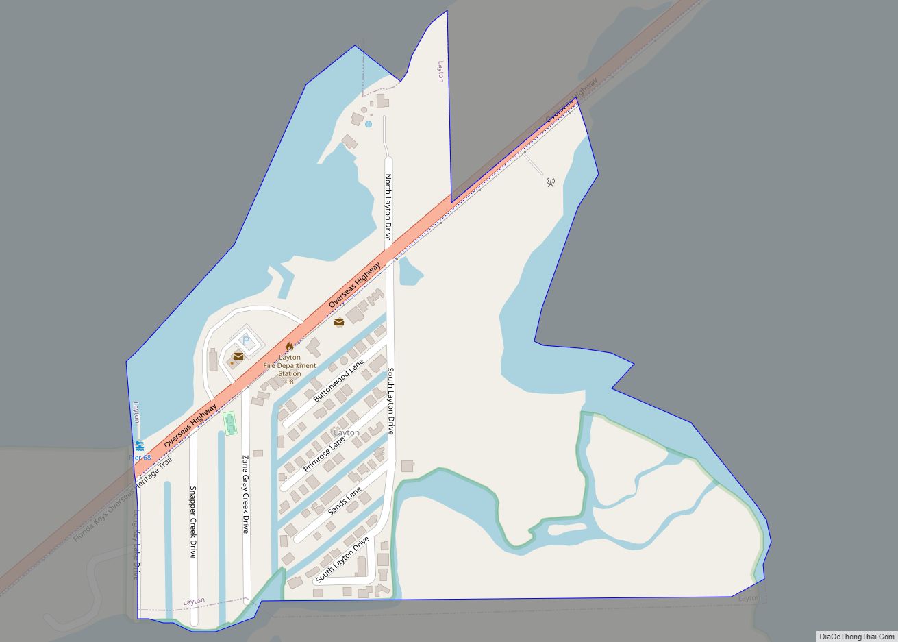
Layton is a city on the island of Long Key in Monroe County, Florida, United States. The population was 210 at the 2020 census. Layton city overview: Name: Layton city LSAD Code: 25 LSAD Description: city (suffix) State: Florida County: Monroe County Elevation: 3 ft (0.9 m) Total Area: 0.22 sq mi (0.58 km²) Land Area: 0.16 sq mi (0.42 km²) Water Area: … Read more

Map of Lawtey city

Map of Lawtey city

Lawtey is a city in Bradford County, Florida, United States. The population was 730 at the 2010 census, up from 656 in 2000. The city has received national attention and earned the dubious distinction of being one of only two official speed traps designated by the American Automobile Association (the other being Waldo a few … Read more

Map of Laurel CDP, Florida

Map of Laurel CDP, Florida

Laurel is a census-designated place (CDP) in Sarasota County, Florida, United States. The population was 12,186 as of 2020 census. Laurel is part of the North Port–Sarasota–Bradenton Metropolitan Statistical Area. Laurel CDP overview: Name: Laurel CDP LSAD Code: 57 LSAD Description: CDP (suffix) State: Florida County: Sarasota County Elevation: 10 ft (3 m) Total Area: 10.18 sq mi (26.38 km²) Land … Read more

Map of Lecanto CDP

Map of Lecanto CDP

Lecanto is an unincorporated community and census-designated place (CDP) in Citrus County, Florida, United States. As of the 2010 census it had a population of 5,882, up from 5,161 in 2000. It is home to several county government facilities such as the Citrus County Sheriff’s Office and the Citrus Campus of the College of Central … Read more

Map of Lealman CDP

Map of Lealman CDP

Lealman, known as East Lealman until 2010, is a census-designated place (CDP) in Pinellas County, Florida, United States. The population was 19,879 at the 2010 census. Prior to 2010, Lealman was part of a larger CDP named West and East Lealman. Community Redevelopment Area In 2015, the Pinellas County Board of County Commissioners created the … Read more

Map of Lazy Lake village

Map of Lazy Lake village

Lazy Lake is a village in Broward County, Florida, United States. The population was 33 at the 2020 census. Lazy Lake has no police department or fire department. Lazy Lake village overview: Name: Lazy Lake village LSAD Code: 47 LSAD Description: village (suffix) State: Florida County: Broward County Incorporated: June 3, 1953 Elevation: 3 ft (1 m) … Read more

Map of Lehigh Acres CDP

Map of Lehigh Acres CDP

Lehigh Acres is an unincorporated area and Municipal District in Lee County, Florida, United States. As of the 2020 Census the population was 135,272. Lehigh Acres is part of the Cape Coral-Fort Myers, Florida Metropolitan Statistical Area. Lehigh Acres is also one of the fastest growing communities in the State of Florida as well as … Read more

Map of Leesburg city, Florida

Map of Leesburg city, Florida

Leesburg is a city in Lake County, Florida, United States. The population was 20,117 at the 2010 census. As of 2019, the population recorded by the U.S. Census Bureau was 23,671. Leesburg is in central Florida, between Lake Harris and Lake Griffin, at the head of the Ocklawaha River. It is part of the Orlando–Kissimmee–Sanford … Read more

Map of Lee town

Map of Lee town, Florida

Lee is a town in Madison County, Florida, United States. The population was 375 at the 2020 census. Lee town overview: Name: Lee town LSAD Code: 43 LSAD Description: town (suffix) State: Florida County: Madison County Elevation: 92 ft (28 m) Total Area: 2.44 sq mi (6.31 km²) Land Area: 2.44 sq mi (6.31 km²) Water Area: 0.00 sq mi (0.00 km²) Total Population: 375 Population … Read more

Map of Leisure City CDP

Map of Leisure City CDP

Leisure City is an unincorporated community and census-designated place (CDP) in Miami-Dade County, Florida, United States, that includes the smaller, older community of Modello in its northwestern section. The population was 26,324 at the 2020 census, up from 22,655 in 2010. It is most notable for the Coral Castle Museum, located in the Modello area. … Read more

Map of Lely CDP

Map of Lely CDP

Lely is a census-designated place (CDP) in Collier County, Florida, United States. The population was 3,451 at the 2010 census. It is part of the Naples–Marco Island Metropolitan Statistical Area. Lely CDP overview: Name: Lely CDP LSAD Code: 57 LSAD Description: CDP (suffix) State: Florida County: Collier County Elevation: 7 ft (2 m) Total Area: 1.48 sq mi (3.82 km²) … Read more

Map of Lely Resort CDP

Map of Lely Resort CDP

Lely Resort is a census-designated place (CDP) in Collier County, Florida, United States. The population was 4,646 at the 2010 census, up from 1,426 in 2000. It is part of the Naples–Marco Island Metropolitan Statistical Area. In 2017, the population was 4,646. Lely Resort CDP overview: Name: Lely Resort CDP LSAD Code: 57 LSAD Description: … Read more