Map of Point Baker CDP, Florida

Map of Point Baker CDP, Florida

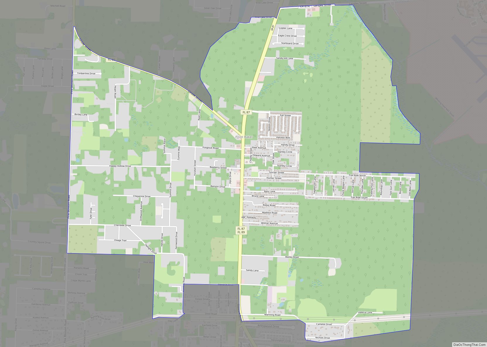
Point Baker is an unincorporated community and census-designated place in Santa Rosa County, Florida, United States. Its population was 2,991 as of the 2010 census. Florida State Road 87 and Florida State Road 89 intersect in Point Baker. Point Baker CDP overview: Name: Point Baker CDP LSAD Code: 57 LSAD Description: CDP (suffix) State: Florida … Read more

Map of Poinciana CDP

Map of Poinciana CDP

Poinciana (English: /pɔɪnsiˈænə/) is a settlement and census-designated place (CDP) in Osceola and Polk counties in the U.S. state of Florida. It lies southwest of Kissimmee and approximately 14 miles (23 km) east of Haines City. As of the 2010 United States Census, the CDP had a population of 53,193. As of April 2012 the population … Read more

Map of Plantation CDP

Map of Plantation CDP, Florida

Plantation is a census-designated place (CDP) in Sarasota County, Florida, United States. The population was 4,919 at the 2010 census. It is part of the Bradenton–Sarasota–Venice Metropolitan Statistical Area. Plantation CDP overview: Name: Plantation CDP LSAD Code: 57 LSAD Description: CDP (suffix) State: Florida County: Sarasota County Total Area: 2.5 sq mi (6.5 km²) Land Area: 2.2 sq mi (5.7 km²) … Read more

Map of Pomona Park town

Map of Pomona Park town

Pomona Park is a town in Putnam County, Florida, United States. The population was 912 at the 2010 census and has gone up to 916 in the 2018 estimates. The town is part of the Palatka Micropolitan Statistical Area. Pomona Park town overview: Name: Pomona Park town LSAD Code: 43 LSAD Description: town (suffix) State: … Read more

Map of Polk City town

Map of Polk City town, Florida

Polk City is a city in Polk County, Florida, United States. The population was 1,562 at the 2010 census. As of 2018, the population recorded by the U.S. Census Bureau is 2,422. It is part of the Lakeland–Winter Haven Metropolitan Statistical Area. Polk City town overview: Name: Polk City town LSAD Code: 43 LSAD Description: … Read more

Map of Ponce de Leon town

Map of Ponce de Leon town

Ponce de Leon (/ˌpɒns də ˈliːən/ PONSS də LEE-ən) is a town in Holmes County, Florida, United States. The population was 598 at the 2010 census, up from 457 at the 2000 census. From 2000 to 2010, the Ponce de Leon town population growth percentage was 30.9%. Ponce de Leon town overview: Name: Ponce de … Read more

Map of Port LaBelle CDP

Map of Port LaBelle CDP

Port LaBelle is a census-designated place (CDP) in Hendry and Glades counties, Florida, United States. The population was 3,530 at the 2010 census, up from 3,050 at the 2000 census. Port LaBelle CDP overview: Name: Port LaBelle CDP LSAD Code: 57 LSAD Description: CDP (suffix) State: Florida County: Hendry County Elevation: 10 ft (3 m) Total Area: … Read more

Map of Port Charlotte CDP

Map of Port Charlotte CDP

Port Charlotte is an unincorporated community and census-designated place (CDP) in Charlotte County, Florida, United States. The population was 60,625 at the 2020 census. It is part of the Sarasota-Bradenton-Punta Gorda Combined Statistical Area. Port Charlotte was named to the “10 Best Places to Retire”, in the United States for the year 2012 by U.S. … Read more

Map of Ponce Inlet town

Map of Ponce Inlet town

Ponce Inlet is a town in Volusia County, Florida, United States. The population was 3,032 at the 2010 census. The town of Ponce Inlet is located on the southern tip of a barrier island, south of Daytona Beach and Daytona Beach Shores. Several marinas are located in Ponce Inlet. The community is known for its … Read more

Map of Port Salerno CDP

Map of Port Salerno CDP

Port Salerno is an unincorporated community and census-designated place (CDP) in Martin County, Florida, United States. The population was 10,401 at the 2020 census. It is part of the Port St. Lucie Metropolitan Statistical Area. Port Salerno CDP overview: Name: Port Salerno CDP LSAD Code: 57 LSAD Description: CDP (suffix) State: Florida County: Martin County … Read more

Map of Port Richey city

Map of Port Richey city

Port Richey is a city in Pasco County, Florida, United States. It is a suburban city included in the Tampa-St. Petersburg-Clearwater, Florida Metropolitan Statistical Area. Port Richey city overview: Name: Port Richey city LSAD Code: 25 LSAD Description: city (suffix) State: Florida County: Pasco County Elevation: 10 ft (3 m) Total Area: 2.28 sq mi (5.90 km²) Land Area: 2.22 sq mi … Read more

Map of Port Orange city

Map of Port Orange city

Port Orange is a city in Volusia County, Florida. The city’s population was estimated at 64,842 in 2019 by the U.S. Census Bureau. The city is part of the Deltona–Daytona Beach–Ormond Beach metropolitan area; the metropolitan area’s population in 2010 was 590,289. Port Orange is a principal city in the Fun Coast region of the … Read more